
Bureau of Meteorology: Midweek heatwave to buck La Nina trend, thunderstorms expected in southwest Queensland weather
With a heatwave radiating across the Sunshine State, wild weather is expected to hit southwest Queensland this week, completely bucking the prediction of a ‘cool and wet’ summer the La Nina system was expected to bring. See the forecast.
Warwick
Don't miss out on the headlines from Warwick. Followed categories will be added to My News.
Wild weather is expected to cause chaos across southwest Queensland, with temperatures to soar across the region and thunderstorms forecast to follow.
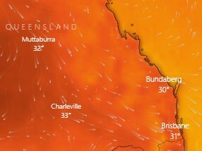
Queensland was expected to be slammed by a summer heatwave with temperatures in some places to reach the 40s.
It’s believed temperatures could climb to 10-15c higher than last week’s daytime maximums, with parts of outback Queensland expected to get to 46C.
Birdsville in the state’s Channel Country was Queensland’s hottest place on Tuesday, hitting 40.2C at 10.27am, while Winton and Longreach were both above 37C.
Wednesday is expected to bring scorching temperatures to several southwest communities such as St George and Goondiwindi, where top temperatures of are likely 40C, while Warwick and Toowoomba are expected to reach 35C.
As humidity builds through the week, showers and storms will become more likely through to the weekend.
The Bureau of Meteorology’s senior meteorologist Pieter Claassen said while a heatwave was less likely during a La Nina system, it was not unheard of.
“The temperatures we are forecasting are very warm but not unprecedented – some places could see their warmest December day in about three years,” Mr Claassen said.
“In the southeast, a series of troughs are bringing largely northerly winds to the region, which is dragging the very hot temperatures to the north southwards over the area.”
Queensland’s heatwave conditions are being triggered by the departure of a low, which will allow hot air that has been building in the north to sweep south into the state from Tuesday.
“Normally it’s the other way around, you’d get a slow build-up of heat, and then you get a sudden, cool change,” meteorologist Livio Regano said.
“What’s happening here is that for the last several days, our whether has been dominated by this low off the coast. But today is its last day, it’ll push away very, very quickly.
“This blob of cool air that’s been sitting over southeast Queensland all this time moves off and gets instantly displaced by a new blob of air coming from the north and it’s a much warmer one.”
See the weeks forecast for your area:
Warwick
In the Southern Downs, Warwick is expected to heat up to the mid 30s on Wednesday and Thursday, with temperatures dropping off by Friday.
Storms possible on both days, with Friday expected to be mostly sunny.
Dalby
Dalby and the Surat Basin is expected to hit a blistering 37c on Wednesday, with a 20 per cent chance of late storms in the afternoon.
Temperatures could possibly reach 40C on Wednesday and UV index is expected to reach extreme levels, but is expected to cool slightly by the weekend.
Roma
Further west in Roma, 40C is expected on Wednesday, with a chance of a thunderstorm in the late afternoon.
The warmer temperatures are likely to stick around into the next week, with an average through the weekend to be in the low 30s.
Toowoomba
Thunderstorms possible in Toowoomba from the mid week, which will cool the city down compared to other cities mentioned.
Low 30s temperatures throughout the week, with light winds and a 20-30 per cent chance of rain.
Temperatures are expected to fall to mid 20s by the weekend.


Fireys battle large grass fire near Warwick
Fireys are working to contain a fast-moving grass fire near Warwick. Here’s the latest.

SNOW good: Thousands set to attend popular winter festival
Beanies, gloves and jackets will be easier to spot than Wally at southeast Queensland’s popular winter festival this weekend, with ticket sales through the roof.