
Sunshine Coast weather: Storm cell bears down on region
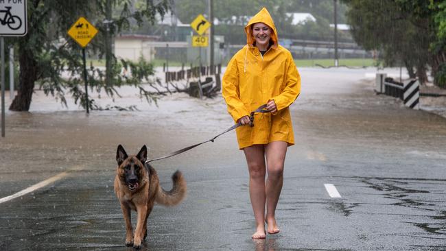
Sunshine Coast residents are being warned they face an ‘extreme’ flood emergency with one major river threatening to impact homes. An alert was issued for Kawana residents while the Noosa hinterland has been hammered.
Sunshine Coast
Don't miss out on the headlines from Sunshine Coast. Followed categories will be added to My News.
Sunshine Coast residents are being warned they face an ‘extreme’ flood emergency with one major river threatening to impact homes.
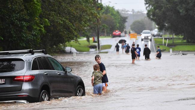
Already there have been motorists rescued and people stuck on a roof at Yandina.
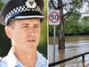
An emergency alert was issued on Friday night as the Mooloolah River recorded a major flood level.
Sunshine Coast Council said the Creekside and Kawana Forest area could be impacted with flood levels expected to be elevated for some time.
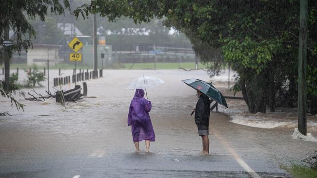
In its latest advice, the weather bureau said up to 370mm of rain had been recorded on the Sunshine Coast to 2am on Saturday.
Torrential rain has continued throughout Friday night and into Saturday.
There were totals of 50mm to 230mm on the Coast on Friday.
An emergency alert has been issued to residents in Gympie withweather bureau saying the Mary River at Gympie could top 22m – above the 1999 flood levels.
A staggering 415mm had been recorded at Pomona, with the heaviest falls in the upper reaches of the Mary River above Gympie and in the headwaters of Tinana Creek.
The Bureau of Meteorology‘s automatic station recorded more than 920mm at Pomona between Tuesday morning and Friday.
About 880mm fell during the same period at Cooran, 620mm at Moy Pocket, and 720mm at Kin Kin.
Rescue authorities have pleaded with others to stay off the roads to avoid ‘life and death’ rescue situations in their cars.
Further heavy to intense rainfall is forecast to continue during Saturday.
Minor to major flooding is occurring across areas of the catchments early Saturday morning.
A severe weather warning for heavy rainfall is current for the Southeast Coast and parts of Wide Bay and Burnett and Darling Downs and Granite Belt Forecast Districts.
Maroochy River:
Minor flooding may occur along the Maroochy River.
The Maroochy River at Dunethin Rock was at 2.01 metres (below minor) and rising. The Maroochy River at Dunethin Rock is likely to remain below the minor flood level (2.90m) Saturday morning. However, renewed river level rises are possible during Saturday with further heavy rainfall.
The Maroochy River at Picnic Point was at 1.11 metres (below minor) and rising. The Maroochy River at Picnic Point may exceed the minor flood level (1.30m) on the high tide Saturday morning.
Noosa River:
Moderate flooding may occur along the Noosa River.
The Noosa River at Tewantin was at 1.12 metres (above minor) and rising. The Noosa River at Tewantin may reach the moderate flood level (1.30m) on the high tide Saturday morning. Higher levels are possible over the weekend with further heavy rainfall.
Mooloolah River:
Major flooding may occur along the Mooloolah River.
The Mooloolah River at Palmview peaked at 4.89 metres mid-evening Friday and was at 4.69 metres (moderate flooding) and steady. The Mooloolah River at Palmview is likely to fall below the moderate flood level (4.60m) Saturday morning. However renewed rises and major flooding are possible again over the weekend with further heavy rainfall forecast.
Coochin Creek:
Minor to moderate flood levels are slowly easing along the Coochin Creek early Saturday morning. With further heavy rainfall forecast, renewed rises and significant creek levels are possible over the weekend.
WILD WEATHER SET TO EXTEND INTO SUNDAY
The Bureau of Meteorology has warned the barrage is far from over with the chance the system could intensify again overnight Friday and deliver another deluge Saturday morning.
Forecasters expect rain to continue into Sunday and up to 200mm could fall across the Sunshine Coast and Noosa over the next 24 hours into Saturday as Gympie and the Lockyer Valley are also inundated.
Meteorologist Felim Hanniffy said the Sunshine Coast and Noosa was in the firing line from yet another slow moving system bringing torrential rain for the next 24-36 hours.
Mr Hanniffy said while he believed the weather event peaked on Friday, more of the same was due on Saturday and potentially overnight on Sunday.
“The overnight risk is the trough intensifying and pushes back with these heavy falls, it’s likely to be pretty prolonged,” Mr Hanniffy said of Friday night’s forecast.
âš ï¸Severe weather warning continues for #SEQ. Heavy rain with locally intense falls leading to dangerous and life threatening flash flooding expected to continue overnight. https://t.co/FBmpsInT9opic.twitter.com/Ct605Ns46k
— Bureau of Meteorology, Queensland (@BOM_Qld) February 25, 2022
“200mm falls again over the next 24 hours, a really high impact weather event that’s slow moving.
“The southeast will be impacted with the Sunshine Coast and northern parts right in the firing line.”
Mr Hanniffy said the threat contained intense rainfall and severe thunderstorms with the potential for 160mm falls in an hour.
“The thunderstorms are when it really ramps up, high calibre falls,” he said.
“And this is happening on a serious saturated catchment area.
“Friday was probably the peak of it but it may not ease until Sunday.”
Initial forecasts had tipped the system to ease Saturday, with 30-60mm forecast to fall but those predictions have been scaled up as the system continued to drench large parts of the southeast on Friday.
SCHOOLS OUT EARLY
Several schools across the Sunshine Coast closed early on Friday and advised parents to do the school collection early.
“We have made the decision to close the school today, if it is safe and you are able to do so could you please collect your children from school,” Sunshine Coast Grammar School posted to its social media about midday on Friday read.
“The school is closed due to flooding.”
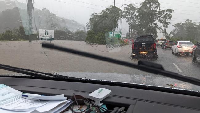
BRUCE HIGHWAY CUT OFF
The Department of Transport and Main Roads has closed a 4.5km stretch of the Bruce Highway at Caboolture due to flooding.
Minister Mark Bailey said traffic will be reduced to one lane each way for people travelling between Brisbane and the Sunshine Coast.
He said the section was expected to be closed for 24 hours.
“This means traffic will be reduced to one lane each way for people travelling between Brisbane and the Sunshine Coast,” he said.
“This is expected to create significant delays, so we are asking people to avoid the area.
“Further north, the Bruce Highway is cut off just south of Gympie, and the Lamington Bridge in Maryborough is also flooded.”
Southbound traffic will be diverted at the Steve Irwin Way exit and returned to the Bruce Highway before the Bribie Island exit.
🛑 The Bruce Highway near King Johns Creek is closed from this afternoon due to this week's record rains 🛑
— Transport and Main Roads Queensland (@TMRQld) February 25, 2022
We've closed the southbound carriageway and we are implementing contra flow traffic on the northbound lanes of the highway for the next 24 hours. pic.twitter.com/LP2KIY5EGz
SUNSHINE COAST FLIGHTS DIVERTED
Sunshine Coast Airport has become the latest victim of severe weather across the region with several flights diverted to Brisbane.
A statement from the airport said “extreme rain” made for low visibility on the runway.
“Some flights have been diverted to Brisbane Airport and we advise all travellers to keep updated on the status of flights in and out of Sunshine Coast Airport via our website here,” the statement read.
Three arriving flights from Sydney and Melbourne were due to touch down at Marcoola later today.
New figures released by the bureau on Friday afternoon show the staggering amount of rain. Since 12am Pomona recorded 445mm in just 10 hours, Cooran had 410mm, Hills Road 329mm, Moy Pocket recorded 315mm while Mt Glorious recorded 280mm.
Meanwhile, the 2022 Youth State Championships event at Alexandra Headland and Mooloolaba has been fully suspended.
All competition, including beach and water events have been cancelled and the Festival Zone is closed.
LANDSLIDE, SWIFTWATER RESCUES UNDERWAY
Firefighters and swiftwater rescue crews are responding to reports of several major incidents across the Sunshine Coast this afternoon.
A Queensland Fire and Emergency spokeswoman said they have received reports a person has been stranded in their vehicle in flood waters along Dath Henderson Rd in Lake McDonald.
The spokeswoman said several crews were headed to assist about 4.30pm, while others were attending to another car stuck in floodwaters along Margaret St in Palmwoods.
Multiple crews have also reached Bahrs Rd in the Glasshouse Mountains to assist a person in need of assistance while in the water.
SES units have been deployed across areas such as Woombye, Coolum and Beerwah to help with sandbagging flood-ravaged areas.
Earlier a Queensland Fire and Emergency Services spokesman said four crews are on-scene at North Arm-Yandina Creek Rd after reports of a white hatchback stuck in floodwater.
The spokesman said the call for help was made about midday and four crews rushed to the scene.
The vehicle was reportedly stuck in floodwaters about 1.3m deep and rising and it was unknown whether anyone was inside the vehicle at this stage.
A spokeswoman later confirmed there were no occupants in the vehicle.
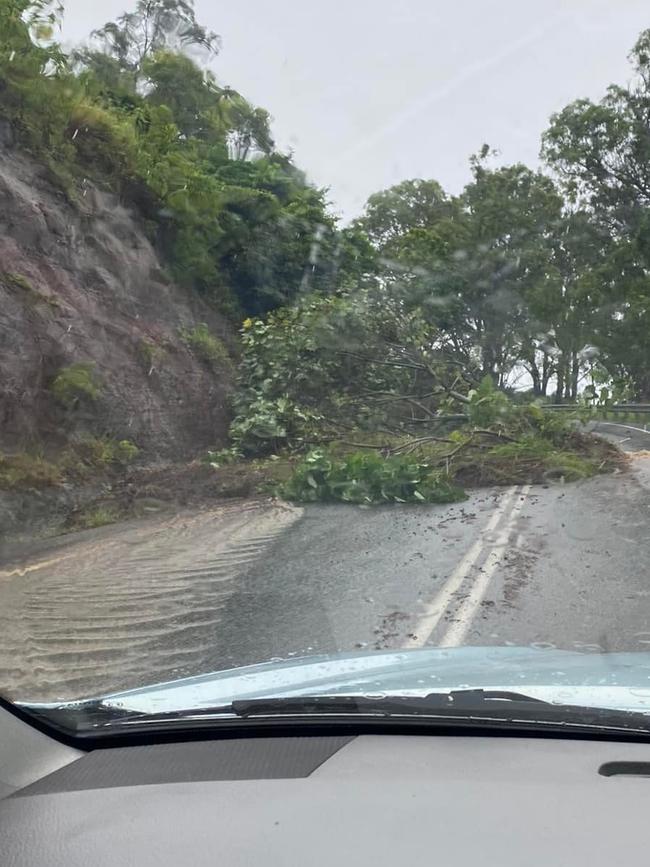
Meanwhile firefighters have rushed to Tanawha after reports of a landslide impacting a house at Sarah Ct, near Topview Dr.
It was later confirmed to be a false alarm, however, nearby roadways were cut off by flooding.
Another rescue was also underway at Tablelands Rd, Cooran, after reports about 12.20pm of a man in a wheelchair unable to evacuate a property.
Three firefighting rescue crews were also headed to Crohamhurst, near Peachester, to reports of a tree which has fallen onto a car on Bald Knob Rd and Candle Mountain Dr.
More to come on these incidents.
Meanwhile the weather bureau issued a warning on Friday morning that very dangerous thunderstorms were detected on the weather radar near the area southwest of Noosa Heads, the area west of Noosa Heads, Kenilworth, Eumundi, Cooroy and the area southwest of Eumundi.
The dangerous deluge has already cost two lives after police identified a Gympie dad and Belli Park woman as the victims of separate flash flooding tragedies.
It’s a second battering for the region after more than 400mm was recorded in some parts of the hinterland overnight Tuesday and into Wednesday.
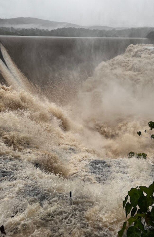
Emergency alert issues for Imbil as Borumba Dam overflows and threatens nearby homes.
An emergency alert has also been issued for the small town of Goomeri, west of Gympie, Woolooga and towns further west.
On the Sunshine Coast, flood warnings have been issued for the Noosa, Maroochy and Mooloolah Rivers.
CHECK BELOW FOR ALL THE LATEST ON MAJOR INCIDENTS, ROAD CLOSURES AND MORE.
TOWNS INUNDATED
One of the main entries to Pomona has been cut off by fast-moving, rising floodwaters.
Pomona childcare worker Rachael Cowie said the rain had been torrential since 4am Friday.
Ms Cowie said the Hill St childcare had closed for the day because the weather had cut families off.
She said it was unlike anything she had seen before.
“It’s absolutely unreal,” Ms Cowie said.
“There’s just so much water coming off the mountain.”
One gentleman who broke down on Hill St risked a walk through floodwaters to get a jerry can of fuel.
Ms Cowie said she wouldn’t dare cross the fast moving waterway.
“He ended up risking it and going across, but there’s no way I’d be attempting that,” she said.
“Most of the roads around here are cut off or closed. The creeks are rising too fast.”
Fellow Pomona resident Shayde Dwyer said the weather had been intense and constant.
She too said she hadn’t seen anything of this nature.
Meanwhile reports of flash flooding continue to pour in with traffic in Kunda Park being diverted back towards Maroochydore as floodwaters surge across Maroochydore Rd.
Camp Flat Rd in Bli Bli is also reportedly underwater while flash flooding has also been reported in Mooloolah Valley.
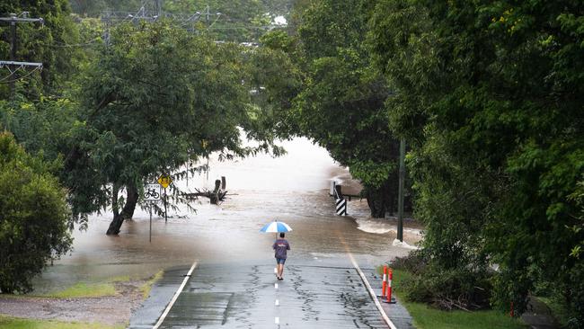
Buderim residents described Lindsay Rd, Buderim as being a “river for as far as the eye can see”.
WHAT’S TO COME
An entire month’s worth of rain could be dumped on an already saturated Sunshine Coast with the weather bureau on high alert for a “very dangerous” system approaching.
The weather bureau has warned that a slow moving coastal trough could bring torrential rain and damaging winds embedded in severe thunderstorms.
Forecaster Brooke Pagel said the system could easily bring downpours of between 100-200mm, with more intense patches closer to 300mm possible.
Ms Pagel said the trough was currently offshore north of Fraser Island but was poised to head towards the Sunshine Coast and Noosa today.
Swift water rescue underway near Nambour after the driver of a van became trapped by floodwater. pic.twitter.com/inRY9ZBlBw
— Josh Bavas (@JoshBavas) February 24, 2022
It comes after two days of intense rainfall soaked the region and tragically resulted in the death of a Belli Park woman and a Gympie man from flooding.
“It will be a dangerous day,” Ms Pagel said.
“Intense rainfall on saturated catchments could make for dangerous conditions and life threatening flash flooding.”
Ms Pagel said the February average rainfall was 205mm.
“So we could have a months’ worth of rain in 24 hours,” she said.
A State Emergency Services spokesman said things were ramping up this morning following about 60 calls for assistance overnight.
Latest flood advice stated Palmview, Tewantin and Picnic Point were likely to go experience flooding this evening.
SNOWSTORM ON BEACHES
The wild weather whipped up a foam ‘snow’ storm on Sunshine Coast beaches on Thursday afternoon.
Mooloolaba’s famous beach’s blue waters were turned to brown after hundreds of millimetres of rain while the beach and rocks were covered with a cappuccino-like froth.
Some children couldn’t resist the temptation, playing in the murky mix as parents snapped pictures for social fame.
One man even walked his sausage-like dachshund through the muck despite jibes from others that the dog may disappear.
Back in the January 2013 storms, beach foam from Alexandra Headland spilt onto the road.
Amazing video of two police officers nearly being run over by a motorist eager to get through thick foam went viral.
The video shows a bus heading through the foam when a “wave” suddenly picks up and heads towards the officers.
A set of headlights then emerges as a car ploughs through the other end.
Experts say sea foam forms when dissolved matter in the water is agitated by wind and waves on a grand scale.
Seawater contains dissolved salts, proteins, fats, dead algae, detergents and other pollutants, as well as organic and artificial matter.
While generally most sea foam is not harmful, when large algal blooms decay near shore, there is potential for impacts to human health and the environment.
People trapped by rising floodwaters at Amamoor
Swift water rescue crews are on their way to a home on Amamoor Creek Rd at Amamoor Creek, with reports of people stranded inside a home surrounded by rising waters.
A Queensland Fire and Emergency Service spokesman said two crews were on their way to the scene with support from other QFES personnel after they were called just after 9am on Friday.
âš ï¸Severe Thunderstorm Warning UPDATE: Very dangerous slow moving storms forecast to affect #Yandina by 7:35am #Conondale#Nambour, area W of #Conondale by 8:05am. Intense rainfall that may lead to dangerous life threatening flash flooding likely. Updates https://t.co/FXEp8bA49qpic.twitter.com/raDWh0qcRh
— Bureau of Meteorology, Queensland (@BOM_Qld) February 24, 2022
CARS TRAPPED, MAJOR EVENT POSTPONED:
Two people had to be freed from a car in Nambour this morning after water rose to the wheel level.
Swiftwater rescue firefighters were called to Nambour Connection Rd and National Park Rd about 6.45am Friday to reports of two people trapped in a car.
A Maryborough couple were walked out after waking to find their car surrounded by rising floodwaters.
Floodwaters had reportedly reached wheel level prompting the call for assistance.
A Queensland Fire and Emergency Services spokeswoman said swiftwater rescue technicians had taken two people safely from the car about 7.20am.
Meanwhile a major youth surf life saving event has been postponed as the region cops more of a drenching.
The 2022 Youth State Championships was suspended early Friday morning with further assessments to be made at 10am.
Competitors and spectators have been asked to stay away from Alexandra Headland and Mooloolaba, with updates on the event to come later in the day.
EARLIER:
Tragedy struck with 63-year-old Philippa Tayler of Belli Park found dead in her submerged car on Skyring Creek Rd, Belli Park on Wednesday morning.
The desperate search for Gympie father-of-three Phil Lambert was understood to have taken a tragic turn with a body found in Cedar Pocket after his motorcycle was found on Wednesday morning.
A massive band of rain is pommeling residents from Bundaberg to the Gold Coast and out west to Ipswich and Gatton.
A staggering 423mm of rain has fallen in the six hours to 4.30am in Biggenden, west of Maryborough.
Other major rainfall totals over the same period include 315mm at Fig Tree north of Biggenden, 289mm at Paradise Dam, 241mm at Fred Haigh Dam and 158mm at Kandanga.
The latest warning says the worst of the severe weather will affect the Wide Bay and Burnett, Southeast Coast and parts of Darling Downs and Granite Belt forecast districts, with six-hourly rainfall totals between 80 and 120mm.
Up to180mm over areas east of Gympie to Jimboomba could fall.
“Locally intense rainfall leading to dangerous and life-threatening flash flooding is possible with thunderstorms during this period, particularly over areas north of Brisbane,” the warning said.
“Six-hourly rainfall totals in excess of 300mm are possible.
“Damaging wind gusts with peak gusts in excess of 90 km/h are possible over areas east of about Seventeen Seventy to Brisbane, although most likely near the coast north of Maroochydore.
A flood watch, flood warnings and severe weather warning are current for parts of Southeast Queensland and northern New South Wales. Locations which may be affected include Toowoomba, Brisbane, Maroochydore, Gympie, Bundaberg, Kingaroy, Caboolture, Ipswich, Cherbourg, Oakey, Jimboomba and Mount Tamborine.”

Pauline Smith from Lake Cooroibah in the Noosa hinterland said she had been ‘absolutely’ hammered by thunder and lightning.
“All the roads around will be under,’’ she said.
Brookey McKinnon reported that there was a bridge flooded even at Mt Perry.
Karen Davis, who lives on a permanent campsite, said her tarps had collapsed under the weight of the rain. Many were feeling for the people of Gympie, Bundaberg, and Fraser Coast regions which went under only weeks ago.
Others were wondering how the homeless would cope under the deluge.
“This is insane, it has not stopped bucketing down here at Booyal. I think I will keep and eye out for an Ark,’’ Kris Svensson said.
Melissa Muldoon said Deepwater and Baffle Creek, south of 1770, was getting hit hard.
“The lightning & thunder is scary as @#$*” Jane Dobbie said it was also poured at Russell Island.
“If this keeps up the southern part of the island may get cut off by flooding in the swamps from the rest of the island!”
Isabella Parslow at Glenwood said the rain had been non stop since about midnight. “(It) woke me up around 2 bucketing down and hasn't stopped since … I'm expecting the dam to be overflowing.’’
Kaylea Maher said the rain at Imbil was ‘extreme’.
“Looks like the majority of Mary River catchment upstream from Gympie is copping it. Hope all were prepared downstream.”
Daniel Wayne said the lightning strikes at Biggenden were incredible but ‘scary as f***’
Sharon Kelland at Coolum Beach reported it ‘bucketing down with crazy wind’.
Tula Mae Bollendorff said she just got the cows out of flood waters ‘but silly things won’t go on top of dam wall’. “Hope if it rises more they will because I don’t think we can cross the “creek”, which is now a torrent river, again … there’s just no where left for water to go.”
Earlier, frontline disaster volunteers are bracing for another afternoon of carnage.
The deluge lurking off the coast was expected to hit Rainbow Beach first before making its way across the Sunshine Coast and further south this afternoon.
âš ï¸Severe Thunderstorm Warning: Severe storms developing over southern inland areas. These are likely to produce damaging winds, heavy rainfall and flash flooding over the next several hours. Locations include Roma, Goondiwindi, and Barcaldine.
— Bureau of Meteorology, Queensland (@BOM_Qld) February 24, 2022
Warnings: https://t.co/FBmpsInT9opic.twitter.com/2B51t4TJyr
Sunshine Coast SES local controller Brendan Casement said volunteers had worked until midnight Wednesday responding to 115 calls for assistance across the region.
He said the majority were for leaking roofs and houses inundated with floodwater.
Mr Casement said most of the calls had been from Caloundra, Nambour and Maroochydore with a handful from further afield in Maleny and Glasshouse.
A caravan was washed away in Kenilworth Showgrounds about 4.30am Wednesday and a family had to be relocated.
“At the moment it’s a bit of a calm before the storm,” Mr Casement said on Thursday morning.
He said members had been able to get a rest after midnight as they geared up for another long night ahead.
He said the forecast indicated the Sunshine Coast would be first in the firing line before the system moved south to Brisbane and beyond.
Mr Casement said there was a “high risk” of trees coming down with grounds sodden from the deluge and high winds forecast.
Rainfall was expected to roll through to Saturday with up to 300mm tipped to come down over the next 72 hours across the southeast.
Flood warning remained in place for Sunshine Coast rivers and catchments.


Neighbour shares worrying detail after 4yo’s devastating fall
A neighbour has revealed safety concerns in the weeks leading up to the serious fall of a four-year-old boy off a balcony on the Sunshine Coast.
Read more

Cosmic reserve potential star in future tourism plans
A Queensland council’s proposed protection of its hinterland’s stunning night sky could bolster astro-tourism in the area with the plan open for public feedback.
Read more