
Normanby, Pengelly’s bridge to be cut, family flown to safety
A family has been rescued after more than four hours surrounded by rising floods as an evacuation continues in Gympie which has now been isolated by its worst flood in decades. PHOTOS, VIDEO, LATEST UPDATES:
Gympie
Don't miss out on the headlines from Gympie. Followed categories will be added to My News.
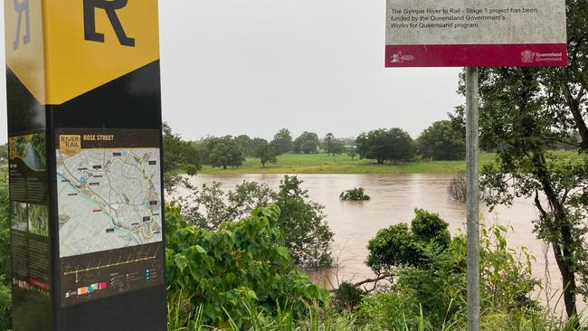
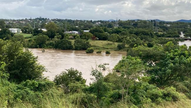
The Bruce Highway is cut at Gympie and to its north, and the city is isolated from the south and from its largest suburb, the Southside.
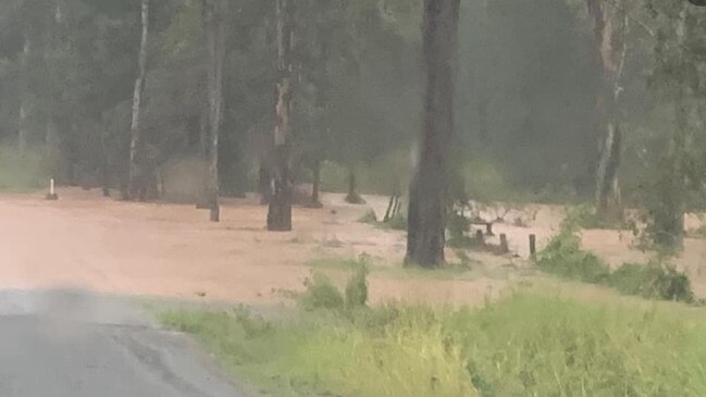
Normanby Bridge, the highest bridge in the city straddling the Mary River, closed about 2.30pm and Pengelly’s Bridge, which was offering a alternate route for stranded Bruce Highway traffic, is now also under water as Gympie prepares for possibly its worst flood since 1999.
The Bureau of Meteorology predicts that flooding in Gympie could reach the February 1999 height of almost 22m, the third worst flood in its history. The Bruce Highway at Deep Creek is now cut.
Bells Bridge, north of Gympie, was closed on Friday morning.
An emergency alert was issued for Cedar Pocket Dam at 1pm Friday, where residents downstream of the dam were told to stay alert and monitor changes in conditions.
As of 12.19pm, the dam had reached 165.7 per capacity and was spilling into nearby catchments.
Meanwhile, a family stranded in a house surrounded by rising floodwaters at Amamoor Creek as been airlifted to safety.
With further rainfall expected to continue over the next 24 hours and a severe weather warning current for the Wide Bay, the Gympie community is frantically evacuating multiple businesses and sporting clubs.
New figures released by the bureau on Friday afternoon show the staggering amount of rain. Since 12am Pomona recorded 445mm in just 10 hours, Cooran had 410mm, Hills Road 329mm, Moy Pocket recorded 315mm while Mt Glorious recorded 280mm.

The February 1999 flood of 21.95m was the third worst Gympie had experienced. The second worst flood in history was in 1898, when it peaked at 22m.
Lower Mary St has been closed to traffic as moving trucks and shipping containers line footpaths and are filled with important furniture.
Imbil is now flooding with an increasing outpour from nearby Borumba Dam, with a warning to residents below the dam to stay alert and monitor changes in conditions.
A home video posted by the Kandanga Country Club on Friday showed floodwaters raging through the heart of the small Mary Valley township.
The dam is at 111.4 per cent capacity as of Friday morning, according to SEQ water.
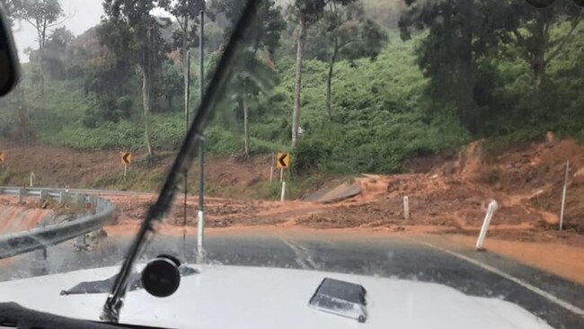
The Bruce Highway and the Southside of Gympie are expected to be cut in the early afternoon after the Mary River’s catchment area was inundated by another 200mm or rainfall over night.
An Amamoor Creek family were flown to safety in the Sunshine Coast after they spent hours stranded in their home surrounded by rising flood waters.
A LifeFlight spokesperson said five people were at the scene, but could not confirm if they were all aboard the helicopter.
As of 8.20am, Moy Pocket had been on the receiving end of another 266mm of rain, and Kenilworth had recorded 203mm.

That water is now making its way down the Mary River, and is expected to push it above the 15.8m height of Normanby Bridge, the main access point to the town shortly after midday.
The Inglewood Bridge across the highway will go under if the river reaches 13.56m; Pengelly’s Bridge on Brisbane Rd will be cut if the water reaches 15.8m.
Amamoor Creek family airlifted to safety after hours stranded in flood waters
A family of five, who were trapped in their Amamoor Creek home surrounded by rising flood waters, have been rescued by helicopter.
An RACQ Lifeflight spokesperson said at 2pm the family had been rescued a 1.45pm and were now safely at the Sunshine Coast.
They could not confirm if all members of the family were aboard the helicopter.
A Queensland Fire and Emergency Service spokesperson said at 11.50am the family of five, who were trapped in their Amamoor Creek Rd home since 9am surrounded by rising flood waters, had made it to higher ground and were awaiting rescue.

The spokesperson said crews were previously struggling to access the home through rising flood waters.
A Queensland Fire and Emergency Service spokesperson said two crews were called to the scene on Amamoor Creek Rd just after 9am on Friday, where they struggled to access the home through rising flood waters.
The crews were supported by other QFES personnel, but the spokesperson could not confirm who they were.
Mary St prepares for floods as shops pack up
Lower Mary St has been closed as shops in the firing line for an impending flood prepare to evacuate.
Moving vans and shipping containers lined the footpaths as businesses moved important furniture and equipment to safety.
It comes as concerns were raised about flood waters reaching Mary St after Nelson Reserve, near Gympie’s CBD, began flooding on Friday morning.

‘Insane’ rainfall for Gympie region
The Gympie area is being hammered by ‘insane’ rain on, strong winds and ferocious lightning and thunderstorms on Friday with weather experts saying another 300mm could still fall.
Goomeri and Woolooga, which copped the brunt of last month’s floods, are already inaccessible.
At 6.20am, the Bureau of Meteorology issued a warning for “very dangerous” thunderstorms in the Gympie, Somerset, Sunshine Coast, Noosa and Moreton Bay council areas.
The storms were detected on the weather radar near the area southwest of Noosa Heads, the area west of Noosa Heads, Kenilworth, Eumundi, Cooroy and the area southwest of Eumundi.
“Very dangerous thunderstorms are forecast to affect Conondale, Mapleton and the area west of Conondale by 6:45am and Yandina and the ranges south of Jimna by 7:15am,” the warning said.
“Intense rainfall that may lead to dangerous and life-threatening flash flooding is likely. Cooran recorded 133mm in two hours to 6:15am.”
The dangerous deluge has already cost two lives after police identified a Gympie dad and Belli Park woman as the victims of separate flash flooding tragedies.
It’s a second battering for the region after more than 400mm was recorded in some parts of the hinterland overnight Tuesday and into Wednesday.
Tragedy struck with 63-year-old Philippa Tayler of Belli Park found dead in her submerged car on Skyring Creek Rd, Belli Park on Wednesday morning.
The desperate search for Gympie father-of-three Phil Lambert was understood to have taken a tragic turn with a body found in Cedar Pocket after his motorcycle was found on Wednesday morning.
A massive band of rain is pommeling residents from Bundaberg to the Gold Coast and out west to Ipswich and Gatton.
A staggering 423mm of rain has fallen in the six hours to 4.30am in Biggenden, west of Maryborough.
Other major rainfall totals over the same period include 315mm at Fig Tree north of Biggenden, 289mm at Paradise Dam, 241mm at Fred Haigh Dam and 158mm at Kandanga.
The latest warning says the worst of the severe weather will affect the Wide Bay and Burnett, Southeast Coast and parts of Darling Downs and Granite Belt forecast districts, with six-hourly rainfall totals between 80 and 120mm.
Up to 180mm over areas east of Gympie to Jimboomba could fall.
“Locally intense rainfall leading to dangerous and life-threatening flash flooding is possible with thunderstorms during this period, particularly over areas north of Brisbane,” the warning said.
“Six-hourly rainfall totals in excess of 300mm are possible.
“Damaging wind gusts with peak gusts in excess of 90 km/h are possible over areas east of about Seventeen Seventy to Brisbane, although most likely near the coast north of Maroochydore.

A flood watch, flood warnings and severe weather warning are current for parts of Southeast Queensland and northern New South Wales. Locations which may be affected include Toowoomba, Brisbane, Maroochydore, Gympie, Bundaberg, Kingaroy, Caboolture, Ipswich, Cherbourg, Oakey, Jimboomba and Mount Tamborine.”
Pauline Smith from Lake Cooroibah in the Noosa hinterland said she had been ‘absolutely’ hammered by thunder and lightning.
“All the roads around will be under,’’ she said.
Brookey McKinnon reported that there was a bridge flooded even at Mt Perry.
Karen Davis, who lives on a permanent campsite, said her tarps had collapsed under the weight of the rain. Many were feeling for the people of Gympie, Bundaberg, and Fraser Coast regions which went under only weeks ago.

Others were wondering how the homeless would cope under the deluge.
“This is insane, it has not stopped bucketing down here at Booyal. I think I will keep and eye out for an Ark,’’ Kris Svensson said.
Melissa Muldoon said Deepwater and Baffle Creek, south of 1770, was getting hit hard.
“The lightning & thunder is scary as @#$*” Jane Dobbie said it was also poured at Russell Island.
“If this keeps up the southern part of the island may get cut off by flooding in the swamps from the rest of the island!”
Isabella Parslow at Glenwood said the rain had been non stop since about midnight. “(It) woke me up around 2 bucketing down and hasn‘t stopped since … I’m expecting the dam to be overflowing.’’
Kaylea Maher said the rain at Imbil was ‘extreme’.
“Looks like the majority of Mary River catchment upstream from Gympie is copping it. Hope all were prepared downstream.”
Daniel Wayne said the lightning strikes at Biggenden were incredible but ‘scary as f***’
Sharon Kelland at Coolum Beach reported it ‘bucketing down with crazy wind’.
Tula Mae Bollendorff said she just got the cows out of flood waters ‘but silly things won’t go on top of dam wall’. “Hope if it rises more they will because I don’t think we can cross the “creek”, which is now a torrent river, again … there’s just no where left for water to go.”
Region braces for worst
The massive trough and low pressure system that has sat almost stationary off the Cooloola, Fraser and Sunshine Coast for the past 16 hours is expected to move across and into the Gympie region on Thursday night.
The system, which is moving a lot slower the meteorologists first expected it to, could deliver up to 300mm of rain across the region in six hours if it is joined by any storms, which are a distinct possibility. Otherside an average of 180mm of rain is predicted to fall every six hours while the system sits over the Wide Bay and Sunshine Coast.

A Bureau spokesman said on Thursday afternoon there was a significant risk of the heavy rain sticking around throughout Friday and Friday night before beginning to easy on Saturday, and then further easing to showers on Sunday,
Boaties have been urged to rethink planned outings as South East Queensland braces for several days of heavy rain.
Transport and Main Roads Minister Mark Bailey said the system threatened to bring heavy to intense rainfall and strong winds along the coast.
“Boaties can expect poor visibility, stronger stream flows and currents and possible flash flooding with the associated dangers of floating or submerged debris,” Mr Bailey said.
“Conditions this week and through the early part of the weekend make it dangerous for anyone thinking of going boating.
“I urge skippers to rethink any plans to take their boats out.“
As of 5.43am, the Mary River was at 13.01 metres and rising, causing moderate flooding. Normanby Bridge was not expected to be inundated on Thursday, but with the Mary River catchment included in a severe weather warning for heavy to intense rainfall over the next 24 to 48 hours, it is likely further river rises will occur.
Storms on Wednesday claimed the life of a 63-year-old Philippa Tayler, who was swept away in a torrent of water at Belli Park in the Mary Valley, and of Cedar Pocket dad Phil Lambert in floodwaters at Greens Creek, Cedar Pocket.

Schools closed on Wednesday, roads were flooded and a train derailed after more than 300mm fell.
The Bureau of Meteorology updated a severe weather warning on Thursday morning, warning of heavy rainfall that could lead to life-threatening flash flooding.
“Six-hourly rainfall totals between 80 and 120mm are likely, reaching up to 180mm over areas east of Gympie to Jimboomba. The heaviest falls are expected through the latter parts of Thursday into Friday morning,” the BoM said.

Intense rainfall was possible Thursday night leading into early Friday with six hourly totals of up to 300mm possible.
Damaging wind gust of 90 km/h are possible from late Thursday afternoon over the Southeast Coast, east of about Gympie to Mt Tamborine.
Locations which may be affected include Warwick, Gold Coast, Toowoomba, Brisbane, Maroochydore, Gympie, Stanthorpe, Caboolture, Ipswich, Jimboomba, Mount Tamborine and Redcliffe.
Desperate search for missing motorcyclist
A man is missing and a woman has been found drowned in her car as the Gympie region’s escalating flood crisis continues.
Emergency services, including SES, police divers and a rescue helicopter, are searching for a 54-year-old man missing in flood waters at Cedar Pocket after his motorcycle was found in flood waters 200m from Greens Creek Bridge on Cedar Pocket Rd at 7.30am Wednesday.

An RACQ lifeflight spokesperson said the man was believed to be travelling from work at around 1am on Wednesday morning, but never made it home.
Water police, swift water rescue, police divers and the RACQ rescue helicopter are searching river banks and creeks around the area.

Further south, a 60-year-old woman tragically died after her car was trapped in waters at Kenilworth.
The tragedy comes little more than a month after floods swept through rural communities near Gympie in January.
170 calls for help made to SES
A Queensland Fire and Emergency spokesperson said the SES had received more than 170 calls for help relating to flooding and structure damage across Gympie, Noosa and the Sunshine Coast since 3pm Tuesday.
Eleven swift water rescues were conducted across the Gympie region overnight, including at Cedar Pocket, Mothar Mountain, Greens Creek, Traveston and Goomboorian.
According to the spokesperson, one person was rescued after they were found clinging to a tree on Wilsons Pocket Rd, Wilsons Pocket at 5.30am on Wednesday.
Another person was rescued at Delray Rd and Noosa Rd, Mothar Mountain after a ute was caught in flood waters early Wednesday morning.
They were rescued just before 3.30am, the spokesperson said.
Mary River flood levels, Wednesday 23/02
Moderate flooding is likely along the Mary River on Wednesday and the river is expected to peak at 12.8-13.1m on Thursday morning. This will not inundate Normanby Bridge, but Kidd Bridge was closed to traffic from 10am Wednesday.
The Mary River at Moy Pocket was at 10.38, at 3pm Wednesday (below minor flood level) and steady. The Mary River at Moy Pocket is expected to remain below the minor flood level (11.70m) during Wednesday. However, further river level rises are possible with further heavy rainfall predicted Wednesday night, Thursday and Friday.
The Mary River at Dagun Pocket was at 11.54m (minor flooding) and rising at 3pm Wednesday.
The Mary River was at 11.51m at 4pm Wednesday (minor flooding) and rising. This is around the level of Bells Bridge on the Wide Bay Highway.
Moderate flooding is likely along the Mary River downstream of Gympie.
The Mary River at Miva was at 4.39m at 3pm Wednesday (below minor flood level) and rising. The Mary River at Miva is likely to exceed the minor flood level (7.50 m) Wednesday evening and likely to exceed the moderate flood level (9.50m) Thursday morning.
The Mary River at Tiaro was at 2.38m (below minor flood level) and steady at 3pm Wednesday. The Mary River at Tiaro may reach the minor flood level (6m) during Thursday.
Mayor speaks on flooding
Gympie mayor Glen Hartwig has spoken out on the crisis, telling residents to remain calm but vigilant.
“The situation will continue to unfold over the next couple of days. At the moment we are operating business as usual,” he said.
Mr Hartwig announced that the council will advertise any disruptions if they did arise and encouraged residents to monitor the council’s social media pages.
“At this point in time flooding and damage around the region is of a minor nature. However this may change in future events,” he said.
‘Board games and movies it is for us’
Several Mothar Mountain residents have been reported being trapped after all the exit sites went under.
Mark Williams told the Gympie Times he had to keep the kids home from school and couldn’t get to work.
“Roads for us had been cut off in all directions due to flooding and some damage out Cedar Pocket way,” he said.
Mr Williams reported he had received 250mls of rain over a couple of hours overnight and his dam and tanks are currently overflowing.
“Board games and movies it is for us,” he said.
Mary River nearing peak as more rain predicted
As of 10.06am on Wednesday the Mary River, was sitting at a moderate flood level, having reached 10.66m and expected to peak at 12m.
The major remaining link to the Southside, Normanby Bridge, is not expected to be inundated, as the river needs to reach 15.54m for that to occur.
Meteorologist Helen Kirkup told the Gympie Times on Wednesday flooding could intensify across the region with more rain predicted in the coming days.
“The general consensus at the moment is it’s eased off for a bit now, but tonight and tomorrow could be a bit of concern just with the direction of these winds and where the worst of it is moving,” she said.
Despite these numbers however, Ms Kirkup said she could not comment on how much the Mary River should be expected to rise, nor whether the flood waters were expected to reach Gympie’s CBD.
Supermarkets stripped
The bulk buyers are back, leaving residents scrambling to get their goods on Wednesday morning.
At the Gympie Coles, the line could be seen halfway back to the store at around 8.30am with shoppers clambering to get their groceries before being sold out.
Toilet paper, chicken and dairy stock were already running low despite the store only having been open for an hour and a half.

Mary river rising, evacuations, road and school closures
Gympie and surrounding areas have been smashed by heavy rain overnight with the weather bureau reporting more than 400mm falling across eastern parts of the Mary River.
The heavy rain, described like Niagara Falls by one resident, came as the recovery effort from the deadly January 2022 flood, less than six weeks ago, and which dumped more than 650mm across parts of the Wide Bay, continued.
The road near One Mile Ovals is already cut by a rising Mary River, and multiple roads across the region have been cut (scroll down for list), school bus runs cancelled, and evacuations are underway at sporting clubhouses such as Gympie cricket, rugby league and BMX.
Kidd Bridge is already closed and a number of schools in the Gympie region including Gympie East State School, Gympie South State School and Gympie Flexible Learning Centre closed their doors due to the heavy rainfall.
“Unfortunately Gympie FLC will not open today,” the school posted on Facebook.
“Due to flooding overnight we have a number of staff flooded in and we are unable to run normal school programs.”
James Nash High School has also made the decision to send all students who travel by bus home this morning, and all students who live on the Southside of Gympie, including Kilkivan are also being sent home.
Central State School, Monkland State School, Jones Hill State School, One Mile State School, Two Mile State School, Chatsworth State School and Gympie West State School are all currently pending closures.
Amamoor State School is recommending kids stay home.
St Patrick’s College and Gympie State High remain open.
Many of the schools are facing issues with limited staff.
Rumours that Normanby Bridge would be closed today have not been confirmed, and Mary Valley councillor Bob Fredman said that was not the advice the council had received to date.
Mr Fredman said Tuesday night’s weather event was “unprecedented” and the Mary River had risen “unbelievably quickly” overnight. About half the roads in the Mary Valley were likely to have been impacted.
It’s reported shoppers are emptying the supermarkets already, with a high expectation of much more rainfall and at least a moderate flood of the Mary River.
Mount Wolvi recorded a mammoth 408mm, Cedar Pocket 352mm, Pomona 308mm and Wahpunga 222mm. Pelican Waters copped 170mm, Landsborough, 183mm and Sippy Downs 158mm.
There has been river and creek rises along the Mary River, Tinana Creek and Six Mile Creek.
There has been significant rain also at Cooroy with a local RV park evacuated.
Matt Burke posted on Facebook on Wednesday morning that both lanes southbound at Kybong near the new service station was flooded.
“Just drove in and car in front of me at 100kph lucky we got out but everyone was going past us doing the same even trucks as you can't see the water till you hit it.”
Another posted the rain was ‘absolutely insane’ at Pomona and had not let up.
Riannon McGrath said it had been the heaviest way she had seen In Palmwoods.
“I would say nearly all night! Tin roof so no sleep!!” At Nambour, the rain was torrential through the night and accompanied by lightning and thunder. At Dicky Beach in Caloundra, Katrina Astill reported it was like a ‘wall of water or being under a waterfall.’’
Showers and thunderstorms are forecast to continue for the next few days, which are likely to cause further river and creek level rises, the Bureau of Meteorology said in a 5.15am update on Wednesday.
“ A severe weather warning is current for the Southeast Coast and parts of the Wide Bay and Burnett Forecast Districts.’’
Moderate flooding is likely along the Mary River to Gympie
The Mary River at Moy Pocket was at 5.13 metres (below minor) and rising.
“The Mary River at Moy Pocket is likely to remain below the minor flood level (11.70m) Wednesday morning.

“However, further river level rises are possible with further heavy rainfall.
The Mary River at Dagun Pocket was at 7.44 metres and rising, with minor flooding. It may reach the moderate flood level (13.00m) early Wednesday evening, with further heavy rainfall.
The Mary River at Gympie was at 4.71 metres (below minor) and rising.
“The Mary River at Gympie is likely to exceed the minor flood level (6.00m) early Wednesday morning and is likely to exceed the moderate flood level (12.00m) late Wednesday morning.
“ Further river level rises are possible with heavy rainfall.
The bureau said strong creek level rises and moderate flooding are occurring along parts of Six Mile Creek.
Minor flooding may occur along the Mary River downstream of Gympie to Miva. It was at 2.29 metres (below minor) and steady.

“The Mary River at Miva is likely to exceed the minor flood level (7.50m) Wednesday evening and is likely to exceed the moderate flood level (9.50m) early Thursday morning.”
“Further river level rises are possible with heavy rainfall. The Mary River at Tiaro is currently at 2.38 metres and steady.
“ At this stage the Mary River at Tiaro is likely to remain below the minor flood level (6.00m) Wednesday morning, but river level rises are likely during Wednesday.
At Tinana Creek, strong creek level rises and major flooding are occurring at Tagigan Road.
Meteorologist Helen Reid said on Tuesday an estimated 200mm of rain was predicted to fall across the Gympie region between Tuesday and Friday.
The predictions are roughly one third of the January deluge, though Ms Reid said given the close time frame since the floods, the BOM was monitoring river catchments.
“We do have a hydrologist looking at different scenarios to provide the best information about that,” she said.
“The catchments aren’t quite saturated at the moment, but in the next day or two they could become saturated and give rise to another flooding situation in a couple of days’ time,” she said.
A warning put out by the Federal Bureau of Meteorology on Monday warned affected areas, which stretch from far north Queensland to southern Victoria, could also expect thunderstorms.
But Ms Reid said this was less likely in the Gympie region.
It came as flood efforts across parts of the Wide Bay continued, with a road in Goomeri still in need of repair after it was washed away by the January floods.
Two lives were lost to the deadly deluge, including Tiaro excavator Steve Bottcher and Mooloo Fresh Produce worker Adam Ross.
A third person, 14-year-old Victorian girl Krystal Cain, remains missing more than a month after she was swept away near Booubyjan.
Ms Reid said should the Gympie region flood a second time in 2022, the best advice to residents affected was to monitor the BOM website for warnings and to remember “if it’s flooded, forget it”.
The BOM issued a flood watch warning at 2.45pm on Tuesday, warning heavy rainfall was expected over Tuesday night in parts of the flood watch area.
Catchments likely to be affected include:
- Burnett River
- Burrum and Cherwell Rivers
- Mary River
- Noosa River
- Sunshine Coast Rivers and Creeks
- Pine and Caboolture Rivers
- Upper Brisbane River
- Lower Brisbane River
- Logan and Albert Rivers
- Gold Coast Rivers and Creeks
- Condamine Rivers
List of roads closed across the Gympie region
Multiple roads are closed across the Gympie region due to flash flooding, with estimations about half the roads in the Mary Valley have been impacted. Not all are listed on the Gympie Regional Council website.
If a road is closed due to flooding, please seek an alternative route.
The following roads are closed due to flooding:
Walker Rd at Moy Pocket
Tin Can Bay Rd at Goomboorian/Veteran/Victory Heights
Ascot Rd at Victory Heights
Sandy Creek Rd at Veteran
Old Goomboorian Rd at Victory Heights
Noosa Rd at Mothar Mountain
Traveston Rd at Traveston
Woondum Rd at Kybong
Old Bruce Hwy at Traveston
Bruce Hwy at Traveston
Brisbane Rd at Gympie (Between One Mile State School and One Mile Oval)
Kenilworth Skyring Rd at Tuchekoi
Mary Valley Rd at Amamoor
Kidd Bridge between Gympie and Southside
Exhibition Rd at Southside

Join the conversation

50+ faces: Maryborough’s FraserPop Festival in photos
The annual pop culture festival drew a colourful crowd to Maryborough State High School on Saturday. See the incredible costumes in this GALLERY.
Read more

‘Ultimate breach of trust’: Magistrate to siblings’ alleged killer carer
A carer who allegedly deliberately drove into a tree, killing two sibling clients, claims he’ll be ok if he’s released and can go back to work. *DISTRESSING*.
Read more