
Wild weather lashes Rockhampton with QLD on cyclone watch
With wild storms lashing the Rockhampton region early in the week, all eyes are now on a tropical low moving towards the Queensland coast.
Rockhampton
Don't miss out on the headlines from Rockhampton. Followed categories will be added to My News.
The Rockhampton region was lashed with storms, hail and what some believed was a tornado, as a weather cell left a path of destruction in a large southern suburb.
Gracemere was hammered with small hailstones and some properties were left with broken fences and trampolines strewn across their backyards.
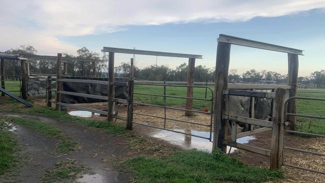
But the storm well and truly tore through 4 Mile Farm at Bouldercombe, with roofing ripped off one of the property’s yards like a tuna can lid.
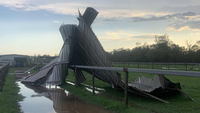
“I hope our horses like open plan living. That storm was full of hail, wind and anger,” a post on the business’ Facebook page said.
“Unfortunately It took out the wagon wheel roof and made a complete mess of the farm and complex and stable area so unfortunately there no sessions here tomorrow until I tidy up.
“We are all safe here, just a bit flat and not looking forward to a cyclone if this is what a storm just did.”
Bureau of Meteorology community information officer Daniel Hayes said the storm activity was caused by an upper level trough moving through the southern parts of Queensland.
“It did push some influence towards the Rockhampton area and the Central Highlands and Coalfields area as well, so we had severe thunderstorm warnings out for those areas,” he said.
“Around the Rocky area we definitely had in that warning the potential for large hailstones and strong winds, we haven’t actually seen any reports or large hail up around the Rocky area.
“As far as the winds go, the strongest wind gust we had reported at the Rockhampton Airport site was about 57km/h, but the radar did indicate some activity just south of Rockhampton it seems as it came into Rocky it weakened a little.”
FUNNEL CLOUD FORMS
After Monday afternoon’s storm activity, many locals were left scratching their heads when a funnel cloud was seen in the sky.
The phenomenon was seen from Gracemere and Rockhampton Airport.
Mr Hayes said a funnel cloud is formed in about the same way as a tornado, but without the storm behind it.
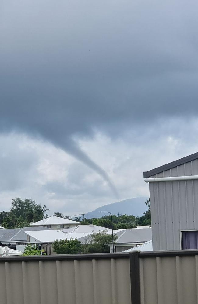
“Basically we’ve had convective cloud where you’re getting that air lifted up into the cloud allowing it to form, and you can get some rotation inside of that,” he explained.
“If it’s strong enough you can get a funnel cloud to form off the bottom of the cloud and it could touch down on the ground.
“We didn’t have any thunderstorms around this morning so any funnel cloud that was there, even if it were to touch down, it would have been quite weak and we certainly haven’t seen any reports of damage or anything.”
CYCLONE SEASON BEGINS
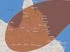
With the potential of storm activity heading north, Rockhampton residents wait with bated breath to see if a tropical low likely to become a cyclone by Tuesday night will impact the region.
BoM confirmed the tropical low will form into the first cyclone of the season on Tuesday afternoon in the Solomon Sea before it moves into the Coral Sea later in the week.
Once formed, it will be known as Tropical Cyclone Jasper.
The system is expected to develop into a severe cyclone by Wednesday night and will travel towards the Queensland coastline.
But where and if it makes landfall is still unknown.
The Bureau had initially forecast direct impacts on Queensland were unlikely, but that outlook has changed in the past 24 hours.
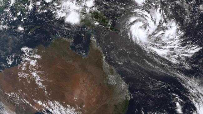
“It’s moving into an area that’s quite favourable for its development, so over the course of the next few days it is expected to develop into a severe tropical cyclone, Category 3 and even Category 4 by the end of the week,” Mr Hayes said.
“It’s got quite a move on as far as development is going, but even by the end of the week it will still be a long way from the Queensland coast and as we head through the weekend and to the end of the weekend it would seem there is still a bit of uncertainty as to the actual movements of the system.
“How close it will come to the Queensland coast, if it will cross and exactly where that might be and, indeed, exactly how strong it might still be as it approaches the coast.
“It does seem that there is potentially some more unfavourable conditions as it moves towards the Queensland coast.”
Mr Hayes said early modelling showed that Tropical Cyclone Jasper could come towards the Central Queensland coast or the Northern Queensland coast, but also had the cyclone heading anywhere between Cairns and Brisbane.


North Mackay man, 45, killed in motorcycle 12 hours after triple fatal crash
A 45-year-old motorbike rider has been killed in the same Qld region where three teenagers tragically died in another crash just hours earlier. *Distressing.

One lane closed on busy Central Qld road after crash
A lunchtime crash in Rockhampton, has led to the closure of one lane, causing delays for motorists.