
Qld weather: Experts predict cyclone could bring more wet weather during school holidays
Major flooding was expected at Boonah southwest of Brisbane on Monday afternoon, after heavy downpours overnight that also caused closed highways and prompted emergency alerts for parts of the Darling Downs.
QLD News
Don't miss out on the headlines from QLD News. Followed categories will be added to My News.
Two highways have been closed on the Darling Downs after storms and heavy rain overnight caused flash flooding, with emergency alerts issued for areas south of Toowoomba.
The Leichhardt Highway is shut at Condamine due to flash flooding in the area.
The latest emergency alert for flash flooding is for Leyburn in the Southern Downs Region.
Rain bucketed down overnight in the Darling Downs region along the northern NSW border with Yangan copping 113mm in the 24 hours to 9am this morning, while 111mm was recorded at both Wilsons Peak and Spicers Peak.
Severe thunderstorms continue to be possible in the southeast interior with the Bureau of Meteorology warning residents in areas including St George, Goondiwindi, Warwick and Stanthorpe to be cautious of damaging wind gusts, large hail and heavy rain.
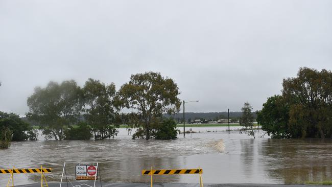
A major flood warning has also been issued for Boonah, 100km inland of the Gold Coast.
The Bureau of Meteorology has warned after rainfall of up 95mm overnight, flooding is likely in the upper Teviot Brook and Logan catchments this afternoon.
River level rises and localised flooding is expected along the upper Logan River to Yarrahappini with major flooding expected at Boonah this afternoon.
.
Earlier, an emergency alert was issued for Killarney and Allora, with residents urged to stay up to day with warnings and avoid driving where possible.
Police shut the New England Highway and surrounding roads in Allora and Clintonville, with no local diversions in place, due to the heavy rainfall.
Motorists have been urged to avoid driving through flood waters or surrounding areas.
Meanwhile, the Bureau also put in place a major flood warning for both the Condamine and Balonne Rivers early this morning with peaks already reaching almost 12m at Chinchilla Weir
Heavy rainfall on Sunday night saw totals of up to 90mm with the major flood peak expected at Condamine Township, 200km northeast of Toowoomba, today.
Major flooding is also expected along the Condamine River, downstream from Loudoun Bridge, as well as in the upper Balonne River at Warkon, with minor flooding also rising between Surat and Weribone.
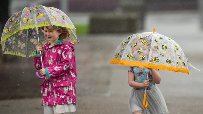
Thunderstorms and showers are expected to continue throughout the day.
The band of rain will soon also make its way over to southeast Queensland later in the week with BOM meteorologist Livio Regano saying showers are likely.
Queenslanders are being warned a late-season cyclone is still likely to form over the Coral Sea this week, delivering the potential for wild weather as the school holidays get under way.
Head of Brisbane Weather, David Taylor has been watching the weather activity in the Coral Sea closely on the Global Forecast System.
“There will be one, possibly two systems that will develop into a cyclone, it just boils down to timing.” Mr Taylor said.
The Bureau of Meteorology confirmed a cyclone is likely to develop close to New Caledonia then move to the far east Coral Sea.
The Bureau said a cyclone will most likely form, but the threat of it coming anywhere close to Australia has backed off.
“There could be a cyclone by Wednesday or Thursday but it will be in the Fiji waters and far away from us,” Mr Regano said.
“It will increase the size of the swell on the eastern beaches however from Thursday.”
Despite that, the weather system in the Coral Sea is still likely to generate larger swells and increase the likelihood of wet weather and wild surf conditions along the Queensland coast.
From Wednesday a trough through the southeast interior will become more active, aided by an easterly flow and an upper feature which will increase the chance of showers from Thursday.
“Tomorrow will be fine and sunny with the weather deteriorating throughout the week. There is expected to be some showers hitting us by Thursday or Friday,” Mr Regano said.
With a low north of New Caledonia that could drift southward and remain over the far east of the Coral Sea, wet conditions are also predicted this weekend.
“Increased shower activity and potentially hazardous surf conditions above the south east are expected next weekend,” Bureau of Meteorology forecaster, Felim Hannify said.


The big banking mistake many of us make, generation after generation
Almost one in three Australians, are committing this error when banking and it could be seriously affecting your finances.

Seven days of heartbreak: State reels as road toll spirals
Queensland has posted a staggering 16 road deaths in just seven days, with warnings it is on track for a record annual toll.