
GPS leading drivers into notorious bridge crash zone
ADELLE Walsh was driving from her Sunshine Coast home with a friend to pick up a new car in Gladstone when she came across a terrible sight.
Gympie
Don't miss out on the headlines from Gympie. Followed categories will be added to My News.
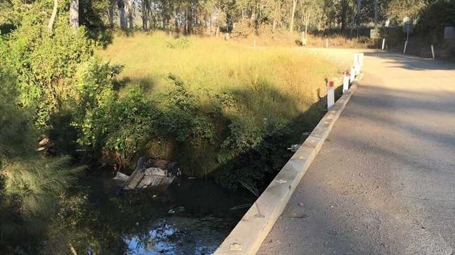
THE winding Brooweena-Woolooga Rd is partly dirt, with some stretches of single-lane bitumen, and runs across the notorious Running Creek Bridge.
Yet GPS systems are still listing the stretch as a main road, leading unsuspecting drivers into danger.
Adelle Walsh was driving from her Sunshine Coast home with a friend to pick up a new car in Gladstone when she came across a terrible sight.
She was crossing Woolooga's Running Creek Bridge just before 7am on Saturday, a road she had never been on but had been directed to follow by her GPS, when she saw two women and two children toddling along the end of the bridge, drenched and blood streaked.
"They were all wet and one woman had blood down the side of her face and she was holding a three year old," Ms Walsh said.
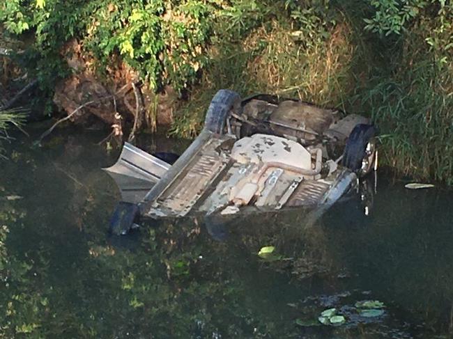
Just minutes before, Gladstone woman Erica Morris, her friend and her daughters Syndal, 3, and Alexiah, 5, and had careened off the bridge in their car and flipped upside down into the water.
READ HOW THE STORY UNFOLDED
- 'She wasn't breathing and my mind just shut down'
- Call for action on bridge after near tragedy
- LETTER: Fix Gympie region's dangerous bridges
After a struggle to free the children from their car restraints, the women in the crash revived the three year old.
"I just can't believe how lucky they are, when you look at the photo it looks like there's air in the cabin, but they were upside down and the car would have filled with water quickly," Ms Walsh said.
Ms Walsh called an ambulance just before more people arrived and was able to offer first aid and blankets.
Ms Morris said the struggle to free Syndal from her seatbelt was the most terrifying experience of her life.
"It wouldn't come undone when I first tried, so I had to come back up and go back down," Ms Morris said.
"Each time that I came up for air, all that was going through my head was, 'Oh my god, she's going to die, she's going to die because it's taking me so long to get her out.'"
Ms Morris, unfamiliar with the area, had been following the Google Maps GPS on her phone before the crash on their way from Gladstone to Deception Bay.
The GPS directed her off the Bruce Hwy and onto Brooweena-Woolooga Rd before she lost traction at the bridge.
Ms Walsh was worried GPS systems were directing people to drive along the road as the shortest route.
She said an accident can happen easily when drivers are not familiar with the road and the state of the bridge on Brooweena-Woolooga Rd.
"The GPS took us that way. I used to live in Imbil so I'm quite used to driving those sort of roads, but I can see how (if you're not) it would be a big risk for people."
"We didn't realise that it wasn't a main road - it turns to dirt, but the GPS has it listed as a highway."
It's a complaint been made by Woolooga residents before. They are all too familiar with the sight of vehicles in the creek, and have voiced concerns about navigation systems leading unsuspecting travellers over the dangerous bridge.
Ms Morris said more accidents will happen if GPS system information isn't fixed.
"When you're not a local and this is where the GPS keeps sending you, we're not going to know the road conditions," she said.
She said she doesn't want anyone to suffer the same experience.
"It was the most terrifying thing I've done and I don't want anyone to go over there and end up dying," she said.
There might not be any quick solution to changing GPS systems, but Ms Walsh said something needed to be done about the bridge.
"I think in the absolute minimum the approaches need to be fully sealed and proper small guard rails should be added, which would stop most small cars," she said.
Ms Morris agreed the structure needed urgent attention.
"They need barriers on that bridge, and they need more warning," she said.
"If that's happened before, why wasn't it fixed to begin with?"
Death by GPS
Lorraine Sommerfeld of Canadian website Driving said the saying 'Death by GPS' is not a rumour. She said many satellite systems are still recognizing bypasses that have been closed for decades as roads, and also listing smaller roads as major detours.
There have been a number of severe accidents worldwide, where drivers have been put in dangerous situations by following their navigation systems. Shockingly, some have resulted in death.
April 2015: A Chicago woman, Zohra Hussain, died when her husband, while following GPS instructions, attempted to cross a bridge that had been closed since 2009. Hussain died of burns after the subsequent 11 metre plunge.
2012: three Japanese tourists in Australia had to abandon the car they were driving on a road that got progressively muddier; the GPS hadn't warned them the road would be under water at high tide, and they scrambled to get out as it floated away.
2011: three women in Washington State ended up in a submerged SUV when they blindly followed the GPS in their rental. They escaped injury.
2009: Alicia Sanchez was found near death by a ranger, her young son dead in her Jeep. Lost for five days in the unforgiving temperatures that can climb over 46 degrees Celsius in summer months, she'd followed GPS instructions off established roads and deeper into uncharted territory.
2007: A German truck driver got stuck in a Swiss cherry tree. He followed the voice, he said.

Keith Pitt made Ambassador to the Holy See in shock announcement
Outgoing Federal MP for Hinkler Keith Pitt announced he would exit politics late last year citing “frustration” and policy disagreements, and hinted at the time that an undisclosed new job opportunity was among the reasons for his decision. Now we know what that was.
‘Heard gunshots, then sirens’: Mystery deepens after property lockdown
Neighbours have described what they heard before police swarmed a rural Qld property and eerie recent history has emerged despite limited information coming from authorities. LATEST.