
Calm before the storms as more wild weather predicted for Tuesday
A severe thunderstorm warning has been issued for parts of north Queensland. It comes after predictions of very dangerous storms in southeast Queensland tomorrow. SEE THE LATEST FORECASTS

QLD News
Don't miss out on the headlines from QLD News. Followed categories will be added to My News.
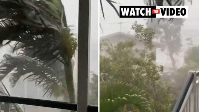
A severe thunderstorm warning has been issued for parts of north Queensland this evening, with damaging winds likely.
Parts of Herbert and Lower Burdekin were told to prepare for the storms in the warning, which was issued at 6.21pm.
It comes after the Bureau of Meteorology earlier warned that severe storms were likely from the Sunshine Coast to Mackay by mid-afternoon, while very dangerous storms are possible tomorrow.
ðŸŒ©ï¸ Very dangerous storms possible Tuesday, with severe storms forecast for large parts of eastern and northern #Qld. Now is the time to prepare your home for the possibility of damaging to destructive wind gusts, large to giant hail and heavy to intense rainfall. #QldStorm pic.twitter.com/4od1GKoldm
— Bureau of Meteorology, Queensland (@BOM_Qld) October 26, 2020
BOM’s forecast for tomorrow states that very dangerous storms were possible Tuesday from southeast Queensland to Mackay, with severe storms forecast for large parts of the state’s east and north.
“Now is the time to prepare your home for the possibility of damaging to destructive wind gusts, large to giant hail and heavy to intense rainfall.”
ðŸŒ©ï¸ An active week of Thunderstorms for #Qld continues, with severe thunderstorms possible across far eastern Queensland today (Monday). Severe thunderstorms are most likely south of Mackay and north of the Sunshine Coast from mid-afternoon. pic.twitter.com/NOu4fhtQvY
— Bureau of Meteorology, Queensland (@BOM_Qld) October 26, 2020
Earlier, the Bureau of Meteorology’s James Thompson told The Courier-Mail that forecasters did not expect a repeat of the weekend’s destructive storms today, but that severe storms could return Tuesday and Wednesday.
Any heavy rain today is expected to be north of the Sunshine Coast.
“For the far southeast most of it has moved offshore but there is the lingering chance of a shower, even the slight chance of a storm today, most of it is going to be further north,” he said.
Man seriously hurt, power out until Monday after storm chaos
LIVESTREAM WATER POLO: Queensland Premier League round 3-4 from Valley Pool
“Around Brisbane today we’re not forecasting severe thunderstorms which is what we saw through Sunday but on Tuesday and Wednesday we are looking at a significant chance of severe thunderstorms for southeast Queensland as well as other parts of eastern Queensland.”
He said the first half of the week was expected to have reasonably active storms.
“The storms are most likely to pick up through the afternoon on Tuesday, from late morning and into the evening is our best chance for thunderstorms.”
“With the moisture that we have around it’s not uncommon to see any time of day a shower or even the odd thunderstorm.”
“There is quite a bit of extra moisture with a trough that is lying just inland of the Queensland coast, dragging in that tropical moisture into eastern Queensland as well as a combination of some upper troughs moving through the area over the next couple of days.”
The forecast for more severe storms follows a destructive weekend in which Australia was hit by more than 2.24 million lightning strikes in just 48 hours, with the majority of these recorded in Queensland.
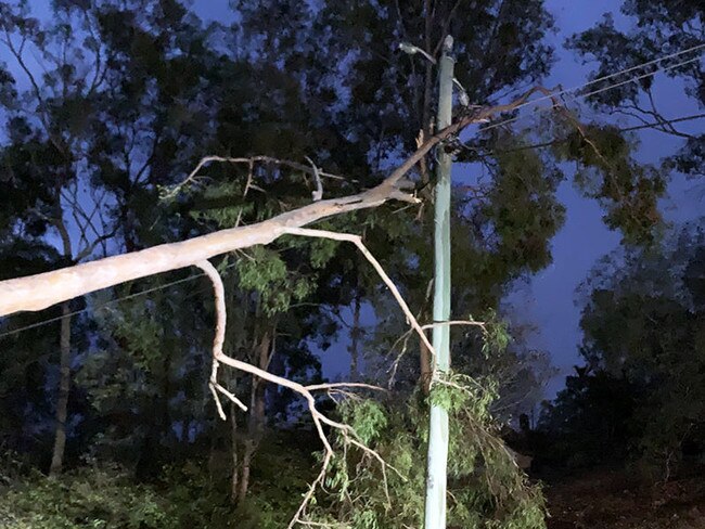
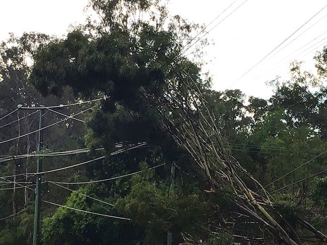
In Queensland, the SES, Rural Fire Service, and Queensland Fire and Emergency Services crews were called to 220 jobs for fallen trees, fallen powerlines and property damage, while as of 8.15am on Monday 1,850 Energex customers remained without power.
RACQ meanwhile had already received 174 insurance claims by 9am Monday from the destructive storm, with more than 80 per cent of those due to home damage.
RACQ spokeswoman Lucinda Ross said Sunday’s event set the scene for what was expected to be a wet and destructive storm season.
“We’ve seen hail, strong winds and torrential rain cause serious damage across the region and our claims numbers are only going to rise as our members take stock of any damage they may have,” she said.
“The worst regions we’ve seen are Karalee and Karana Downs, Bayside and Brassal, with more than 50 claims between these areas.”
“We’ve seen damaged roofs from fallen trees, hail damaged windows and vehicles and minor flooding.”
She said the damage from over the weekend was from cars being left outside, windows open or unsecured outdoor items.
“Make sure you and all members of your household know exactly what needs to be done if a severe storm is forecast so you can protect your property and your family.”
Meanwhile, Energex are working to repair power in areas where lightning and fallen trees wiped out entire areas of the network.
Chuwar, Karana Downs, Pine Mountain, Karalee Tivoli, Mt Crosby and North Ipswich were still being affected by power outages on Friday morning.
“We’re also repairing outages affecting people at Macleay Island, Sunnybank Hills and Thornlands as well as smaller pockets of damage,” Energex wrote on social media.
“Overnight, crews restored the bulk of customers in and around Redland Bay and in the southern suburbs, with 16,000 customers resupplied since midnight.”
“Yesterday’s storms clocked more than 190,000 lightning strikes and took down more than 200 sections of powerlines.”
Brisbane has recorded almost 34mm of rain since 9am on Sunday, while Oakey near Toowoomba received 42.6mm.
At least 34 homes in southeast Queensland were impacted by flooding, mostly from leaking roofs caused by heavy rainfall, with Ipswich, South Brisbane, Redlands and Logan the most affected areas.
A QFES spokeswoman said 132 jobs were for structural damage to houses and 99 for fallen trees, with crews still responding to 33 requests for assistance as of 6am on Monday.