
Brisbane residents put on alert ahead of bushfire season
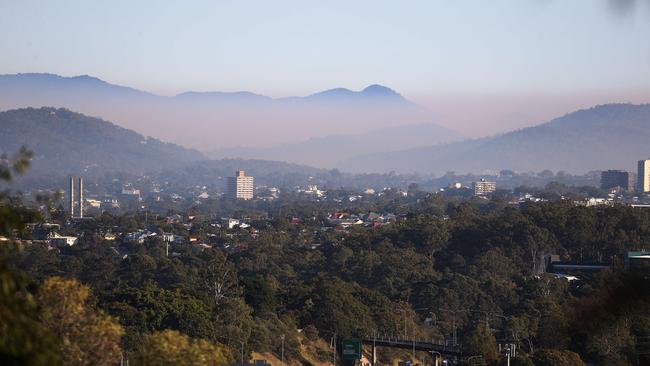
As areas to the north were blanketed in smoke from a bushfire, residents of 26 Brisbane suburbs have been warned of a dire fire season ahead. SEE WHERE

QLD News
Don't miss out on the headlines from QLD News. Followed categories will be added to My News.
Residents north of Brisbane have been warned to stay indoors as a bushfire blankets multiple suburbs in smoke.
Queensland Fire and Emergency Services issued an alert on Thursday morning for those in Griffin, North Lakes, Deception Bay and Redcliffe to stay inside and close windows and doors.
The smoke was coming from a bushfire burning in the Griffin Environmental Reserve and was potentially harmful, particularly to those with existing respiratory problems.
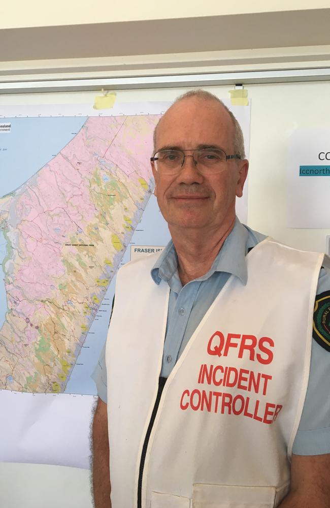
QFES Superintendent James Haig said that as Queensland entered bushfire season it was imperative at-risk residents had a survival plan.
“It’s been less bushfires up here than perhaps down south, but of course we are seeing changing situations with the climate and migration, so people do need to be aware of their local risk,” he said.
“It’s really important that people do that planning in advance because it’s much easier to make decisions in that sort of considered way than to communicate with your family as a bushfire occurs when you least expect it.”
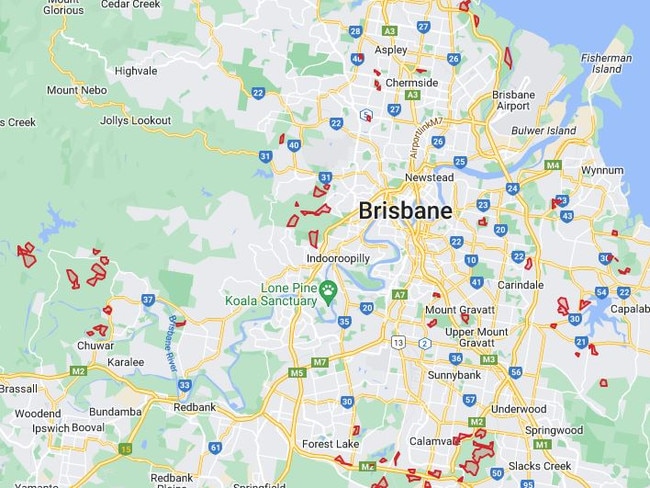
Thursday morning’s alert comes after Brisbane City Council issued thousands of warning letters across 26 fire-prone suburbs, telling locals to brace for a potentially fierce bushfire season.
Just weeks after thick smoke from hazard-reduction burns choked the city, council said it would conduct more burn-offs to reduce fire fuel ahead of summer as part of their bushfire management plan.
Lord Mayor Adrian Schrinner said eight extra burns were planned for 2023 after the Bureau of Meteorology confirmed an El Nino weather system was likely to develop in late winter or early spring.
“To date, we have completed eight more burns than 2022 and, weather permitting, will complete more burns across suitable sites,” Mr Schrinner said.
QFES issued a further two smoke warnings on Thursday from hazard reduction burns at Bunyaville Conservation Park, in Brisbane’s northwest, and North Stradbroke Island (Minjerribah) near East Coast Road.
Supt Haig said that hazard reduction burns were an imperative mitigation tool around suburbs with high bushfire risk, such as being near grassy slopes.
“The smoke impacts, of course, that‘s not at all the intention of these prescribed burns or these hazard reduction burns, it’s an unfortunate consequence,” he said.
“But as we‘ve seen before if you have a bushfire itself also generates heaps of smoke. So we would much rather try and do it in a controlled way when we can keep the people safe and minimise the risk going into the season itself.”
A QFES spokesman said while hazard reduction burns could be scheduled for a nominated time period, it was not possible to provide definitive start and duration dates as controlled burns were dependent on a number of factors, specifically weather conditions.
Supt Haig said another imperative bushfire mitigation effort was residents preparing their own properties by clearing gutters and yards of potential fuel.
Supt Haig said El Nino would increase the likelihood of drought conditions furthering the risk of bushfires as warmth increases and rain reduces.
“Another thing is making sure that the access isn’t overgrown, so that should you need to leave you can do so easily,” he said,
“And secondly, so that we would if we need to, get in with one of our fire trucks.”
LIST OF BRISBANE HAZARD REDUCTION BURNS
7th Brigade Park, Chermside
This burn is located in 7th Brigade Park in bushland along Delaware Street, Geebung.
Reserve: 7th Brigade Park
Locality: This burn is located in 7th Brigade Park in bushland along Delaware Street, Geebung.
Block: 2 and 3
Area: 7.2ha
Additional information: Local residences and the Kidspace Playground may be affected by smoke.
Anstead Bushland Reserve, Anstead
This burn is located in Anstead Bushland Reserve between Hawkesbury Road and the Brisbane River.
Reserve: Anstead Bushland Reserve
Locality: This burn is located in Anstead Bushland Reserve between Hawkesbury Road and the Brisbane River.
Block: 4
Area: 10.8ha
Additional information: Smoke may impact local residences and settle in surrounding areas overnight. Tracks around the burn area may be closed for up to two weeks following the burn.
Beaudesert Road Park, Parkinson
This burn is located in Beaudesert Road Parklands between the Logan Motorway, Watarrka Drive and Gibraltar Circuit, Parkinson.
Reserve: Beaudesert Road Park
Locality: This burn is located in Beaudesert Road Parklands between the Logan Motorway, Watarrka Drive and Gibraltar Circuit, Parkinson.
Block: 1
Area: 7.6ha
Additional information: Smoke may impact local residences and the Logan Motorway and settle in surrounding areas overnight.
Belmont Hills Bushland, Carindale
This burn is located in Belmont Hills Bushland between Old Cleveland Road and Ewer Street on the western side of the power easement.
Reserve: Belmont Hills Bushland
Locality: This burn is located in Belmont Hills Bushland between Old Cleveland Road and Ewer Street on the western side of the power easement.
Block: 7, 9 and 11
Area: 21.2ha
Additional information: Smoke may impact local residences and settle in surrounding areas overnight. Tracks in the vicinity will be closed for up to two weeks after the burn.
Old Cleveland Road and the Gateway Motorway may be affected by smoke.
Blunder Creek Reserve, Doolandella
This burn is located in Blunder Creek Reserve between Brookside Street, Westminster Boulevard and Blunder Creek.
Reserve: Blunder Creek Reserve
Locality: This burn is located in Blunder Creek Reserve between Brookside Street, Westminster Boulevard and Blunder Creek.
Block: 2 & 2A
Area: 15.6ha
Additional information: Smoke may impact local residences and settle in surrounding suburbs overnight. Tracks around the burn area will be closed for up to two weeks after the burn.
Boondall Wetlands, Boondall
This burn is located in Boondall Wetlands east of the Boondall Wetlands bikeway and south of the Boondall Wetlands Environment Centre.
Reserve: Boondall Wetlands
Locality: This burn is located in Boondall Wetlands east of the Boondall Wetlands bikeway and south of the Boondall Wetlands Environment Centre.
Block: 12
Area: 14.0ha
Additional information: Smoke may affect the Gateway Motorway and settle in surrounding suburbs overnight. The Boondall Wetlands bikeway will be closed for the duration of the burn and up to two weeks after the burn.
Boondall Wetlands, Boondall
This burn is located in the northern end of Boondall Wetlands between Paperbark Drive and Cabbage Tree Creek.
Reserve: Boondall Wetlands
Locality: This burn is located in the northern end of Boondall Wetlands between Paperbark Drive and Cabbage Tree Creek.
Block: 6
Area: 6.5ha
Additional information: Smoke may impact on Gateway Motorway and settle in surrounding areas overnight.
Boondall Wetlands, Boondall
This burn is located in the northern end of Boondall Wetlands between the Gateway Motorway and Paperbark Drive.
Reserve: Boondall Wetlands
Locality: This burn is located in the northern end of Boondall Wetlands between the Gateway Motorway and Paperbark Drive.
Block: 1, 2, 3 and 4
Area: 28.0ha
Additional information: Smoke may impact on Gateway Motorway and settle in surrounding areas overnight.
Brighton Wetlands, Brighton
This burn is located in Brighton Wetlands Goodenia Reserve between Saul Street, Northcote Street and Maclean Street, Brighton.
Reserve: Brighton Wetlands Goodenia Reserve
Locality: This burn is located in Brighton Wetlands Goodenia Reserve between Saul Street, Northcote Street and Maclean Street, Brighton.
Block: 20 & 21
Area: 4.3ha
Additional information: Smoke may impact local residences and settle in surrounding areas overnight. Tracks in the reserve may be closed for up to two weeks after the burn.
Brisbane Koala Bushlands, Alperton Road Park, Burbank
This burn is located in Brisbane Koala Bushlands to the west of Alperton Road.
Reserve: Brisbane Koala Bushlands – Alperton Road. Park
Locality: This burn is located in Brisbane Koala Bushlands to the west of Alperton Road.
Block: 1A
Area: 4.9ha
Additional information: Smoke may impact local residences and settle in surrounding areas overnight.
Brisbane Koala Bushlands, Longton Court Park, Burbank
This burn is located in Brisbane Koala Bushlands between Longton Court and the power easement.
Reserve: Brisbane Koala Bushlands – Longton Court Park
Locality: This burn is located in Brisbane Koala Bushlands between Longton Court and the power easement.
Block: 1B, 2A-C
Area: 17.0ha
Additional information: Smoke may impact local residences and settle in surrounding areas overnight. Tracks around the burn area may be closed for up to two weeks after the burn.
Brisbane Koala Bushlands, Leacroft Road Park, Burbank
This burn is located in Brisbane Koala Bushlands between Mt Cotton Road, Alperton Road and Stockyard Creek, Burbank.
Reserve: Brisbane Koala Bushlands, Leacroft Road Park.
Locality: This burn is located in Brisbane Koala Bushlands between Mt Cotton Road, Alperton Road and Stockyard Creek, Burbank.
Block: 1
Area: 18ha
Additional information: Smoke may impact local residences and settle in surrounding areas overnight. Tracks in the vicinity will be closed during the burn and may remain closed for up to two weeks after the burn.
Brisbane Koala Bushlands, Prout Road Park, Burbank
This burn is located to the east of Prout Road in Burbank.
Reserve: Brisbane Koala Bushlands, Prout Road Park
Locality: This burn is located to the east of Prout Road in Burbank.
Block: 1 & 1A
Area: 38.2ha
Additional information: Smoke may impact local residences and settle in surrounding areas overnight. Tracks around the burn area may be closed for up to two weeks following the burn.
Brisbane Koala Bushlands, Prout Road Park, Burbank
This burn is located to the east of Prout Road in Burbank.
Reserve: Brisbane Koala Bushlands, Prout Road Park
Locality: This burn is located to the east of Prout Road in Burbank.
Block: 1, 1A, 4 & 5
Area: 27.0ha
Additional information: Smoke may impact local residences and settle in surrounding areas overnight. Tracks around the burn area may be closed for up to two weeks following the burn.
Changing Mountain Bushland, Kholo
This burn is located in Changing Mountain Bushland along Lake Manchester Road.
Reserve: Changing Mountain Bushland
Locality: This burn is located in Changing Mountain Bushland along Lake Manchester Road.
Block: 21
Area: 22.7ha
Additional information: Smoke may impact local residences and settle in surrounding areas overnight. Tracks in the vicinity of the burn area will be closed during the burn and may be closed for up to two weeks after the burn.
Changing Mountain Bushland, Kholo
This burn is located to the south of Lake Manchester Road, Kholo.
Reserve: Changing Mountain Bushland
Locality: This burn is located to the south of Lake Manchester Road, Kholo.
Block: 11 & 12
Area: 46.0ha
Additional information: Smoke may impact local residences and settle in surrounding areas overnight. Tracks around the burn area may be closed for up to two weeks following the burn.
Changing Mountain Bushland, Kholo
This burn is located to the south of Lake Manchester Road, Kholo.
Reserve: Changing Mountain Bushland
Locality: This burn is located to the south of Lake Manchester Road, Kholo.
Block: 13
Area: 40.3ha
Additional information: Smoke may impact local residences and settle in surrounding areas overnight. Tracks around the burn area may be closed for up to two weeks following the burn.
Changing Mountain Bushland, Kholo
This burn is located to the south of Lake Manchester Road, Kholo.
Reserve: Changing Mountain Bushlands
Locality: This burn is located to the south of Lake Manchester Road, Kholo.
Block: 7
Area: 42.6ha
Additional information: Smoke may impact local residences and settle in surrounding areas overnight. Tracks around the burn area may be closed for up to two weeks following the burn.
Changing Mountain Bushland, Kholo
This burn is located in Changing Mountain Bushland between Lake Manchester Road and Stumers Road.
Reserve: Changing Mountain Bushland
Locality: This burn is located in Changing Mountain Bushland between Lake Manchester Road and Stumers Road.
Block: 15
Area: 17.2ha
Additional information: Smoke may impact local residences and settle in surrounding areas overnight. Tracks in the vicinity of the burn area will be closed during the burn and may be closed for up to two weeks after the burn.
Chelsea Road Park, Ransome
This burn is located on the corner of Chelsea Road and Rickert Road Ransome.
Reserve: Chelsea Road Park
Locality: This burn is located on the corner of Chelsea Road and Rickert Road Ransome.
Block: 7
Area: 8.8ha
Additional information: Smoke may impact local residences and settle in surrounding areas overnight. Smoke may impact Chelsea Road and Rickert Road Ransome.
Dandy‘s Range Bushland, Kholo
This burn is located in Dandy‘s Range Bushland along Lake Manchester Road.
Reserve: Dandy‘s Range Bushland
Locality: This burn is located in Dandy‘s Range Bushland along Lake Manchester Road.
Block: 3
Area: 9ha
Additional information: Smoke may impact local residences and settle in surrounding areas overnight. Tracks around the burn area may be closed for up to two weeks after the burn.
Drewvale Bushland, Drewvale
This burn is located in Drewvale Bushlands behind residences along Trinity Way and Randwick Place.
Reserve: Drewvale Bushlands
Locality: This burn is located in Drewvale Bushlands behind residences along Trinity Way and Randwick Place.
Block: 1
Area: 12.2ha
Additional information: Smoke may impact local residences and settle in surrounding suburbs overnight. Tracks around the burn area will be closed for up to two weeks after the burn.
Glider Forest, Larapinta
This burn is located in Glider Forest along Paradise Road, Larapinta
Reserve: Glider Forest
Locality: This burn is located in Glider Forest along Paradise Road, Larapinta
Block: 3
Area: 29.1ha
Additional information: Smoke may impact local residences and settle in surrounding areas overnight. Tracks in the vicinity will be closed during the burn and may remain closed for up to two weeks following the burn.
Habitat Estate, Fiddlewood Place Park, McDowall
This burn is located behind residences on Fiddlewood Place, Brookleaf Place, Ironbark Place and Arbour Street, McDowall.
Reserve: Habitat Estate, Fiddlewood Place Park
Locality: This burn is located behind residences on Fiddlewood Place, Brookleaf Place, Ironbark Place and Arbour Street, McDowall.
Block: 1-3
Area: 2.5ha
Additional information: Smoke may impact local residences and settle in surrounding areas overnight.
Hemmant Quarry Reserve, Tingalpa
This burn is located in Hemmant Quarry Reserve at the junction of Fleming Road and Wynnum Road.
Reserve: Hemmant Quarry Reserve
Locality: This burn is located in Hemmant Quarry Reserve at the junction of Fleming Road and Wynnum Road.
Block: 1
Area: 5.1ha
Additional information: Smoke may impact local residences and settle in surrounding areas overnight. Tracks in the vicinity will be closed for up to two weeks after the burn. Wynnum Road and Fleming Road may be affected by smoke.
Hemmant Quarry Reserve, Tingalpa
This burn is located in Hemmant Quarry Reserve between Fleming Road and Wynnum Road, Tingalpa.
Reserve: Hemmant Quarry Reserve
Locality: This burn is located in Hemmant Quarry Reserve between Fleming Road and Wynnum Road, Tingalpa.
Block: 3 & 4
Area: 10.7ha
Additional information: Smoke may impact local residences and settle in surrounding areas overnight. Tracks in the vicinity will be closed for up to two weeks after the burn. Wynnum Road and Fleming Road may be affected by smoke.
Hinchinbrook Circuit Park and Woogaroo Reserve, Heathwood
This burn is located in bushland between the Logan Motorway, Sanctuary Drive, Cooloola Lane, Parkside Place and Piccadilly Place, Heathwood.
Reserve: Hinchinbrook Circuit Park and Woogaroo Reserve.
Locality: This burn is located in bushland between the Logan Motorway, Sanctuary Drive, Cooloola Lane, Parkside Place and Piccadilly Place, Heathwood.
Block: 2
Area: 21.4ha
Additional information: Smoke may impact local residences and settle in surrounding areas overnight.
Karawatha Forest South, Drewvale
This burn is located in Karawatha Forest Park South between the Gateway Motorway and Illaweena Street.
Reserve: Karawatha Forest South
Locality: This burn is located in Karawatha Forest Park South between the Gateway Motorway and Illaweena Street.
Block: 28
Area: 5.9ha
Additional information: Smoke may impact local residences and settle in surrounding areas overnight. Smoke may affect the Gateway Motorway.
Karawatha Forest South, Drewvale
This burn is located in Karawatha Forest South between the Logan Motorway, Beaudesert Road, Plumeria Place, Tamarisk Way and the Gateway Motorway, Drewvale.
Reserve: Karawatha Forest South
Locality: This burn is located in Karawatha Forest South between the Logan Motorway, Beaudesert Road, Plumeria Place, Tamarisk Way, Waterbrooke Circuit and the Gateway Motorway, Drewvale.
Block: 30
Area: 26.6ha
Additional information: Smoke may impact local residences and settle in surrounding areas overnight.
Karawatha Forest West, Stretton
This burn is located in Karawatha Forest West between the Gateway Motorway, Yorkeshire Place and Kardella Street.
Reserve: Karawatha Forest West
Locality: This burn is located in Karawatha Forest West between the Gateway Motorway, Yorkeshire Place and Kardella Street.
Block: 18
Area: 17ha
Additional information: Smoke may impact the Gateway Motorway and local residences and settle in surrounding suburbs overnight. Tracks around the burn area will be closed for up to two weeks after the burn.
Karawatha Forest, Karawatha
This burn is located in Karawatha Forest between the Wallaby Track, Entolasia Track, Rocks Track and Brushtail Track.
Reserve: Karawatha Forest
Locality: This burn is located in Karawatha Forest between the Wallaby Track, Entolasia Track, Rocks Track and Brushtail Track.
Block: 6A & 6B
Area: 49.5ha
Additional information: Smoke may impact local residences and settle in surrounding areas overnight. The Wallaby Track, Entolasia Track, Rocks Track and Brushtail Track will be closed during the burn and may be closed for up to two weeks after the burn.
Karawatha Forest, Karawatha
This burn is located in Karawatha Forest between Compton Road, the Entolasia Trail and Echidna Track.
Reserve: Karawatha Forest
Locality: This burn is located in Karawatha Forest between Compton Road, the Entolasia Trail and Echidna Track.
Block: 3A
Area: 27ha
Additional information: Smoke may impact Compton Road and local residences and settle in surrounding suburbs overnight. The Entolasia Trail and Echidna Track will be closed for the duration of the burn and may remain closed for up to two weeks after the burn.
Karawatha Forest, Karawatha
This burn is located in Karawatha Forest between Wallaby Track, Dianella Track, Banksia Trail, Wallum Trail and Brushtail Track.
Reserve: Karawatha Forest
Locality: This burn is located in Karawatha Forest between Wallaby Track, Dianella Track, Banksia Trail, Wallum Trail and Brushtail Track.
Block: 9
Area: 94ha
Additional information: Smoke may impact local residences and settle in surrounding suburbs overnight and for a number of days after. The Wallaby Track, Dianella Track, Banksia Trail, Wallum Trail and Brushtail Track will be closed for the duration of the burn and may remain closed for up to two weeks after the burn.
Karawatha Forest, Karawatha
This burn is located in Karawatha Forest between the Maculata Track, Hakea Trail, Wild May Trail and Casuarina Trail.
Reserve: Karawatha Forest
Locality: This burn is located in Karawatha Forest between the Maculata Track, Hakea Trail, Wild May Trail and Casuarina Trail.
Block: 15
Area: 74ha
Additional information: Smoke may impact local residences and settle in surrounding areas overnight. The Maculata Track, Hakea Trail, Wild May Trail and Casuarina Trail will be closed during the burn and may be closed for up to two weeks after the burn.
Karawatha Forest West, Stretton
This burn is located in Karawatha Forest West between the Gateway Motorway and behind residences on Ponciana Crescent, Tulipwood Place, Tamarind Place, Cassia Place, Cedar Place, Golden Rain Place and Elderbury Place.
Reserve: Karawatha Forest West
Locality: This burn is located in Karawatha Forest between the Gateway Motorway and behind residences on Ponciana Crescent, Tulipwood Place, Tamarind Place, Cassia Place, Cedar Place, Golden Rain Place and Elderbury Place.
Block: 19
Area: 15ha
Additional information: Smoke may impact local residences and settle in surrounding areas overnight. Tracks in the vicinity of the burn area will be closed during the burn and may be closed for up to two weeks after the burn.
Kedron Brook Floodway, Nudgee Beach
This burn is located along Nudgee Road, Nudgee Beach.
Reserve: Kedron Brook Floodway
Locality: This burn is located along Nudgee Road, Nudgee Beach.
Block: 1-3
Area: 35ha
Additional information: Smoke may impact local residences and settle in surrounding areas overnight.
Keperra Bushlands, Keperra
This burn is located in Keperra Bushlands at the end of Levitt Road, Keperra.
Reserve: Keperra Bushlands
Locality: This burn is located in Keperra Bushlands at the end of Levitt Road, Keperra.
Block: 7
Area: 10.8ha
Additional information: Smoke may impact local residences and settle in surrounding areas overnight. Tracks in the vicinity of the burn area may be closed for up to two weeks post burn.
Marstaellar Road Reserve, Mt Crosby
This burn is located in Marstaellar Road Reserve between Marstaellar Road and the Brisbane River, Mt Crosby.
Reserve: Marstaellar Road Reserve
Locality: This burn is located in Marstaellar Road Reserve between Marstaellar Road and the Brisbane River, Mt Crosby.
Block: 5
Area: 10.8ha
Additional information: Smoke may impact local residences and settle in surrounding areas overnight.
Marstaellar Road Reserve, Mt Crosby
This burn is located in Marstaellar Road Reserve between Marstaellar Road and the Brisbane River, Mt Crosby.
Reserve: Marstaellar Road Reserve
Locality: This burn is located in Marstaellar Road Reserve between Marstaellar Road and the Brisbane River, Mt Crosby.
Block: 3
Area: 22.6ha
Additional information: Smoke may impact local residences and settle in surrounding areas overnight.
Marstaellar Road Reserve, Mt Crosby
This burn is located in Marstaellar Road Reserve between Marstaellar Road and the Brisbane River, Mt Crosby.
Reserve: Marstaellar Road Reserve
Locality: This burn is located in Marstaellar Road Reserve between Marstaellar Road and the Brisbane River, Mt Crosby.
Block: 9
Area: 8.8ha
Additional information: Smoke may impact local residences and settle in surrounding areas overnight.
Mensforth Bushland, Bracken Ridge
This burn is located in Mensforth Bushland between Quinlan Street, Childs Street and Carl Place, Bracken Ridge.
Reserve: Mensforth Bushland
Locality: This burn is located in Mensforth Bushland between Quinlan Street, Childs Street and Carl Place, Bracken Ridge.
Block: 1
Area: 5.8ha
Additional information: Smoke may impact local residences and settle in surrounding areas overnight. Smoke may impact on Gateway Motorway.
Milne Hill Reserve, Chermside West
This burn is located in Milne Hill Reserve between Tullylease Place and Castlehaven Close, Chermside West.
Reserve: Milne Hill Reserve
Locality: This burn is located in Milne Hill Reserve between Tullylease Place and Castlehaven Close, Chermside West.
Block: 1
Area: 4.8ha
Additional information: Smoke may impact local residences and settle in surrounding areas overnight. Tracks around the burn area may be closed for up to two weeks after the burn.
Mt Coot-tha Reserve, Bardon
This burn is located in the Bardon Section of Mt Coot-tha Forest between the Kulgun Trail, Bardon Trail and Paten Road.
Reserve: Mt Coot-tha Reserve
Locality: This burn is located in the Bardon Section of Mt Coot-tha Forest between the Kulgun Trail, Bardon Trail and Paten Road.
Block: 16
Area: 32ha
Additional information: The Kulgan Circuit, Bardon Trail and Maculata Track will be closed during the burn and may be closed for up to two weeks following the burn. Smoke may impact local residences and settle in surrounding areas overnight.
Mt Coot-tha Reserve, Bardon
This burn is located in the Bardon Section of Mt Coot-tha Forest between the Kulgun Circuit, Tallowood Track and Bernarra Street Trail.
Reserve: Mt Coot-tha Reserve
Locality: This burn is located in the Bardon Section of Mt Coot-tha Forest between the Kulgun Circuit, Tallowood Track and Bernarra Street Trail.
Block: 17
Area: 7.1ha
Additional information: The Kulgan Circuit, Tallowood Track and Bernarra Street Trail will be closed during the burn and may be closed for up to two weeks following the burn. Smoke may impact local residences and settle in surrounding areas overnight.
Mt Coot-tha Reserve, Mt Coot-tha
This burn is located in Mt Coot-tha Forest Park between Sir Samuel Griffith Drive, the Kokoda Trail and the Scorpion Trail.
Reserve: Mt Coot-tha Reserve
Locality: This burn is located in Mt Coot-tha Forest Park between Sir Samuel Griffith Drive, the Kokoda Trail and the Scorpion Trail.
Block: 7
Area: 36ha
Additional information: Smoke may impact local residences and settle in surrounding suburbs overnight. The Kokoda Track, Scorpion Trail, Kamala Trail, Cubberla Creek Trail and part of the Bellbird Trail will be closed during the burn and for up to two weeks after the burn. Smoke may impact Sir Samuel Griffith Drive.
Mt Coot-tha Reserve, Mt Coot-tha
This burn is located in Mt Coot-tha Forest between Sir Samuel Griffith Drive and Powerful Owl track.
Reserve: Mt Coot-tha Reserve
Locality: This burn is located in Mt Coot-tha Forest between Sir Samuel Griffith Drive and Powerful Owl track.
Block: 26 & 28
Area: 13.3ha
Additional information: The Powerful Owl track will be closed during the burn and may remain closed for up to two weeks following the burn. Smoke may affect local residences and settle in surrounding areas overnight.
Mt Coot-tha Reserve, Mt Coot-tha
This burn is located within Mt Coot-tha Forest between Sir Samuel Griffith Drive, the Powerful Owl Track and the Pinnacle Trail, Mt Coot-tha.
Reserve: Mt Coot-tha Reserve
Locality: This burn is located within Mt Coot-tha Forest between Sir Samuel Griffith Drive, the Powerful Owl Track and the Pinnacle Trail, Mt Coot-tha.
Block: 23
Area: 40ha
Additional information: The Powerful Owl and Pinnacle tracks will be closed during the burn and may be closed for up to two weeks following the burn. Smoke may impact local residences and settle in surrounding areas overnight.
Mt Coot-tha Reserve, Mt Coot-tha
This burn is located in Mt Coot-tha Forest between Sir Samuel Griffith Drive and Chapel Hill Road, and between the Chapel Hill Road Trail and the Lookout Trail, Mt Coot-tha.
Reserve: Mt Coot-tha Reserve
Locality: This burn is located in Mt Coot-tha Forest between Sir Samuel Griffith Drive and Chapel Hill Road, and between the Chapel Hill Road Trail and the Lookout Trail, Mt Coot-tha.
Block: 3B
Area: 50.6ha
Additional information: The Chapel Hill Road Trail, Lookout Trail and Golden Orb Track will be closed during the burn and may be closed for up to two weeks following the burn. Smoke may impact local residences and settle in surrounding areas overnight.
Mt Coot-tha Reserve, Mt Coot-tha
This burn is located behind Channel 7 on Sir Samuel Griffith Drive, Mt Coot-tha
Reserve: Mt Coot-tha Forest
Locality: This burn is located behind Channel 7 on Sir Samuel Griffith Drive, Mt Coot-tha.
Block: 20
Area: 3.7ha
Additional information: Sections of the Fairywren and Eugenia Circuits and other tracks in the vicinity may be closed during and for up two weeks following the burn. Smoke may impact local residences and settle in surrounding areas overnight.
Mt Gravatt Outlook Reserve, Mt Gravatt
This burn is located in Mt Gravatt Outlook Reserve between Mt Gravatt Outlook Drive and the Goodenia Track, and behind residences on Verbena Street and Mountain Street, Mount Gravatt.
Reserve: Mt Gravatt Outlook Reserve
Locality: This burn is located in Mt Gravatt Outlook Reserve between Mt Gravatt Outlook Drive and the Goodenia Track, and behind residences on Verbena Street and Mountain Street, Mount Gravatt.
Block: 31
Area: 18.8ha
Additional information: The Goodenia Track and Summit Track will be closed during the burn and may be closed for up to two weeks after the burn. Smoke may impact local residences and settle in surrounding areas overnight.
Mt Petrie Recreation Reserve, Burbank
This burn is located in Mt Petrie Recreation Reserve at the intersection of Mount Cotton Road and Mt Gravatt-Capalaba Road.
Reserve: Mt Petrie Recreation Reserve
Locality: This burn is located in Mt Petrie Recreation Reserve at the intersection of Mount Cotton Road and Mt Gravatt-Capalaba Road.
Block: 1
Area: 10.16ha
Additional information: Smoke may impact Mt Cotton Road and Mt Gravatt-Capalaba Road and settle in surrounding areas overnight.
Parkinson Bushland, Parkinson
This burn is located in Parkinson Bushland between the Logan Motorway and Beaudesert Road, Parkinson.
Reserve: Parkinson Bushland
Locality: This burn is located in Parkinson Bushland between the Logan Motorway and Beaudesert Road, Parkinson.
Block: 5 & 8 partial
Area: 25ha
Additional information: Smoke may impact local residences and settle in surrounding areas overnight. Tracks in the vicinity will be closed during the burn and may remain closed for up to two weeks after the burn.
Parkinson Environmental Corridor, Parkinson
This burn is located in bushland along Oakview Street and Kakadu Street, Parkinson.
Reserve: Parkinson Environmental Corridor
Locality: This burn is located in bushland along Oakview Street and Kakadu Street, Parkinson.
Block: 1
Area: 10ha
Additional information: Smoke may impact local residences and settle in surrounding areas overnight.
Prout Road Park, Burbank
This burn is located in Prout Road Park between Mt Gravatt Capalaba Road, Brightview Street and Prout Road, Burbank.
Reserve: Prout Road Park
Locality: This burn is located in Prout Road Park between Mt Gravatt Capalaba Road, Brightview Street and Prout Road, Burbank.
Block: 19 & 20
Area: 21.8ha
Additional information: Smoke may impact local residences and settle in surrounding areas overnight.
Raven Street Reserve, Chermside West
This burn is located in Raven Street Reserve between Rode Road and Shelgate Street, and behind residences on Tyrone Street, Chermside West.
Reserve: Raven Street Reserve
Locality: This burn is located in Raven Street Reserve between Rode Road and Shelgate Street, and behind residences on Tyrone Street, Chermside West.
Block: 12
Area: 2.5ha
Additional information: Smoke may impact local residences and Rode Road and settle in surrounding areas overnight. The Waterhousia Track will be closed for up to two weeks after the burn.
Raven Street Reserve, Chermside West
This burn is located in Raven Street Reserve between the bikeway, Banksia Track and Xanthorrhoea Track.
Reserve: Raven Street Reserve
Locality: This burn is located in Raven Street Reserve between the bikeway, Banksia Track and Xanthorrhoea Track.
Block: 6 and 9
Area: 5.3ha
Additional information: Smoke may impact local residences and settle in surrounding areas overnight. The bikeway, Banksia Track and Xanthorrhoea Track will be closed for the duration of the burn and may be closed for up to two weeks after the burn.
Sergeant Dan Stiller Memorial Reserve, Heathwood
This burn is located in Sergeant Dan Stiller Memorial Reserve between the Logan Motorway, Axis Place and Radius Drive, Heathwood.
Reserve: Sergeant Dan Stiller Memorial Reserve
Locality: This burn is located in Sergeant Dan Stiller Memorial Reserve between the Logan Motorway, Axis Place and Radius Drive, Heathwood.
Block: 7 & 8
Area: 8.6ha
Additional information: Smoke may impact local residences and settle in surrounding areas overnight. Tracks in the vicinity will be closed during the burn and may remain closed for up to two weeks after the burn.
Seven Hills Bushland, Seven Hills
This burn is located in Seven Hills Bushland between the Circuit Track and properties adjacent to the reserve in Blackwood Ave, Lord Street, Brussels Ave and Brittania Ave.
Reserve: Seven Hills Bushland
Locality: This burn is located in Seven Hills Bushland between the Circuit Track and properties adjacent to the reserve in Blackwood Ave, Lord Street, Brussels Ave and Brittania Ave.
Block: 9- 13
Area: 14.3ha
Additional information: Local residences may be affected by smoke. Tracks in the vicinity will be closed for up to two weeks after the burn.
Shelley Road Bushland, Kholo
This burn is located in Shelley Road Bushland between Lake Manchester Road and the Brisbane River.
Reserve: Shelley Road Bushland
Locality: This burn is located in Shelley Road Bushland between Lake Manchester Road and the Brisbane River.
Block: 1 & 2
Area: 22.6ha
Additional information: Smoke may impact local residences and settle in surrounding areas overnight. Tracks in the vicinity will be closed during the burn and may be closed for up to two weeks after the burn.
Shelley Road Bushland, Kholo
This burn is located in Shelley Road Bushland between Lake Manchester Road and the Brisbane River.
Reserve: Shelley Road Bushland
Locality: This burn is located in Shelley Road Bushland between Lake Manchester Road and the Brisbane River.
Block: 6 & 8
Area: 18.5ha
Additional information: Smoke may impact local residences and settle in surrounding areas overnight. Tracks in the vicinity will be closed during the burn and may be closed for up to two weeks after the burn.
Shelley Road Bushland, Kholo
This burn is located in Shelley Road Bushland between Lake Manchester Road and the Brisbane River.
Reserve: Shelley Road Bushland
Locality: This burn is located in Shelley Road Bushland between Lake Manchester Road and the Brisbane River.
Block: 15
Area: 50.8ha
Additional information: Smoke may impact local residences and settle in surrounding areas overnight. Tracks in the vicinity will be closed during the burn and may be closed for up to two weeks after the burn.
Sparkes Hill Reserve, Stafford
This burn is located in Sparkes Hill Reserve between Everton Park High School and Longland Street.
Reserve: Sparkes Hill Reserve
Locality: This burn is located in Sparkes Hill Reserve between Everton Park High School and Longland Street.
Block: 3, 4 and 5
Area: 5.3ha
Additional information: The burn will be conducted on a weekend or during school holidays. Smoke may impact local residences and settle in surrounding areas overnight. Tracks in the vicinity will be closed for up to two weeks after the burn.
Stumers Road Reserve, Mt Crosby
This burn is located in Stumers Road Reserve between Mt Crosby Road and the Brisbane River.
Reserve: Stumers Road Reserve
Locality: This burn is located in Stumers Road Reserve between Mt Crosby Road and the Brisbane River.
Block: 1
Area: 18.2ha
Additional information: Smoke may impact local residences and settle in surrounding areas overnight. Tracks in the area will be closed during the burn and may be closed for up to two weeks after the burn.
Tingalpa Creek Reserve, Chandler
This burn is located in Tingalpa Creek Reserve between Toronto Road, Chandler and Tingalpa Creek.
Reserve: Tingalpa Creek Reserve
Locality: This burn is located in Tingalpa Creek Reserve between Toronto Road, Chandler and Tingalpa Creek.
Block: 6, 7 and 8
Area: 12.8ha
Additional information: Smoke may impact local residences and settle in surrounding areas overnight. Tracks in the vicinity will be closed for up to two weeks after the burn.
Tingalpa Creek Reserve, Chandler
This burn is located in Tingalpa Creek Reserve on the corner of Chelsea Road and Chadwell Street, Chandler.
Reserve: Tingalpa Creek Reserve
Locality: This burn is located in Tingalpa Creek Reserve on the corner of Chelsea Road and Chadwell Street, Chandler.
Block: 1
Area: 6.8ha
Additional information: Smoke may impact local residences and settle in surrounding areas overnight.
Tingalpa Creek Reserve, Chandler
This burn is located in Tingalpa Creek Reserve beside Tingalpa Creek at the end of Chadwell Street, Chandler.
Reserve: Tingalpa Creek Reserve
Locality: This burn is located in Tingalpa Creek Reserve beside Tingalpa Creek at the end of Chadwell Street, Chandler.
Block: 4 & 5
Area: 1.14ha
Additional information: Smoke may impact local residences and settle in surrounding areas overnight.
Toohey Forest, Nathan
This burn is located in Toohey Forest between to Toohey Ridge Track and behind residences on Edgehill Street and Bankside Street.
Reserve: Toohey Forest
Locality: This burn is located in Toohey Forest between to Toohey Ridge Track and behind residences on Edgehill Street and Bankside Street.
Block: 23
Area: 16ha
Additional information: Smoke may impact local residences and settle in surrounding areas overnight. The Hibbertia Track, Dellwood Track and Wilcox Track will be closed during the burn and may be closed for up to two weeks after the burn.
Warril Parkland, Larapinta
This burn is located in Warril Parkland between Paradise Road, Johnson Road, and Oxley Creek, Larapinta.
Reserve: Warril Parkland
Locality: This burn is located in Warril Parkland between Paradise Road, Johnson Road, and Oxley Creek, Larapinta.
Block: 12
Area: 10.8ha
Additional information: Smoke may impact local residences and settle in surrounding suburbs overnight. Tracks around the burn area will be closed for up to two weeks after the burn.
Weller Road Park, Tarragindi
This burn is located in Weller Road Park to the west of Marshall Road and behind residences on Toohey Road.
Reserve: Weller Road Park
Locality: This burn is located in Weller Road Park to the west of Marshall Road and behind residences on Toohey Road.
Block: 4
Area: 4.1ha
Additional information: Smoke may impact local residences and settle in surrounding areas overnight. Tracks surrounding the burn area will be closed during the burn and may be closed for up to two weeks after the burn.


Big guns survive cull as heads roll on 2032 Games organising committee
Some Qld powerbrokers have survived the dramatic purge of athletes and CEOs from Brisbane’s Olympic Games organising committee.
Read more

Gender debate erupts as email signature sparks Qld Health legal stoush
A disagreement over an email signature has triggered an extraordinary legal battle between a child psychiatrist and Queensland Health.
Read more