NewsBite

Advertisement

Sydney weather as it happened: ‘Bomb cyclone’ event expected across NSW eastern coastline as BOM forecasts a month’s worth of rain in six hours; SES warns storm impact will be ‘short but intense’

Key posts

Latest posts

Today’s key developments

By Kayla Olaya

Thank you for following our live coverage as a rapidly intensifying low-pressure system brings heavy rain and wild winds to Sydney and around the state, triggering evacuation orders for multiple properties on the Central Coast. We will be back soon with another live coverage, so please join us then.

Here are some of today’s key developments:

  • The BoM has issued a severe weather warning for much of the NSW coast, as the NSW SES says the complex low-pressure system is heading south into Newcastle, Sydney and the Illawarra, lashing the coast with wind and rain.
  • Most of coastal Sydney has been advised to stay indoors, as dangerous winds hit the city, including gusts in excess of 125km/h.
  • Dozens of homes in the Central Coast have been told to “evacuate now” by the SES in The Entrance North, Wamberal and Terrigal as dangerous waves are posing a threat of coastal erosion.
  • Across NSW, 30,000 homes are without power. The hardest-hit areas currently are the Central Coast, with 15,000 homes without power, then the Hunter Region with 13,000, and finally 1500 in Sydney.
  • The NSW South Coast and Illawarra are bracing for a horror night full of heavy rain and destructive winds as the coastal low continues its path down the east coast of the state.
  • An estimated 1200 SES volunteers have responded to 1039 callouts throughout the state, with falling power lines, trees, and danger on roads likely to increase as the storm progresses.
  • Sydney could see 50mm to 70mm of rainfall, with more than 100mm in isolated falls in coastal parts of the metropolitan area. The Warragamba Dam has hit 98 per cent capacity and will probably spill in the next few days, WaterNSW has said.
  • Heavy rainfall could lead to flash flooding anywhere from Newcastle to the Illawarra, including Sydney, but the bureau is forecasting the heaviest downpour to hit the South Coast.
  • NSW Emergency Services Minister Jihad Dib has said “the situation is going to worsen over the course of the next 24 hours”, before the impacts of the low-pressure system are likely to ease on Thursday.
  • If you want to know more about the “bombogenesis”, our science reporter Angus Dalton explains below.
Where is the coastal low right now?

By Kayla Olaya

The east coast of NSW is currently experiencing a battering of heavy rainfall and pummelling winds, which experts have classed as a vigorous coastal low – and it’s currently right off the Central Coast.

“At the moment, it is a low that’s sitting off the Central Coast, some distance offshore, but it’s pushing all of this moisture [and] its rainfall on shore with those strong winds,” Senior Meteorologist Miriam Bradbury at the Bureau of Meteorology said.

“It’s definitely a vigorous coastal low,” she said. “It’s not quite reaching some of the criteria that we have to be an official east coast low. That said, it’s still certainly packing a punch.”

The low is expected to lash the South Coast and Illawarra later tonight, before moving further south.

Readers comment on the wild weather

By Kayla Olaya

Earlier today, we asked you to tell us about your experience during the coastal low.

Here are some of your comments on the wild weather:

Trains from Sydney to Central Coast cancelled at Berowra due to tree on the tracks. Very cold passengers at Berowra station – not sure what to do. Bus has been promised at some point.

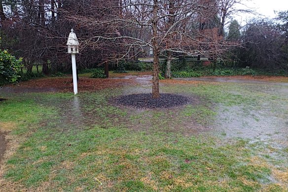
My husband and I are in Italy at the moment but are keeping a close eye on the weather back home in Burradoo in the NSW Southern Highlands. The pics [below] show our back yard has turned into ‘Lake Burradoo’. Our wonderful housesitter Bruce has been clearing the drains of debris. Meanwhile we are having a heat wave in Italy. I think I know where I’d rather be.

The lightly flooded ‘Lake Burradoo’ backyard, NSW Southern Highlands

The lightly flooded ‘Lake Burradoo’ backyard, NSW Southern Highlands

Grounded in Griffith overnight. Work disrupted, but more than happy to enjoy another great Italian meal.

Let’s just say when I was parked outside my friends house, the wind was THAT strong it started to shake my car and I actually thought I was going to tip over.

How many umbrellas do you think got bent and broken by the wind? 50,000? We should design an umbrella specifically for Sydney and this kind of ... thing.

Advertisement

30,000 without power across NSW

By Kayla Olaya

Tens of thousands of homes are currently without power as destructive winds and intense rain begin to bring down trees and powerlines, according to energy provider AusGrid.

Across NSW, 30,000 homes are without power. The hardest-hit areas currently are the Central Coast – which is experiencing evacuation warnings on multiple coastline homes – with 15,000 homes without power, then the Hunter Region with 13,000, and finally 1500 in Sydney.

Fallen trees and broken down power lines are the main cause of the widespread power outages. Meanwhile, AusGrid has deployed emergency crews to remove hazards and turn the power back on when it’s safe.

“Please watch out for hidden hazards around fallen or damaged trees. Never approach fallen power lines, always assume they are live and stay at least eight metres – or two car lengths – away from them,” said the energy provider.

South Coast and Illawarra forecast for rainy, gusty night

By Kayla Olaya

The NSW South Coast and Illawarra are bracing for a night full of heavy rain and destructive winds as the coastal low continues its path down the east coast of the state.

Senior Meteorologist Miriam Bradbury at the Bureau of Meteorology said the destructive weather will be focused on these areas, but that the severe weather warning continues in place throughout the state.

“The most intense impacts, including the heavy rainfall, are most likely across the Illawarra and parts of the South Coast. So really, that’s the key focus, but it’s definitely not out of the question across the rest of the warning areas too,” Bradbury said.

The rest of NSW’s east coast is still forecast to receive strong weather overnight.

What you need to know

By Kayla Olaya

Good evening, and welcome to The Sydney Morning Herald’s live coverage of today’s weather event, as a rapidly intensifying low-pressure system brings heavy rain and wild winds to Sydney and around the state.

Here’s what we know so far:

  • The BoM has issued a severe weather warning for much of the NSW coast, as the NSW SES says the complex low-pressure system is heading south into Newcastle, Sydney and the Illawarra, lashing the coast with wind and rain.
  • Most of coastal Sydney has been advised to stay indoors, as dangerous winds hit the city, including gusts in excess of 125km/h.
  • About 21,000 properties are without power in NSW as a result of today’s coastal low. Energy distributor Ausgrid said the worst-affected region was Central Coast, with 13,000 homes without power, 7000 in the Hunter Region, and an estimated 500 customers in coastal Sydney.
  • An estimated 1200 SES volunteers have responded to 1039 callouts throughout the state, with falling power lines, trees, and danger on roads likely to increase as the storm progresses.
  • The system began to impact metropolitan Sydney this afternoon, before it is expected to move to the South Coast and then into the Tasman Sea during the day tomorrow.
  • Sydney could see 50mm to 70mm of rainfall, with more than 100mm in isolated falls in coastal parts of the metropolitan area. The Warragamba Dam has hit 98 per cent capacity and will probably spill in the next few days, WaterNSW has said.
  • Heavy rainfall could lead to flash flooding anywhere from Newcastle to the Illawarra, including Sydney, but the bureau is forecasting the heaviest downpour to hit the South Coast.
  • NSW Emergency Services Minister Jihad Dib has said “the situation is going to worsen over the course of the next 24 hours”, before the impacts of the low-pressure system are likely to ease on Thursday.
  • SES deputy commissioner Debbie Platz has thanked the community for heeding weather warnings and bracing for extreme conditions, urging households to download the Hazards Near Me app to stay up to date.
  • The rapid intensification, or “bombogenesis”, of the low into a fierce weather system, dubbed a “bomb cyclone” by meteorologists, is a rare event most often seen during winter. You can read more about the science of the phenomenon here.
Advertisement

Train hits fallen tree in Sydney’s west

By Kayla Olaya

A train in Sydney’s west was hit by a tree after it fell from a neighbouring property, as strong winds continue to batter Sydney.

Emergency services were called to Kingswood at 5.45 pm after reports that a tree had fallen onto a train from the back of a childcare centre.

The train stopped to avoid being struck by the tree, and managed to be hit only at the front by a portion of the smaller branches.

The train did have passengers onboard who got off at Penrith station, and no one was injured.

Transport for NSW is investigating the incident and working to remove the train from the tracks.

Replacement buses are in place.

SES responds to more than 1000 callouts across NSW

NSW SES deputy commissioner Debbie Platz has thanked the community for heeding weather warnings and bracing for extreme conditions, saying it had helped take some of the load off volunteers, and save homes.

An estimated 1200 volunteers have responded to 1039 callouts throughout the state, with falling powerlines, trees, and danger on roads likely to increase as the storm progresses.

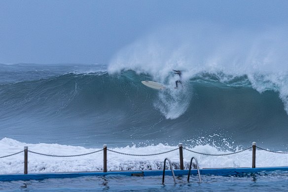
Surfers take to Dee Why Beach to make the most of the coastal low as it bears down the NSW coast.

Surfers take to Dee Why Beach to make the most of the coastal low as it bears down the NSW coast.Credit: Danielle Smith

“What we’re seeing already are trees and power lines coming down in some parts of the Central Coast and Sydney,” Platz told ABC News.

“We’re so grateful to the community that they heeded our warnings, and they have prepared their homes for this particular event because that will, no doubt, save some of their properties.”

South Coast residents told to stay inside amid widespread severe weather warnings

By Penry Buckley

Residents around Jervis Bay and Batemans Bay are being told to stay indoors, with a “watch and act” warning issued by the SES amid heavy rainfall and damaging and destructive winds.

It comes after updated severe weather warnings for residents across the Illawarra and the South Coast, with people in Sydney, the Central Coast and the Hunter Region also advised to continue to monitor conditions as damaging winds and heavy rainfall move southwards this evening.

The Bureau of Meteorology has advised that the complex low-pressure system which has caused havoc across NSW so far today is currently located offshore of the Hunter Coast, and gradually tracking southwards before an expected north-east turn into the Tasman Sea during Wednesday.

“Winds are expected to strengthen along the central to northern Great Dividing Range, southern ranges and ACT this evening,” it said.

Peak gusts in excess of 125 km/h are expected between Jervis Bay and Moruya, with this risk easing during Wednesday morning. Heavy rainfall may lead to flash flooding in the Illawarra south of about Wollongong later this evening, extending southwards towards Bega in the South Coast, with six-hourly totals between 50 to 80 millimetres likely, and isolated totals up to 120 millimetres.

Winds averaging 60 to 70 km/h, with peak gusts of around 110 km/h are possible along coastal parts from the South Coast to the Mid North Coast, including the Sydney metropolitan area. Severe weather warnings extend from as far as the Queensland border to Tathra on the Sapphire Coast.

Advertisement

Some disruptions to rail network as CBD quiet at peak hour

By Sally Rawsthorne and Kayla Olaya

In Sydney’s CBD, commuters appear to have heeded warnings to leave early or work from home, although disruptions have affected other parts of the rail network.

At 5pm, the crowds that normally gather at one of the main bus hubs, Wynyard, were nowhere to be seen. Half-empty buses were leaving the station and there were no lines.

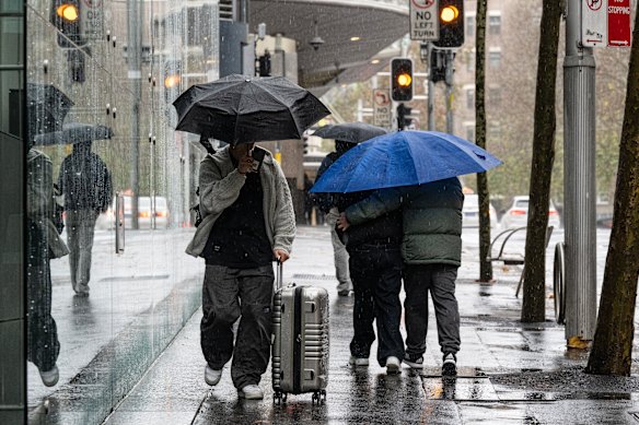
Pedestrians brave the wet and windy weather on Goulburn Street in the Sydney CBD.

Pedestrians brave the wet and windy weather on Goulburn Street in the Sydney CBD.Credit: Louise Kennerley

Speaking to Nine News earlier, Transport for NSW co-ordinator-general Howard Collins said travel was suspended between Wyong and Fassifern on the Central Coast & Newcastle (CCN) Line, after a tree fell on power lines above the train at Dora Creek.

Earlier, crews removed a tree from the tracks between Dapto and Kiama again, reopening a section of the South Coast Line.

Most Viewed in National

Loading

Original URL: https://www.brisbanetimes.com.au/national/nsw/sydney-weather-live-bombogenesis-triggers-severe-weather-warning-as-rain-sets-in-20250701-p5mbib.html