Bureau of Meteorology forecasts half of Australia will be hit with above median spring rain
Cooler temperatures and wet weather are on the cards for spring, with winter set to make a dramatic exit and storms to hit four states.
Environment
Don't miss out on the headlines from Environment. Followed categories will be added to My News.
The Bureau of Meteorology has warned that half of Australia will very likely be in for a cold and wet spring.
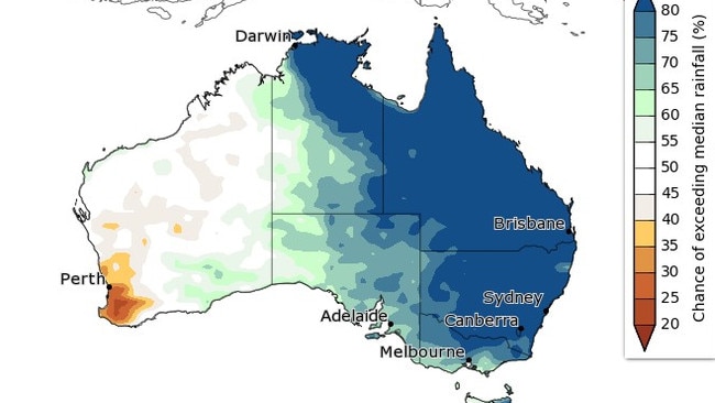
According to an official outlook issued on Thursday, there’s an 80 per cent chance that almost half of Australia will be lashed with above median levels of rainfall from September to November. In a graph shared by the Bureau, large swathes of the country are forecast to be effected, from the tip of Darwin to almost all of NSW.
Stream more weather news live & on demand with Flash. 25+ news channels in 1 place. New to Flash? Try 1 month free. Offer ends 31 October, 2022 >
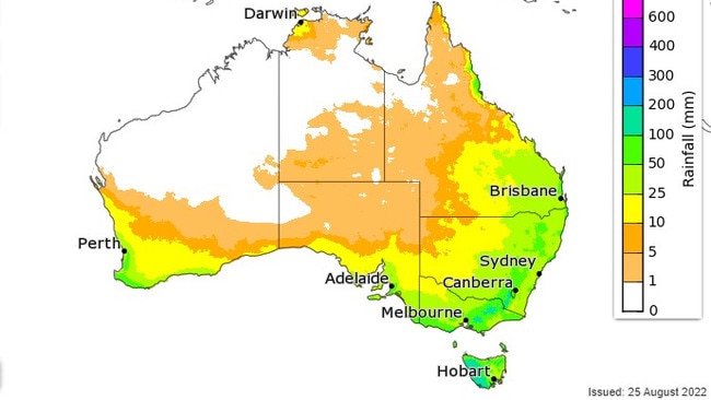
In September, rainfall totals between 25mm to 50mm are expected in Sydney and Brisbane, while patches of NSW could record up to 100mm. Victoria appears to be in for a wetter spring, with 50mm to 100mm expected.
Some patches could even receive up to 200mm of rainfall.
However, a largely dry September to November is expected for Western Australia. This is especially true for residents in the southwest, where below median rainfall is expected. The majority of the state will likely receive no rain in September, however forecasted totals will increase close to the state’s southwest coast.
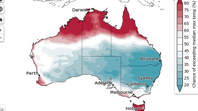
Temperatures also appear unlikely to hit the median maximums recorded in previous years. Bar patches of northern WA, the Northern Territory, Tasmania and Far North Queensland, the rest of Australia has under a 50 per cent chance of exceeding the median max spring temperature.
The BOM said that the majority of the northeastern half of the Northern Territory, as well as Queensland, NSW, northern and eastern Victoria, and parts of eastern Tasmania “have more than double the average chance of unusually high” rainfall between September to November. They said this will account for the wettest 20 per cent of spring records from 1981 to 2018.
“There is a high chance (greater than 80 per cent) of above median September to November rainfall for much of the eastern half of the mainland, with chances reducing gradually across Victoria, South Australia, and the Northern Territory; below median rainfall is likely for much of western Tasmania and southwest Western Australia,” the recent climate outlook report read.
The Bureau also clarified that past accuracy for their climate outlooks have been “moderate to very high”, except in parts of WA’s inland southwest areas.
Winter ends with ‘multi-storm’ outbreak
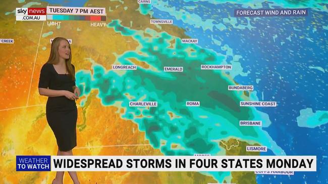
After a calm weekend, a widespread storm is set to hit four states from Monday, said Sky News Meteorologist, Alison Osborne.
A rainband emerging at 7am on Monday in the Northern Territory will push into Queensland’s east on Tuesday.
“These storms may be quite squally with the risk of some isolated heavy falls, typically through the state’s central-west,” said Ms Osborne.
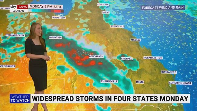
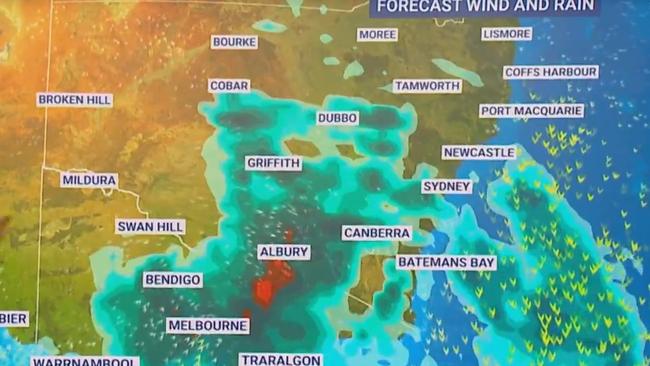
Another rain band will hit inland NSW and Victoria on Monday night, with a “dramatic cool change” forecast for Tuesday morning. Although the temperature drop will see the rains dissipate, Ms Osborne warns it could leave multiple rivers inundated with rain.
“While that band of showers and storms extends through inland NSW, they come together over Victoria, with heavy rainfall, the further risk of flash flooding and river rises and then quite a dramatic cool change which will flush most of the rain out,” said Ms Osborne.
“Heaviest falls are expected to be over Far North Queensland.”
Clash of the climate drivers
Adding to the high likelihood of a wet spring is the occurrence of a combined La Niña and negative Indian Ocean Dipole (IOD).
The possibility for a triple consecutive La Niña weather event has been increased to around 70 per cent, with the BOM declaring a ‘La Niña Alert’ on their ENSO Outlook. The climate driver increases the chance for above-average rainfall over northern and eastern Australia during spring and summer.
La Niña refers to changes in sea surface temperatures in the tropical Pacific Ocean, in which the eastern Pacific is cooler than normal, and waters in the western tropical Pacific is warmer than normal.
A negative IOD is also expected to continue into November, before returning back to neutral levels in January. The weather event is associated with above average rainfall from winter to spring.
If a La Niña is confirmed this year, it will be the second consecutive year in which La Niña and a negative IOD has collided.
Previously, the two climate drivers also combined in 2010, which also saw South East Queensland hit with record flooding.
Originally published as Bureau of Meteorology forecasts half of Australia will be hit with above median spring rain


