
Torrential rain lashes the state, sparking rescues from flooded freeway
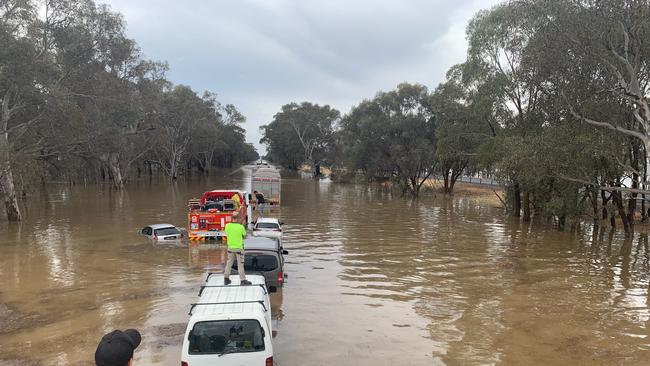
Scores of people have been rescued from cars and trucks stranded in floodwaters on the Hume Freeway as storms and torrential rain continue to drench Victoria. And more is on the way. Latest details.

News
Don't miss out on the headlines from News. Followed categories will be added to My News.
Scores of drivers have been rescued from their cars and trucks in northeast Victoria after storms and torrential rain smashed the state, with more on the way.
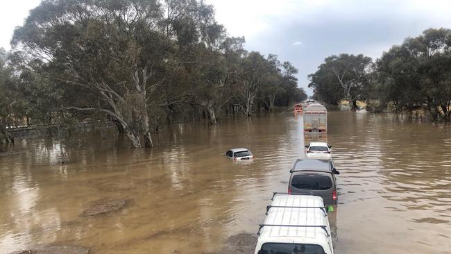
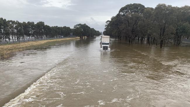
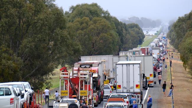
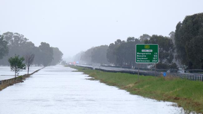
Hundreds of vehicles became trapped on the Hume Freeway north of Wangaratta amid calls from emergency authorities to stay off the roads with about a month’s worth of rain falling in one day.
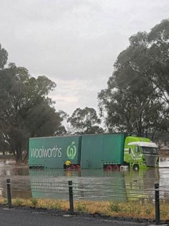
Taylor McPhail told the Herald Sun he and his co-workers were forced to climb onto the roof of their furniture company van when they became trapped on the freeway, about 275km northeast of Melbourne.
LAWYER X: HOW WE UNCOVERED THE TRUTH
D-DAY FOR A-LEAGUE EXPANSION IN MELBOURNE
VicSES volunteers have responded to more than 20 requests for assistance requiring rescue from flood water, including a number of vehicles impacted by flood water on the Hume Highway. Flash flooding can occur quickly - never walk, ride or drive through floodwater. #vicstorms pic.twitter.com/kMQAhmiwtt
— VICSES News (@vicsesnews) December 13, 2018
“We had to get onto the roof of the truck, just opened the door and climbed up,” the 28-year-old said.
“It was too deep. It was probably getting close to about 1m deep.
“If it rose more we probably would have floated.”
Mr McPhail said there were about 250 stranded cars along a 3-4km stretch of the freeway, the main road link between Melbourne and Sydney, just north of Wangaratta.
“A couple of smaller cars like hatchbacks floated away,” he said, after being winched to safety.
“I think the truck’s wrecked too. It’s got water through the cab. It was high enough to get into the cab.”
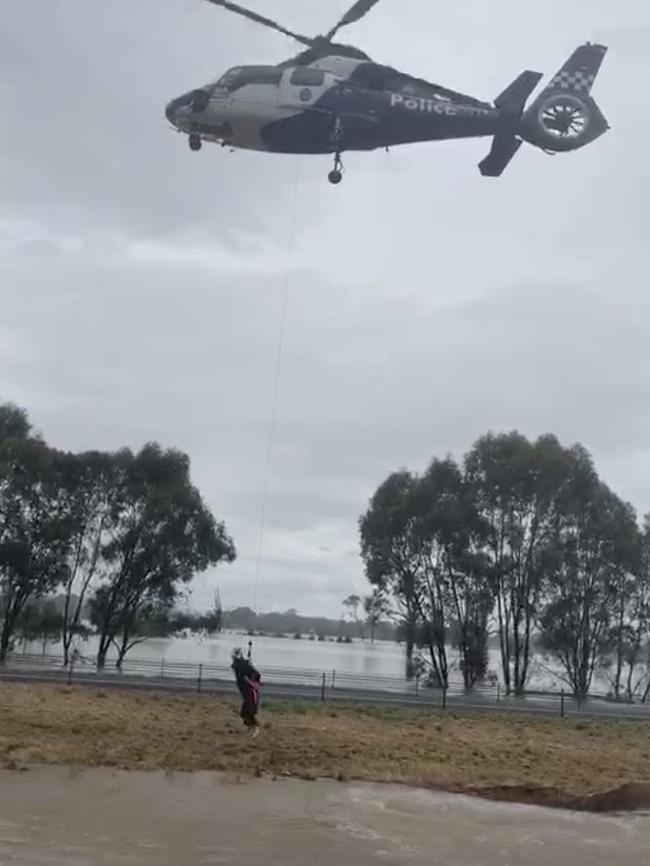
Keep calm and get winched. Hume Highway flooded just south of Wangaratta. pic.twitter.com/HvIesavPIc
— Hugh Nailon (@HughNailon) December 13, 2018
Flash flooding can occur quickly due to heavy rainfall. Never walk, ride or drive through flood water. It can take only 15 centimetres of water to lose control of your vehicle and float. (2/2) pic.twitter.com/fkXBCBaTcc
— Victoria Police (@VictoriaPolice) December 13, 2018
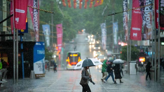
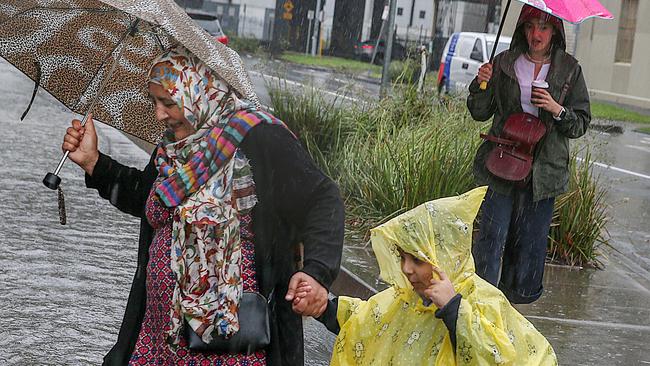
Melbourne has also been smashed by heavy rain today, with more than 32mm recorded in the CBD, 35.4mm at the airport and 47.8mm in Sandringham.
Keilor recorded 43mm between midnight and about midday, Sunbury 39mm and Altona 38mm.
The city’s average rainfall for the entire month of December is 59mm.
But northeast Victoria copped the worst of the weather, with nearly 70mm falling at Wangaratta and more than 160mm at nearby Everton by the afternoon.
And the Bureau of Meteorology is warning of more rain and possible hail for the region.
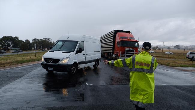
The SES says 16 drivers have been rescued on the Hume Freeway, which is closed in both directions between North Wangaratta and Barnawartha North.
Federation Way is also closed from just north of Wangaratta until near Rutherglen, and
the Great Alpine Rd from Buckland Gap Rd to Tarrawingee.
“Really challenging conditions out there. We’re just sort of at the mercy of mother nature at the moment,” VicTraffic spokesman Chris Miller said.
DO YOU HAVE PICTURES? EMAIL NEWS@HERALDSUN.COM.AU
One driver, Dave Lloyd, said he battled “insane” rain and flood waters on the way from Melbourne to Wodonga.
“The rain was insane, we actually joked to our boss that he might have to book us a motel for the night,” Mr Lloyd said.
“The Sydney-bound road was flooded and there must’ve been 200 plus vehicles stuck.”
Bureau of Meteorology senior meteorologist Rod Dickson said more than 100mm had been recorded before 9am around the Wangaratta and Myrtleford areas.
In Melbourne, the west saw more rainfall than the east, with up to 30mm in some places.
Potentially damaging winds and some hail was possible for later in the day, particularly for the east of the state.
Another 20-50mm is forecast for south of the state on Friday, and possibly more than 100mm over the Gippsland Coast and Otway Ranges.
“This low pressure system that’s developing across Victoria’s being fed by very moist air coming down from the tropics and as we see the rain develop and thunderstorms, they’re really feeding on that moisture,” Mr Dickson said.
“The risk is pretty much statewide with the heavy rain today.”
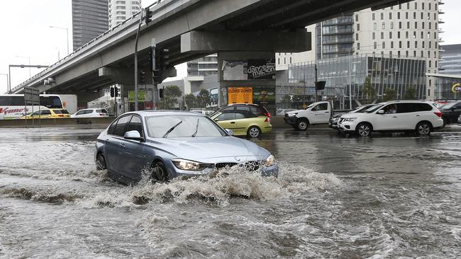
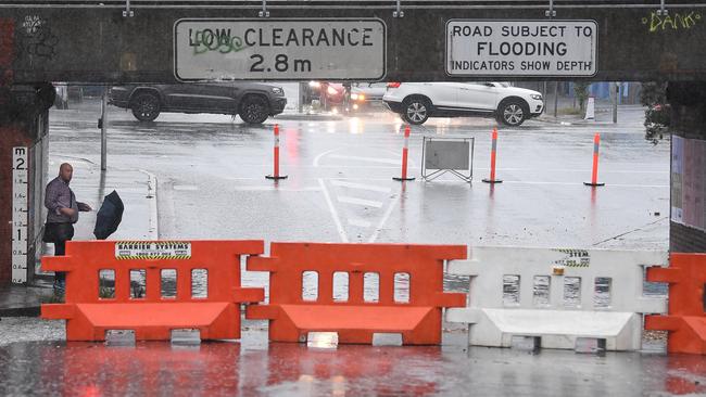
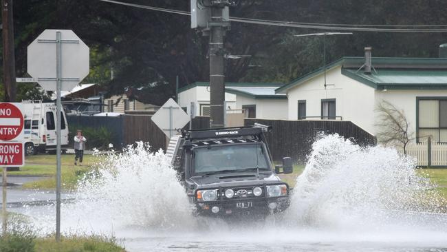
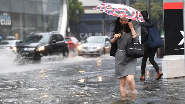
Montague St under the Westgate has been hit with flash flooding, with a serious crash closing the Nepean Highway at Mount Martha and urging further calls for motorists to drive to the conditions.
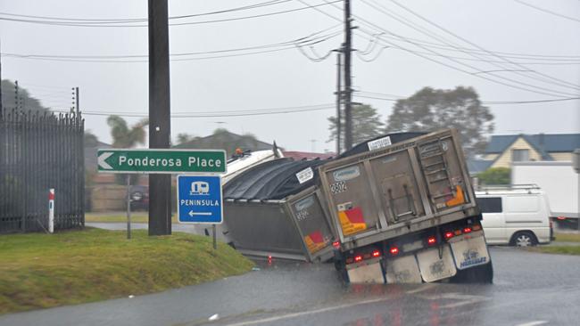
On the Peninsula, a truck became stuck on a collapsed corner of road in Dromana.
Two left hand lanes were closed on the Ring Road near Plenty Rd due to flooding, with the speed reduced to 60kmh in the area.
Flooding was also reported at Victoria St in Footscray; Maribyrnong Rd in Maribyrnong; and outbound traffic on the Westgate near Williamstown Rd.
The Beechworth Bakery in Beechworth has suffered damage from the deluge, but the main room in the popular bakehouse is still running.
“A lot of the water is coming in from the roof,” employee Cody said.
The mops are out at Beechworth bakery â˜”ï¸ rain has flooded part of the dining room @WINNews_Alb pic.twitter.com/uoErg3Ecd3
— Alice Pohlner (@alicepohlner) December 12, 2018
The rain has well and truly arrived in #Melbourne. Between 6am and 7am Coldstream recorded 18mm, Keilor 12mm and both Laverton and Altona 11mm. Expect this to continue and deteriorate throughout the morning. Keep an eye on the latest warnings https://t.co/zalVqkM8eX pic.twitter.com/xHynHqDpiI
— Bureau of Meteorology, Victoria (@BOM_Vic) December 12, 2018
Across the state, the SES has received more than 370 calls for help so far, mostly from people affected by flooding.
A huge tree fell onto the road near Flagstaff Station this morning, delaying traffic in the area.
Keilor in northwest Melbourne received about 14mm within the space of about half an hour early on Thursday, Bureau of Meteorology senior forecaster Dean Stewart said.
Coldstream northeast of the city copped more than 20mm within an hour.
The torrential rain is linked to Cyclone Owen, which has smashed northern Australia.
“This low pressure system that’s developing across Victoria’s being fed by very moist air coming down from the tropics and as we see the rain develop and thunderstorms, they’re really feeding on that moisture,’ Mr Dickson said.
Moderate to locally heavy rain expected across parts of Victoria over the next few days with THURSDAY the focus. Check https://t.co/HLs2UYFQyQ for the latest #VicWeather warnings. @vicsesnews @vicemergency #VicStorms #melbweather pic.twitter.com/7woQLOnEPM
— Bureau of Meteorology, Victoria (@BOM_Vic) December 12, 2018
A flood warning remains in place for greater Melbourne, West and South Gippsland, and parts of northern and southwest Victoria.
Most of the state is also covered by a severe weather warning, and there’s a road weather warning for all Melbourne suburbs.
“Many places will have a decent chance of seeing their wettest day this year,” forecaster James Taylor earlier said.
Thunderstorms have produced raised dust across the #Mildura area and 13mm in 10 minutes at Walpeup. https://t.co/fJqsG1mOyE pic.twitter.com/If4KVqqrOT
— Bureau of Meteorology, Victoria (@BOM_Vic) December 12, 2018

âš¡ Here's #Victoria's thunderstorm forecast for tomorrow with damaging winds likely for any storms that develop. Stay on top of our warnings here: https://t.co/3zAZ2G2HRq pic.twitter.com/z46RiXERGR
— Bureau of Meteorology, Victoria (@BOM_Vic) December 11, 2018
Tropical Cyclone Owen is moving slowly west over the southern Gulf of Carpentaria and is forecast to strengthen. #CycloneOwen https://t.co/AWJKLhPYLV pic.twitter.com/qJwEkGCVDB
— Bureau of Meteorology, Northern Territory (@BOM_NT) December 11, 2018
While the worst of the weather is over for Melbourne, tomorrow is still expected to be a wet one with up to 20mm expected in the city.

Subscribe now: What’s included when you sign up to The Advertiser
A subscription to The Advertiser gives you much more than just unrestricted access to SA’s best news coverage. Find out more here.

What footy fans get from Advertiser subscription
Love everything AFL? Here’s what footy fans get as subscribers to The Advertiser – including the best SuperCoach advice from The Phantom, extra stats and live scores.