Adelaide weather: Severe weather warning as damaging winds up to 100km/h sweep SA
South Australians have been warned to brace for wild winds and icy weather extending into the night.

Weather
Don't miss out on the headlines from Weather. Followed categories will be added to My News.
New wild weather warnings have been issued for major centres across the state as Friday's latest band of wild wind and rained crashed into Adelaide in the evening.
On Friday evening, damaging wind warnings remained in place for the Adelaide Metropolitan area, Mount Lofty Ranges, Lower Eyre Peninsula, Kangaroo Island, Lower South East and parts of West Coast, Yorke Peninsula, Mid North, Murraylands and Upper South East districts.
Winds of 60 to 70km/h with gusts reaching 100 were predicted for the state's west coast while damaging winds around the Mount Lofty Ranges were expected to continue overnight.
A gust of 115 km/h was recorded at Neptune Island at 12:55 pm.
The winds were set to develop on Friday morning to bring “a vigorous southwesterly flow” which will persist through to Saturday morning, according to the BOM.
Those in the Mount Lofty Ranges were told to expect strong winds averaging 50 to 60 km/h and damaging gusts to reach around 90 km/h from early Friday morning.
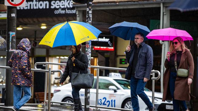
Adelaide had recorded 6.4mm of rain on West Terrace by 5pm, according to the Bureau of Meteorology, with a top temperature of just 11.8C.
At Mount Lofty, 14.2mm of rain was recorded with a high of just 6.1C, a low of 4.9C and a freezing apparent temperature of -1.2.
For parts of the coastline, winds were expected to be about 100 km/h from Friday afternoon.
The wild winds were tipped to begin around the coastal fringe of the West Coast and extend east throughout the remainder of the day, likely impacting metropolitan Adelaide from the evening.
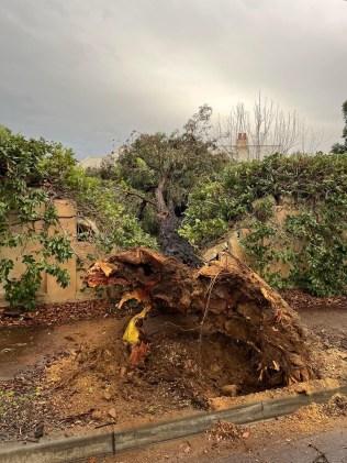
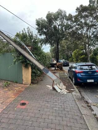
Winds had already started to cause damage on Friday evening, with a tree and Stobie pole brought down at Aroha Tce at Black Forest.


SES at a heightened level
SES has responded to around 84 incidents from 5:30am to 6:30pm.
A spokesperson said "SES is in a heightened level of preparedness with strong winds forecast over the next several hours."
Damaging winds are sweeping across South Australia, as weather conditions intensify on Friday, leaving many residents without power.
The full force of the strong winds brought down a large tree, firmly planted with deep roots in the Black Forest, right next to a powerline that was also uprooted right beside the tree.
The SES encourages people to contact 132500 if they are in need of assistance.
BOM weather update
A BOM spokeswoman told morning radio a “pretty wide area” would be affected.
She said Kangaroo Island had already experienced a wind gust of 85km/h.
“But not just winds, we’re talking some pretty serious rains to come through as well … and likely to hit the city from about 10am,” she said.
The State Emergency Services advise people should take precaution against the gusts.
This includes moving vehicles under cover and away from trees, securing loose items around your property, and staying indoors while conditions are severe.
âš ï¸ Severe Weather Warning for damaging #winds now includes #Adelaide and the south east coast. See https://t.co/VrNezW7MBG for details and updates; follow advice from @SA_SES. #SevereWeatherpic.twitter.com/jdXRFmuABc
— Bureau of Meteorology, South Australia (@BOM_SA) July 18, 2024
Due to the severity of the winds, the state government has issued a Code Blue for rough sleepers – urging those across the Adelaide metro area, Fleurieu Peninsula, Kangaroo Island, Upper Spencer Gulf, Lower Eyre Peninsula and the Copper Coast to seek shelter.
To support rough sleepers the Baptist Care’s Westcare Centre will be open overnight from 1pm today until 8am.
Similarly, Toward Home Resolve Team have sent out seven units to known sites where homeless people camp or sleep rough to provide help.
Earlier Code Blue activations remain in place for the Clare Valley, Limestone Coast and Riverland until 25 July.
Rare weather occurrence
This comes after The Advertiser warned about a “rare” weather event growing above Antarctica which would bring in more cold fronts and rainfall to Australia’s south in the coming weeks.
The sudden stratospheric warming event is caused by an “abrupt increase in air temperature high above the Earth’s polar regions” in the stratosphere layer, which is about 20-40km above the Earth’s surface.
The warming event could filter down through the atmosphere and ultimately allow chilly polar air to drift further away from Antarctica and closer to the mid-latitudes.
This would cause southern Australia to experience more cold fronts, stronger winds and low pressure systems, and increased rainfall and snow potential could occur in Australia’s southwest and southeast.
Adelaide Weekend Forecast
Adelaide will see a top of 14C with north to northwesterly winds climbing to 30 to 45 km/h on Friday morning before turning westerly in the evening, with heavy rainfall likely to hit late morning.
On Saturday, temperatures will climb to 15C with morning winds of 35 to 50 km/h eventually easing to 25 to 35 km/h. There is a high chance of showers.


