
Adelaide tipped to miss out on tropical downpour but deluge and severe fire danger elsewhere
A spectacular tropical deluge is tipped to hit some parts of South Australia this weekend, yet bizarrely, severe fire danger warnings are being issued in the lead-up.
SA News
Don't miss out on the headlines from SA News. Followed categories will be added to My News.
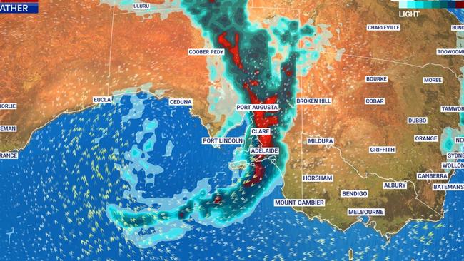
Adelaide is set to dodge this weekend’s tropical deluge, but other areas across the state will not be spared, with more than 100mm is expected to fall in parts of South Australia.
In the lead-up to the wet weather, fire danger warnings have been issued Thursday and Friday, with residents in the Lower Eyre Peninsula, Mt Lofty Ranges and Lower South East warned of severe danger.
There are total fire bans for those three regions on Thursday.
Fire danger remains high and very high in most parts of the state on Friday, excluding the West Coast.
While flood warnings remain in place for districts in the west and the north, Adelaide is only expecting up to 10mm on Sunday.
Senior forecaster from the Bureau of Meteorology, Vince Rowlands, said this was due to the low-pressure system slowing down in the west of the state on Wednesday.
“It is unlikely we will see the rainfall we were initially predicting in Adelaide,” he said.
“However, the forecasts are constantly changing and if there are thunderstorms, we could see some downpours across the city.”
Senior forecaster Jenny Horvat, said remnants of ex-tropical cyclone Tiffany, which has ravaged other states including Queensland, have brought the moisture and will peak on Saturday.
“It is a tricky situation for the end of the week but ahead of that we’ve got some warmth coming,” Ms Horvat said.
Adelaide is forecast to reach 35C on Thursday and Friday.
“We’ve got some moisture still hanging in the north of the state for today and it looks like that's going to feed into the Eyre Peninsula on Thursday,” she said.
Central parts of the state will see up to 100mm of rain, Ms Horvat said.
“It is highly variable with the nature of thunderstorms, it can mean someone can get quite a lot or not that much, so it's a broad range,” she said.
“There is the potential over southern parts of the pastoral districts and maybe parts of the west coast district that could be seeing that 100-plus millimetres … up until midnight Sunday.”
The wild weather could continue into early next week, Ms Horvat said.
Highest rainfall in the north of #SouthAustralia over the last 24 hours to 9am was 58mm at Mobella and 46.8mm at Ernabella/Pukatja. Highest 3 day totals are 71.8mm at Ernabella/Pukatja and 65.2mm at Mobella. See other rainfall at https://t.co/WpA4uLnX9A at sa/flood/. pic.twitter.com/XkH0Ham2yx
— Bureau of Meteorology, South Australia (@BOM_SA) January 17, 2022
“This is the time of the year for cyclones, often we don’t see the remnants of cyclones, but if we were to see them it would be this time of the year,” she said.
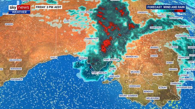
Sky News Weather meteorologist Rob Sharpe said records could be broken in SA.
“Exactly how much rain is hard to pick but quite a few models are forecasting totals above 100mm north of Adelaide with some pockets up to 150mm,” Mr Sharpe said on Tuesday
“That would be one of the bigger rain and flood events that we’ve seen in South Australia for quite some time and might be one of the heaviest rain events in about a decade for many areas.”
February 2011 was the last time rain at the same projected level fell in the state. It could lead to significant flooding.
Mr Sharpe said the unsettled conditions are likely to crank up from Friday with “multiple waves” of rain and storms over the state. But with several days to go until then, it is unclear which areas might be most affected.


‘The C word may have taken her body, but never broke her spirit’
Brave little India Hogg, 9, left hearts breaking as she farewelled her mum Amanda saying, “I’ll think of you every moment for the rest of my life.”
Read more

Tragic end for Adelaide’s troubled $22m Powerball tradie
He was only 22 when he won the lifechanging jackpot but that dream-come-true has come to a nightmare end five years later.
Read more