
South Australia’s winter forecast: Adelaide weather watcher Darren Ray has his say on big chill versus sunny days
Is it time to drag out the brolly and the thermals? The Advertiser’s weather watcher, Darren Ray, reveals his winter forecast.

SA News
Don't miss out on the headlines from SA News. Followed categories will be added to My News.
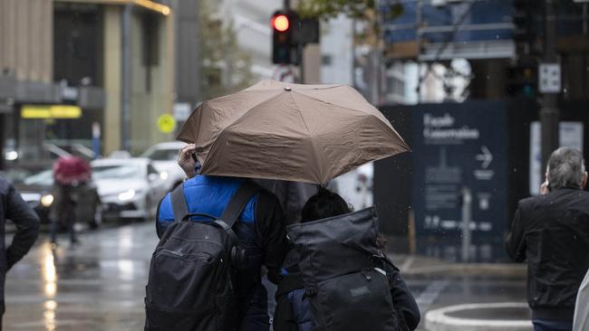
The heavens finally opened this week, with a wild storm bringing downpours of up to 40mm across some parts of the state.
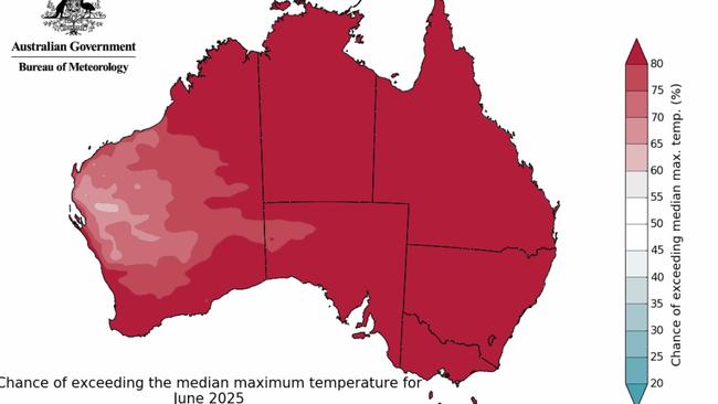
But it’s unlikely to answer farmers’ prayers for a rainy start to winter, with The Advertiser’s weather watcher, Darren Ray, predicting a drier, warmer and sunnier kick-off to the new season after a very dry autumn.
The respected meteorologist said weather charts showed the chance of patchy rain in coming weeks, with more significant falls possible from mid-June into early July.
“It’s likely to continue to be sunnier and warmer than usual with less rain than average,” said Mr Ray, who delivers seasonal forecasts for advertiser.com.au and The Advertiser.
“Essentially what I’m seeing is that winter will be warmer than average with temperatures probably in the high-teens rather than the mid-teens. With sunnier conditions I would expect less frost events overall, but with drier soils and occasional cold outbreaks there will still be some risk of occasional severe frost.
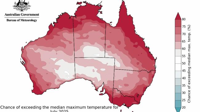
“More sunshine, less rain, though tending more average towards the end of winter, in August, with more average temperatures for late winter and spring.”
But Mr Ray said weather models indicated a shift to average to just above average winter and spring rainfall this year.

But he said changes in global climate meant he had less faith in that modelling than he used to and he was not certain its suggested rainfall would necessarily materialise.
He said a La Nina pattern – which dominated last spring and summer – was on track to resurge towards the end of this year. Its influence, combined with a negative Indian Ocean Diopole, would bring milder, wetter conditions for spring and the start of summer.
He said those weather patterns would mirror last year’s spring and early summer.
“What I’m seeing at the moment is it is going to be a lot like last year,” said Mr Ray, who spent nearly 18 years with the Bureau of Meteorology and now works as a climate specialist for the Department of Environment and Water.
“That pattern of La Nina and negative IOD normally kicks off more rainfall and milder conditions.”
Mr Ray – who predicted a dry, hot autumn this year – said it was now shaping up to be the hottest on record, with the whole month of March and the first half of May up to 4C warmer than average.
He said most of the South Australian agricultural districts were now in drought after a severely dry 2024 and year to date. In Adelaide, total rainfall for the year was still about 100mm behind the average for this time of year.

“If you look at the weather patterns at the moment, we’re seeing weather systems that have got a really strong ridge of high pressure and that’s one of the reasons we had such a warm autumn, with lots of clear skies, less cloud than usual, obviously less rainfall than usual,” he said.
“That pattern’s going to continue through most of winter, and then start weakening off. What we’re seeing is all very consistent with trends we’ve been seeing and what’s expected in climate change. It is definitely concerning but not totally unexpected.”


Adelaide Crow star’s sweet video reveals pregnancy
Adelaide's newest football family is expanding as Crows recruit Isaac Cumming and fiancee Mia Young reveal some baby news.

Why an Adelaide family with a thriving business could lose everything
For years they’ve run a thriving business in Adelaide. Now, as they wait for a government decision, this family fears they’ll lose everything they have worked for.