
Severe weather warning: Mini tornado cuts path of destruction through Adelaide's north
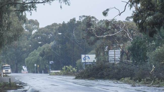
Roads and homes have been flooded and dozens of trees are down in Adelaide's north, after a brief tornado struck in the early hours and dumped up to 60mm of rain.
SA News
Don't miss out on the headlines from SA News. Followed categories will be added to My News.
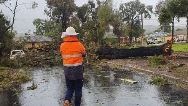
A tornado struck the northern suburbs in the early hours of Monday morning, bringing down powerlines, trees, and causing severe damage to homes.
The State Emergency Service (SES) said “a small, brief tornado” hit Salisbury and some surrounding suburbs.
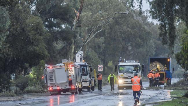
They responded to more than 200 jobs for weather damage, including flooded homes, damaged roofs and fallen trees and powerlines at about 5am.
Volunteers have so far responded to more than 150 jobs, however their efforts have been made difficult due to large amounts of debris blocking access to roads.
Nine unexpected power outages have also been reported across metropolitan and regional areas throughout the morning due to the downpour and fallen trees.
Over 1300 customers have been affected by an outage which ranges from Brahma Lodge to Para Hills West, restoration is not expected to be completed till 5:00pm Monday afternoon.
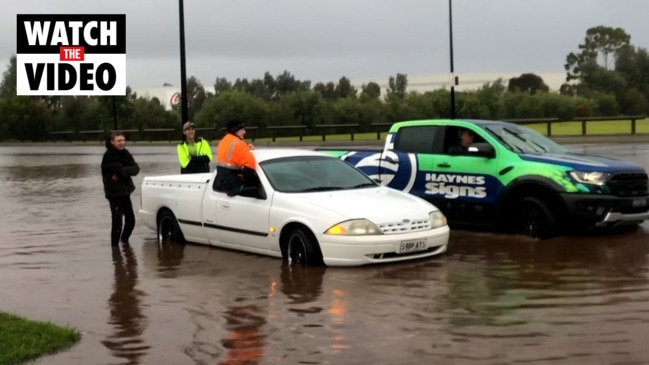
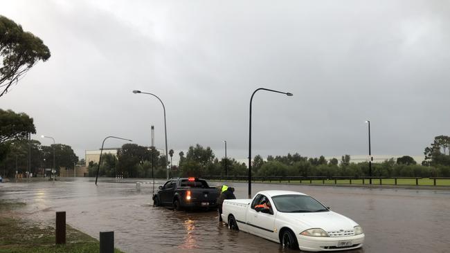
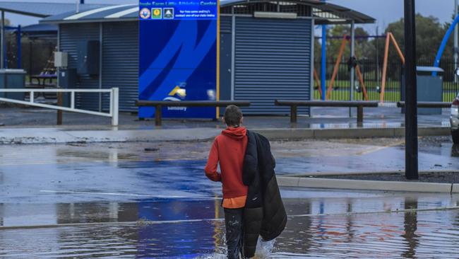
Cars were temporarily stranded in flooded roads in the north of Adelaide early this morning after parts of the area were lashed with more than 60mm of rain.
The northern suburbs were the worst hit, with major roads including sections of Main North Rd and Salisbury Hwy among those affected.
Sections of those roads were closed after some motorists tried to pass through floodwaters and became stuck.
SES state duty officer Brenton Clarke said a severe weather cell that passed through the northern suburbs triggered dozens of jobs.
“With this amount of jobs, it certainly puts pressure on our crews because they are generally jobs that take time,” he said.
“The call-outs range from water passing into homes through roofs, flooding and trees down.
“We are going to be pretty busy for a few hours.”
Mr Clarke said a combination of debris and flooding was impacting roads.
“We had some pretty strong winds when that weather cell passed through, so there are large branches and powerlines down across roads,” he said.
It comes after the rain arrived in Adelaide on Sunday and it hasn’t stopped with more than 32mm falling across the city overnight up to 9am on Monday.
The metropolitan area and the Adelaide Hills felt the brunt of the deep low pressure system, which continues to move east from Kangaroo Island.
At Parafield, more than 60mm of rain fell in the 24 hours up to 9am on Monday morning – with 15mm of that falling between 4am and 5am, while the Mount Lofty Ranges recorded 53.2mm and Adelaide received 35mm.
MAIN NORTH RD, SALISBURY EAST CLOSURE
— SA Infrastructure & Transport (@DFIT_SA) May 29, 2022
Main North Rd is closed to traffic between Smith Rd and Kings Rd, in both directions, due to flooding and trees down after a severe storm system came through the northern suburbs.
Please use an alternative route. https://t.co/bL612Ze13Ahttps://t.co/a4OfOguvaW
The Bureau of Meteorology is expecting more intense conditions on Monday with another severe weather warning issued for Adelaide Metropolitan, West Coast, Lower Eyre Peninsula, Eastern Eyre Peninsula, Yorke Peninsula, Flinders, Mid North, Riverland and parts of Mount Lofty Ranges, Murraylands, North West Pastoral and North East Pastoral districts.
It predicts damaging winds of 70km/h with gusts of up to 90km/h.
Conditions are expected to ease some time later on Monday.
The BOM said on Sunday evening that residents of southeast SA, Victoria, Tasmania and eastern NSW will feel the brunt of the weather systems with below-average temperatures, showers, low-level snow and brisk winds.
Severe weather warnings for damaging winds currently stretch from southeast Western Australia, across SA and include much of NSW and northeast Vic. The bureau said warnings are likely to continue over coming days.
Severe weather warnings will continue to evolve over the coming days, so people should continue to monitor warnings.
Coastal conditions will be particularly rough as the bureau said large waves and swell conditions will hit most of the southern mainland coast. Parts of the coast could see tides near or above High Astronomical Tide (HAT). Very large seas will accompany the front, largely in SA and western Victoria. People should monitor warnings and check conditions.
Flooding is continuing in several central inland and northern inland river systems from water flowing downstream from Queensland.
SEND IN YOUR WEATHER PHOTOS OR VIDEOS
If you have wild weather pictures or videos, send them in to The Advertiser – email advertiserpics@news.com.au
The BOM said given the length of time since the last wind event, there may be some damage to property and weakened trees, and flash flooding due to blocked drains.
That warning was echoed by the State Emergency Service.
The SES is on high alert throughout South Australia and state duty officer Robert Charlton urged people to prepare for the wild weather.
“Preparation remains the best strategy for people wanting to reduce the impact of severe weather to themselves and their properties,” he said.
“Something as simple as spending a little time ensuring your gutters and downpipes are cleaned and clear of clutter can help ensure people don’t have to deal with water running down the inside walls of their homes.”
He said SES crews will be ready to assist where required.
“The SASES will always be available to help the community in times of need, but prevention is much better than cure,” he said.
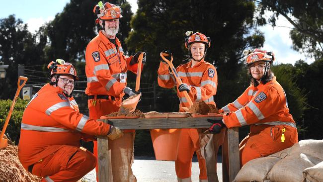
The volunteer service issued free sandbags to the public at various locations across the state on Friday and Saturday.
Join the conversation

Woman fighting for life after stabbing
A woman is fighting for life after allegedly being stabbed by a person known to her, with police and emergency services currently at the scene.
Read more

Watch: Heated court scenes as tobacco accused light up at detectives
Three brothers charged in the state’s anti-tobacco trade operation have left court and collided with the detectives who arrested them last year. See the interaction. Video: 7NEWS.
Read more