
Rain across Adelaide but winds pick up as Cherry Gardens fire continues to burn
Rain has fallen across Adelaide and the Hills, making it the wettest day since June 2019. Further to the north, there are flood warnings.
SA News
Don't miss out on the headlines from SA News. Followed categories will be added to My News.
Adelaide has had its wettest day in about 18 months.
The Bureau of Meteorology’s West Terrace station recorded 29.6mm in less than four hours on Monday.
Large areas of the state are on flood alert overnight with rainfalls of up to 80mm possible in some parts.
The Bureau has issued a warning for parts of the North West Pastoral, North East Pastoral, Flinders Ranges, Mid North, Riverland and Eastern Eyre Peninsula districts.
“A trough of low pressure located near Adelaide is moving in a north-easterly direction over central and northern parts of South Australia and will cross the SA eastern border early Tuesday,’’ a spokeswoman said.
“Cumulative rainfall totals, until midnight Tuesday, of 20 to 40mm, are possible with local heavy falls of 40 to 80mm over the south of the North East Pastoral District, the Flinders Ranges, southeast of the North West Pastoral District, Riverland, Eastern Eyre Peninsula and northern parts of Mid North.
“Rainfall may cause ponding and overland flow, together with rises in local creeks and riverbank flooding. Roads may be impacted.”
By late afternoon on Monday regional SA had already recorded substantial falls since 9am, the highest at Cape Willoughby of 15mm, Kingscote 12mm, Kadina 11.6mm, Neptune Island 11.2mm, Whyalla 8.4mm and Clare 8mm.
Catchments likely to be flood affected include: Flinders Ranges Rivers and Creeks, Broughton River, Lake Frome, Danggali Rivers and Creeks, North West Lake Torrens, River Murray Riverlands and Eastern Eyre Peninsula.
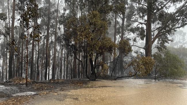
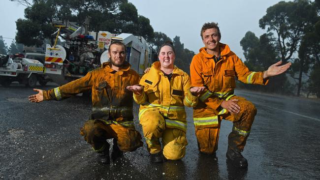
Hills residents and firefighters were relieved on Monday as heavy rain arrived, though it also hampered fire control measures in some areas.
“It’ll probably take all of the morning to moisten up the lower levels of the atmosphere,” Bureau of Meteorology senior forecaster Mark Anolak said earlier on Monday.
“From about midday onwards will be our best chance of picking up some good rainfall.”
The bureau expects falls of 5mm to 15mm, enough to put a dampener on the Cherry Gardens fire.
Rain is likely to fall through the afternoon before easing off early in the evening.
Lightning is expected but it will be accompanied by the rain, decreasing the risk of starting more fires. However, blustery winds have also picked up and are helping to fan the fire, causing breakouts to the north and east.
Overnight, winds remained light but temperatures remained stubbornly hot in the high 20Cs. The lowest temperature was reached at 5am on Monday when the temperature in Adelaide dropped to 25.6C.
Surface winds were swinging to the southeast – pushing the fire in a northwesterly direction.
However, the undulating topography with gullies made precise forecasting at a local level complex.
The bureau said rain fell heavily in the Far North, including 27mm at Oodnadatta. Flood warnings were active for Monday including the Flinders Ranges and eastern Eyre Peninsula.
On Sunday, Adelaide reached 42.7C, Port Augusta 45.3C and Mount Gambier 40.5C.


Wild scenes as man shot dead in Adelaide’s north
A neighbour has revealed the frantic scenes on a suburban street after a Taperoo man was shot dead late on Saturday night.

So long, Sugar Man: Huge queues for beloved shop’s last day
Hundreds of fans of the popular CBD patisserie were willing to wait for one final taste of their signature pastry treats. See the video.