
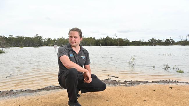
Levees built to protect Renmark during the 1956 flood have fallen into disrepair, prompting concerns that the town could be at risk
Concerns have been raised a Riverland town is at risk of copping the deluge of Victorian flood water due to ‘substandard’ levees urgently needing repair.
SA News
Don't miss out on the headlines from SA News. Followed categories will be added to My News.
Flood levees built to protect Renmark during the 1956 flood have fallen into disrepair in places, prompting concerns that the town could be at risk as the deluge in Victoria makes it way down the River Murray.
Deputy Premier Susan Close said some of the levees not controlled by the state government were substandard and she would work with councils and private landowners to fortify the structures.
Ms Close said she had confidence in the levees on Crown Land along the Murray, which would help protect the town of around 5000 people from floods which some have predicted could be the worst in almost 50 years.
The Murray is already at its highest level since 2016, with official predictions the flow over the border into SA would reach 90GL mid-November. Updated predictions will be issued later this week, which are expected to see the flow upgraded to as much as 120GL a day.
“However, many other levees are managed by councils and private landholders and we have less confidence in the integrity of these structures due to a lack of ongoing maintenance,’’ Dr Close said.
“We have a limited time to respond to the increased flows heading our way and I would like to see everyone working together to minimise the risk of inundation,’’ she said.
Local Riverland MP Tim Whetstone said it was a state government problem and urged Dr Close to move quickly to fix the problem, which he estimated would cost around $3.4 million.
“I just want to see some action, playing the blame game isn’t going to help,’’ Mr Whetstone said.
“If a wave does come down the river we won’t have to be sitting on the edge of our seat, biting our nails and thinking ‘what the hell is going to happen?’
“If we do the preparatory work, it puts us in good stead, no matter the flow is.’’
According to state government figures, 4.6km levees are on private property, 6.5km are on council freehold or road reserve, and only 1km on Crown land and roads.
One breach of the levee seen by The Advertiser in Renmark was several metres wide where a dirt road had been created through the bank. Opposite the break in the levee where three houses.
One resident, who did not wish to be named, said someone had brought in machinery to tear down the levee 12 months ago.
“The river is rising and we don’t want another flood like ’56,’’ she said.
Renmark Paringa Council chief executive Tony Siviour said he was seeking funding from the state government for levee repair. Mr Siviour said the council had also applied for funding from the National Disaster Resilience Fund.
“At 100GL it is relatively marginal (in regard to flooding) but it is better to be prepared for a higher-flow scenario,’’ he said.
Big 4 Loxton Riverfront Holiday Park manager Sam Obst said customers had already cancelled bookings, although most of the site was higher than the flooding in 1974.
Mr Obst said these cancellations would damage the local Loxton economy as for every dollar spent in caravan park bookings translated to a $23 contribution in the wider area.
“Loxton has probably lost $100,000 through yesterday’s cancellations,’’ he said.


Police hunting wanted man in connection to Blackwood arson attacks
Police are calling on the public to help find an allegedly armed man wanted after two Blackwood arson attacks.

Mali’s flatpack solution to tackle housing crisis
In an attempt to solve the state’s housing crisis and deliver more homes faster, Premier Peter Malinauskas has unveiled a new Ikea like plan.