
Severe thunderstorms threaten SA as cold snap set to kick-off November
The bureau has removed destructive winds from weather warnings for SA, but some areas are still in line for thunderstorms as a wintry chill sweeps the state.


SA News
Don't miss out on the headlines from SA News. Followed categories will be added to My News.
This article is unlocked and free to read in the interest of community health and safety. Get full digital access to trusted news from The Advertiser and Messenger with our great introductory offer.
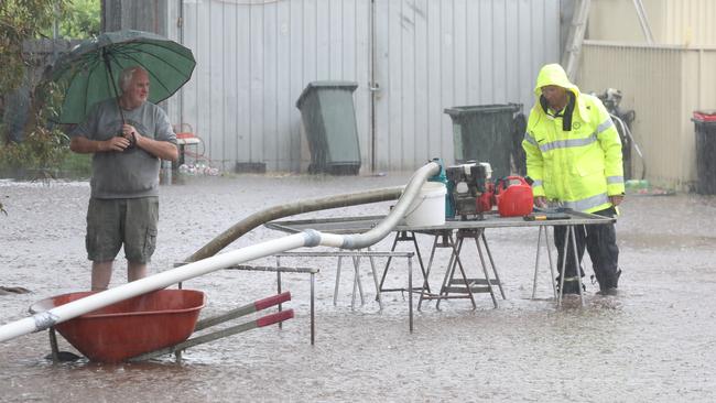
Large sections of SA have been warned to prepare for thunderstorms, with possible large hailstones.
The Bureau of Meteorology has warned the storms are possible for people in Mid North, Riverland and parts of Flinders, Murraylands, North West Pastoral and North East Pastoral districts.
However, destructive winds have been removed from weather warning.
âš ï¸ Destructive winds have now been removed from the Severe Thunderstorm Warning, with storms now past peak strength. Details at: https://t.co/u8FLHdKzkbpic.twitter.com/SpSLjaCde9
— Bureau of Meteorology, South Australia (@BOM_SA) October 30, 2022
Damaging winds of more than 100km/h have been recorded across SA on Sunday ahead of a cold snap to start the last month of spring.
A low-pressure system is moving across from the west of the state bringing with it intense winds and thunderstorms.
Oodnadatta recorded a 139km/h gust just after 3pm, while other areas in the west and north consistently recorded winds of around 90-100km/h.
Wind gusts more than 120km/h have been recorded on the Yorke Peninsula.
It prompted the State Emergency Service to issue a severe weather watch-and-act for people in the Eastern Eyre Peninsula and parts of West Coast.
Bureau of Meteorology spokeswoman Tina Donaldson said the wet and windy weather would continue across the metro area into Monday morning.
The wild weather comes ahead of a wet and cold start to the week.
Temperatures will drop to 15C on Monday in Adelaide ahead of 14C on Tuesday.
The city can also expect plenty of rainfall with up to 20mm forecast on Monday and Tuesday before the front begins to ease.
“In the wake of that low pressure system and front moving through, we will see some more rain and cooler conditions throughout the week,” Ms Donaldson said.
She said the reprieve isn’t likely to come until sometime Wednesday ahead of dryer conditions on the weekend.
“We’re looking at temperatures in the 20s next weekend in Adelaide, so that’s something for people to look forward too.”
A flood advice message was issued on Friday for River Murray residents between the South Australia/Victoria border and Lock 1.
The flow into the River Murray at the border is currently at 85GL per day and is expected to reach 100GL per day by early November.
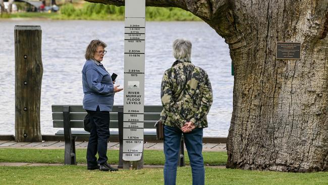
Flows into South Australia have not been this high since 2016.
As this higher flow moves into the warning area over the next two weeks, it will raise the River Murray to Minor Flood level.
It comes as new satellite images show the Riverland’s lakes and backwaters are already filled to the brim.
The SASES is still distributing free sandbags throughout the region, with pick-up locations in Berri, Loxton, Murray Bridge, Renmark and Waikerie.


Elderly woman rushed to hospital after shocking truck and car collision
A woman believed to be in her 70s has been rushed to hospital after a serious crash involving a truck and car in Adelaide’s inner northeastern suburbs.

‘Hospitality dying’: Regional business can’t make it in the city
A husband and wife team share their frustration with ‘impossible’ rent, wages and overhead costs after trying to bring their popular Ardrossan cafe to Adelaide.