
Pictured: Ferocious sandstorm lashes Moomba as storms roll across outback SA
The cool winds of change have rolled in and a vicious storm has settled over the South Australian outback. See the amazing pictures and video.
SA News
Don't miss out on the headlines from SA News. Followed categories will be added to My News.
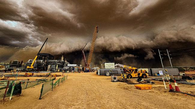
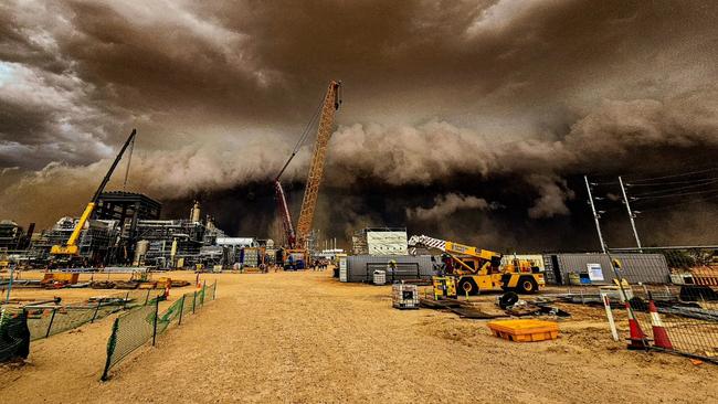
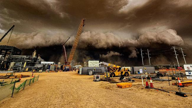
A vicious sandstorm has lashed outback South Australia, sparking extraordinary apocalypse-style scenes at one of the state’s biggest gas fields.
Astonishing photographs, which local fly-in fly-out worker Dylan Barlow captured, show huge dark clouds rolling into the Moomba oil and gas fields, in the state’s Far North.
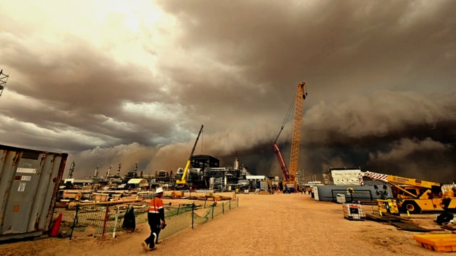
The sandstorm, which lasted an hour, forced workers into shelter as it lashed the Santos plant, almost 100km of Adelaide, before they were sent back to their camp.
It is unclear if any damage from the storm, which is believed to be a consequence from ex-Tropical Cyclone Kirrily.
Mr Barlow, 31, a rigger from Kalangadoo, near Mt Gambier, in the state’s South East, said the storm was hard to comprehend as it rolled in at 1.45pm on Sunday.
He said winds reached more than 90 km/h as workers raced to secure items.
“You could just see it coming and you just thought ‘this is not going to be good’,” he said.
“It was 42C and then suddenly the temperatures dropped. The winds picked up and then these dark clouds appeared. We had to race to get inside so you weren’t hit with it.
“You couldn’t see right in front of you, it was that thick.
“It lasted about an hour and then it just constantly rained with rain for the next four hours.”
He said another storm a month ago sparked wind gusts of more than 140km/h.
Adelaide’s scorching Sunday
Cool winds will sweep through the state, bringing temperatures down to the mid 20s early this week after a scorching start to February over the weekend.
In the city, above-average temperatures are expected to peak at 36C on Sunday before dropping down in the afternoon to hit 25C on Monday.
Bureau of Meteorology senior meteorologist Mark Anolak said while the change wouldn’t be instant, it would help take the edge off Sunday’s hot weather.
“We won’t really see temperatures drop very quickly this afternoon but temperatures will gradually continue to lower,” he said.
“For Adelaide itself, we’re expecting that change to move through, probably around the middle of the day, early afternoon, which means we’ll see quite a temperature contrast across the metropolitan area given that it’s such a long, long section of coastline.
“So it’ll move over the southern parts around Aldinga probably around midday, reach the city early afternoon and will take some time before it reaches the northern suburbs of Elizabeth later in the day.
“For tomorrow (Monday) we are expecting a significantly cooler day, below average for this time of year at around 25C tomorrow.
“And the rest of the week will maintain this sort of onshore air stream so temperatures will be below average for the rest of the week, 26C Wednesday, 27C Thursday so pretty stable pattern once we get through today.”
Temperatures will continue to creep back up into the weekend with tops of 26C on Friday and 29C on Saturday.
Outside of Adelaide it will be a lot hotter. In Port Augusta it’s set to reach 45C on Sunday before dropping to 29C on Monday.
On the West Coast, Ceduna can expect a drop from 37C on Sunday to a top of 22C on Monday.
Moving East along the Eyre Peninsula, Whyalla will reach a maximum of 45C on Sunday before plummeting 20 degrees to 25C on Monday, while Port Lincoln is expected to reach 29C on Sunday before dipping to 22C on Monday.
Monday’s top temperature in Victor Harbour should be 31C on Sunday, with a cloudy 20C on Monday, while Murray Bridge should reach 41C on Sunday ahead of a much cooler 24C with chances of a thunderstorm in the late evening on Monday.


Encrypted apps, suspicious flights: How $250k courier unravelled
A gambling addict has met his fate in court after he was busted with 25kg of cannabis inside luggage at Adelaide Airport and it wasn’t his first time, a court has heard.
Read more

End of an era: Inside Adelaide’s dying notorious red light district
Once notorious for flamboyant street sex workers, it’s surrounding suburbs are transforming into something else; although nobody is yet sure exactly what.
Read more