
Small reprieve possible as roads remain cut, communities isolated
The Bureau of Meteorology has advised flood warnings remain in place across northern Queensland, but a temporary easing in heavy rainfall could give communities between Tully and Ayr a brief reprieve over the next few days.
QLD weather news
Don't miss out on the headlines from QLD weather news. Followed categories will be added to My News.
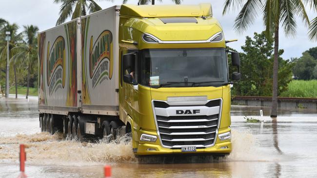
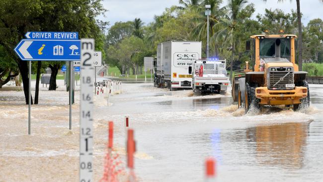
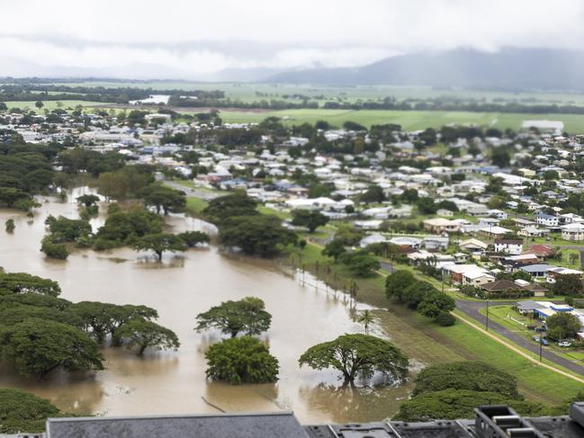
The Bruce Highway has been cut in multiple locations as flooding continues to wreak havoc in North Queensland. There are now more than 300 roads closed due to flooding.
It comes just days after North Queensland experienced a deluge “rarer than a one in 2000-year event”.
The Bureau of Meteorology has advised flood warnings remain in place across northern Queensland, but a temporary easing in heavy rainfall could give communities between Tully and Ayr a brief reprieve over the next few days.
“Isolated heavy falls are still possible with thunderstorms, but the more widespread heavy rain is likely to ease back just a fraction,” Senior Meteorologist Miriam Bradbury said.
“Another burst of very wet weather is on the way from early Tuesday morning, and that’s when we’re likely to see the six hourly rainfall rates along the east coast ramping up above 120mm once again, with 24 hour rainfall totals pushing towards 200mm.”
Gulf Country could see falls in excess of 150mm over the next 24 hours, while heavy rain is expected along the coast.
“We’re going to see the heavy rain building about the coast through the later part of today. By tomorrow morning, rainfall is expected to push throughout that warning area,” she said.
“We’re likely to see six hourly rainfall rates increasing to 120mm to 150mm across those inland warning areas, with 24-hour rainfall totals pushing towards 250mm.
“We may see roads become muddy or impassable or restricted to four-wheel drive access.”
As of 2.30pm, major flood warnings remain for the Cape, Upper Burdekin, Flinders, Haughton, Herbert and Western Rivers while moderate flood warnings are in place for lower Burdekin, Connors, Isaac, Bohle, Ross and Suttor Rivers.
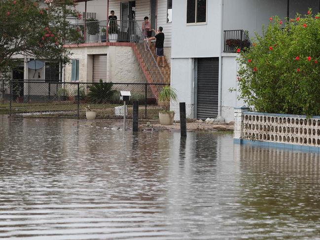
More than 2000 homes remain without power in Hinchinbrook, with authorities working to restore power to the region.
In Ingham, the showgrounds precinct is restricted to only emergency vehicles to assist in the management of the flood response.
The evacuation centre in Ingham has closed, with Hinchinbrook Council confirming all evacuees have now been placed into safe and secure accommodation.
Household wheelie bin services will recommence tomorrow for people living in Hinchinbrook, with all residents asked to leave bins on the kerb until they are emptied.
The Bureau of Meteorology on Sunday updated its severe weather warning for heavy rain, to include people in parts of Peninsula, Gulf Country, North Tropical Coast and Tablelands, Northern Goldfields and Upper Flinders and Herbert and Lower Burdekin forecast districts.
At 11am, the Haughton River at Giru sat at 2.23m, with moderate flooding. It was expected to dip slightly below that level in the afternoon but more torrential rain could send it soaring to major flood levels (2.50m) over the next few days.
The Bruce Highway on Sunday morning was cut from Silky Oak to Cardwell, Damper Creek to Gairloch, Coolbie to Rollingstone, Ayr to Mcdesme, Wangaratta Creek Bridge at Slater Creek and from Kelsey Creek to Lethebrook.
Heavy rain over the past week has also damaged the Bruce Hwy and multiple bridges.

Floodwater covered the Bruce Highway at Plantation Park before 2pm Saturday, only open to high-clearance vehicles and with police on site.
At 6pm Saturday Queensland Police advised the highway was closed to all traffic but the Burdekin Shire Council was looking to open the highway to heavy vehicles again at Plantation Creek Sunday morning.
The council’s local disaster management group issued an emergency alert on Sunday morning for the shire due to the predicted major flooding on the Burdekin River at Inkerman Bridge, despite downgrading that to a “stay informed” notice for residents in Giru as the floodwater along the Haughton River was ceasing.
Another major road that links the Cape York communities, Peninsula Developmental Road, was also closed from Mission River to Laura.
More than 300 roads across the state were forced to close due to flooding.
There were almost 3000 households still suffering blackouts Sunday morning amid the weather events.
Ergon Energy Network said it was challenging to take their crews, vehicles, equipment and generators to damaged sites spread over a 300km-long swathe of North Queensland.
“It’s been an incredibly tough week for them, and a massive week for our teams who have restored power to more than 30,000 properties from the Tableland to the Burdekin,” a spokesman said.
“As long as we can get them in, we’ll have 150-strong army working on power restoration, drawn from Atherton, Cairns, Cannonvale, Charters Towers, Home Hill, Innisfail, Mackay, Mossman, Pinnacle, Tully and Townsville, as well as Ingham depot’s local legends.
“As well as tackling restoration around Lannercost, Bambaroo, other hinterland rural localities and the remaining coastal areas, we’re trying to chopper a crew and ladders into Paluma to finalise resupply to this isolated community.
“At Helens Hill, where there are inaccessible powerlines down in the water, we’re aiming to bring in generation.
“We’re still aiming to get power back by tonight (Sunday night), weather and safe access permitting.”
It comes as a North Queensland town was bracing for the biggest flood in more than three decades, with the Burdekin River likely to reach major levels cutting the Bruce Highway.
Residents of Home Hill, which is 97km southeast of Townsville, are bracing for flood levels that haven’t been seen in more than three decades, with the Burdekin River expected to reach major flood levels on Sunday.
Home Hill is home to about 2800 people, according to the most recent data.
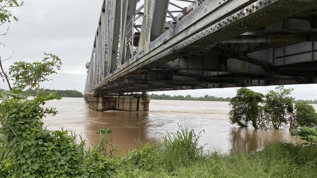
According to the Bureau of Meteorology, the Burdekin River at Inkerman Bridge, which connects Home Hill with McDesme, is currently above the moderate flood level of 10m and was expected to hit the major flood level of 12m on Sunday.
The Burdekin Bridge near Home Hill sat at around 11m Sunday morning.
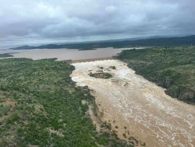
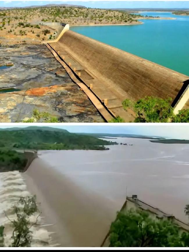
It comes as images of the Burdekin Falls Dam, on Lake Dalrymple, show huge volumes of water spilling over.
The dam - the state’s largest water storage asset - was sitting at 205.53 per cent capacity at 9am Sunday. Its highest recorded capacity was 221.15 per cent in February 1991.
The dam holds 1,860,000 mega litres.
Speaking with Channel 9’s Today on Sunday, Premier David Crisafulli said the Bruce Highway was once again cut, but North Queenslanders were resilient.
“It’s been really difficult for everyone involved,” he said.
“It’s been long and it’s been hard but we’ve seen the best of Queenslanders.
“My focus now will then be how we get out of the headache.”
Mr Crisafulli said that 300 electricity workers were deployed up north and reconnected more than 90 per cent of people to power.
He said their focus is moving towards Mount Isa as the system is predicted to continue in western Queensland.
Senior Meteorologist Miriam Bradbury said on Sunday morning there had been scattered thunderstorms in flood-hit regions.
“Severe thunderstorms were observed through parts of the Northern Goldfields and Upper Flinders district with high rain rates recorded through Saturday afternoon into the evening,” she said.
“However, rain areas with embedded storms increased about the northeast Tropical Coast, with a number of locations seeing over 100m in the space of about two to three hours.”
Ingham and its neighbouring towns were hit by massive rainbombs on Saturday, with Halifax suffering 274mm, 236mm plunging Gairloch, 193mm at Cardwell Fap and 150mm affecting Ingham itself.
Ms Bradbury said wet weather would continue for much of northern Queensland.
“The North Tropical Coast will remain the focal point for heavier falls through Sunday,” she said.
“A severe warning remains in place from Tully to Ayr, highlighting the area which might see the heaviest fall this morning encompasses the communities of Townsville, Rollingstone, Ingham, Cardwell and Halifax.
“Within that warning area, six-hourly rainfall totals may exceed 120mm today, with 24 hour totals approaching 250 mm.
“These heavy falls may continue into the new week, but may also come in bursts throughout the day today and going into tomorrow.”
Following the bureau’s warning for major flooding along the Burdekin River, the LDMG advised residents and business owners in the region to prepare now.
Burdekin Shire residents were urged to take advantage of the sandbag locations, with sandbags available at the SES depots in Home Hill and Ayr.
Ingham could be impacted by moderate flooding on Sunday, with the Herbert River at the Ingham Pump Station forecast to reach the moderate flood level of 11m from late Sunday morning with forecast rainfall.
Halifax, which is 18km north of Ingham, faces the prospect of more major flooding, with the Herbert River forecast to potentially hit the major flood level of 5m on Sunday morning with forecast rainfall.

WHAT IS THE MONSOON?
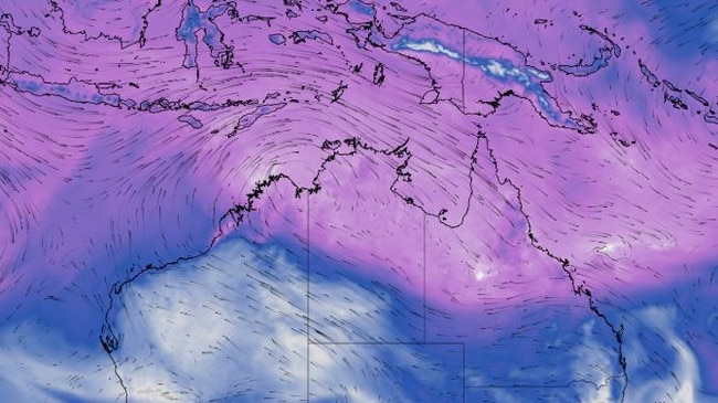
The monsoon refers to the seasonal reversal of the wind pattern over northern Australia, where the dry east to south-easterly winds that dominate for much of the year are replaced by west to north-westerly winds, Weatherzone’s Ben Domensino explains.
These monsoonal winds carry vast amounts of moisture laden air from the Maritim Continent and surrounding oceans towards northern Australia, typically resulting in periods of increased cloud and rainfall.
The monsoon usually fluctuates between active and inactive phases over northern Australia between November and April.
However, its onset date – the first time it arrives in each wet season – can vary quite a lot from year to year.
While the monsoon has already brought heavy rain to some areas in northern Australia this in the last few weeks, it has not yet arrived in Darwin.
In fact, this is now the latest monsoon onset on record for Darwin, easily beating the previous record of January 25 from the 1972-73 wet season.
Originally published as Small reprieve possible as roads remain cut, communities isolated

Ice ice baby: Spectacular images of unseasonal frost as Qld freezes
Queensland’s overnight temperatures will increase to double digits in the coming days, following the coldest start to winter in 16 years, bringing frost and ice to many regions. SEE THE PHOTOS
Read more

City’s coldest June start in 16 years, feels like MINUS 9.8C out west
Southeast Queensland is shivering through its coldest morning in more than 15 years but feels-like temperatures have dropped to insane levels in the southern inland.
Read more