
Queensland to thaw out after coldest June in 16 years
Queensland’s overnight temperatures will increase to double digits in the coming days, following the coldest start to winter in 16 years, bringing frost and ice to many regions. SEE THE PHOTOS

QLD weather news
Don't miss out on the headlines from QLD weather news. Followed categories will be added to My News.
Queensland is set to thaw out after shivering through the coldest June morning in 16 years earlier this week but temperatures continue to plummet overnight.
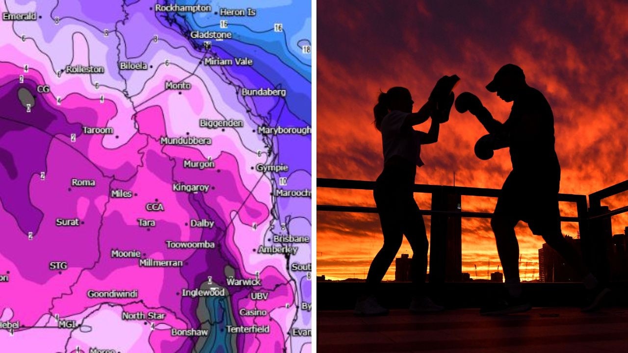
The mercury dropped to below zero in parts of the state, Wellcamp -4.3C, Warwick -3.4C, Oakey -4C and Roma -3.2C.
Applethorpe, Dalby, Kingaroy Goondiwindi also dipped below zero degrees overnight.
Jess Price, who lives 17km north of Injune took beautiful photos of the icicles at her family home on Saturday morning, after waking to a frosty -2.8C.
Brisbane’s minimum temperature dropped to 7.8C at 4am. By 6am the mercury was sitting at 8.6C but with an apparent temperature two degrees colder.

A weak high pressure system and associated ridge will continue to persist across Queensland, allowing a cool dry air mass to remain in place over much of the state.
Bureau of Meteorology Meteoroloogist Jonothan How there is a little bit of cloud across the south of the state, including around Brisbane, a little bit of high cloud rolling through.
“But we are expecting a mostly sunny and dry day, so temperatures climbing into the high teens to low 20s,” he said.
Mr How said temperatures are expected to dip close to or below zero across the south east tonight but minimums will begin to increase from Monday.
This comes as subzero temperatures and frost were recorded across the tropical regions of Queensland on Thursday, with Mount Isa recording its coldest June night in 44 years as it dropped to -0.7C. According to Weatherzone, Richmond experienced its lowest minimum temperature for June in 25 years with -0.1C, while Winton reached freezing point for the first time in 22 years.


“Tonight, we do see another cold night, but we gradually start to see these overnight temperatures warming up,” he said.
“From tomorrow will be another cold morning, but then from Monday, we’ll gradually start to see those overnight minimums increasing.”
But a cloud band will develop over northern Queensland on Monday and extend over parts of eastern Queensland on Tuesday before contracting to eastern districts from Wednesday.
Which could over 50mm of rain to some parts of Queensland.
Mr How said “unseasonal” rainfall is expected for parts of Northern Queensland.

“It is the dry season, Any sort of significant rainfall is quite unseasonal for this time of year, thankfully the rain will be over in a day or two,” he said.
“There is areas of showers and thunderstorms and rain building in areas north of Cairns and we will see those showers dropping down to Townsville, Mackay, Rockhampton on Tuesday and Wednesday.
“Cairns could get between 20 to 30mm of rain but further in land, we could see higher falls of more than 50mm across The Cape York Peninsula, further South Townsville, Bowen and Mackay 5 to 15mm.”

Originally published as Queensland to thaw out after coldest June in 16 years

City’s coldest June start in 16 years, feels like MINUS 9.8C out west
Southeast Queensland is shivering through its coldest morning in more than 15 years but feels-like temperatures have dropped to insane levels in the southern inland.
Feels like MINUS 6.5C out west as Brisbane faces brutally cold, windy 24 hours
Residents in parts of southern Queensland have woken to their coldest morning of the year, with temperature dropping below zero in a number of places.