
Cyclone Alfred: Alfred performs second pirouette during slow, destructive path towards SEQ
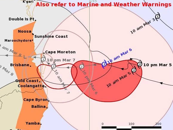
Tracking data released late Thursday night has delayed the arrival of Tropical Cyclone Alfred once more, with the slow-brewing monster set to unleash torrential rainfall on the southeast this evening.
QLD weather news
Don't miss out on the headlines from QLD weather news. Followed categories will be added to My News.
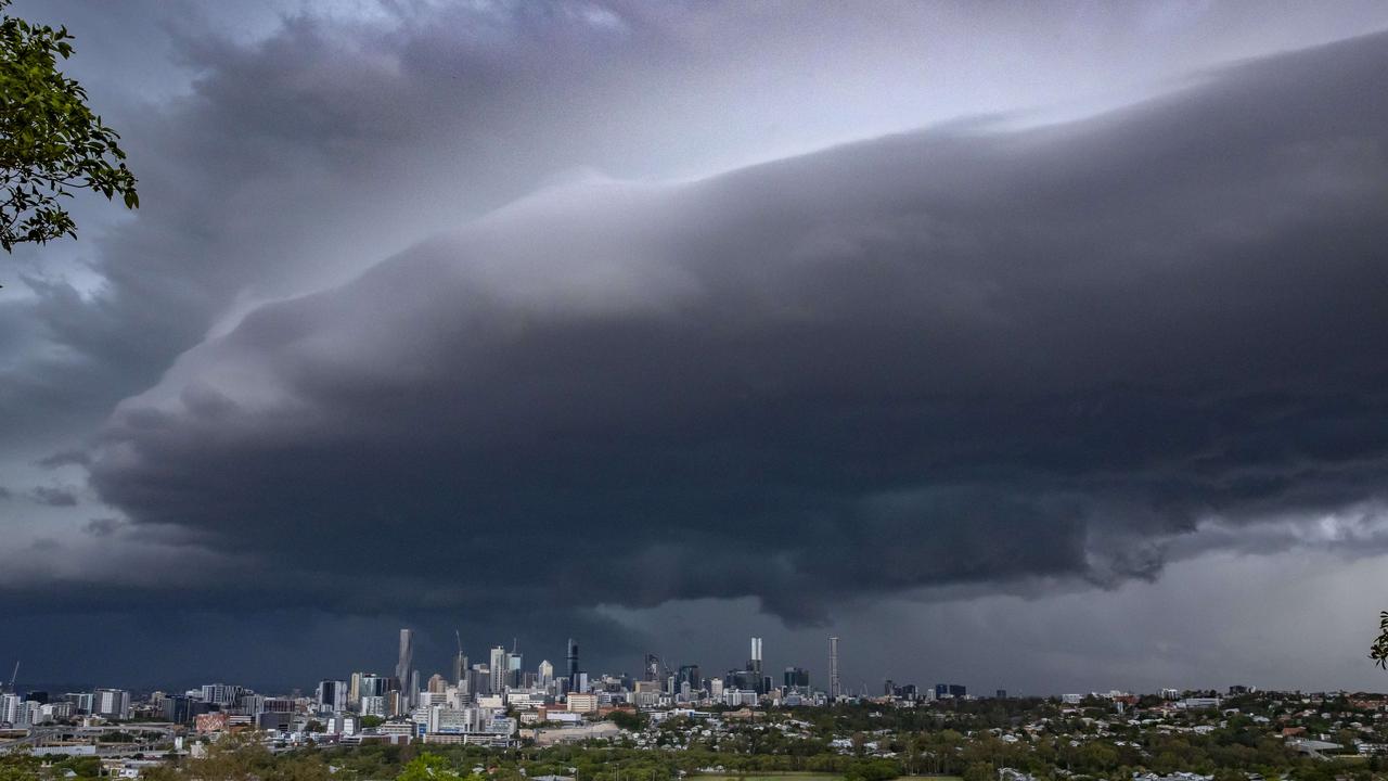
Tropical Cyclone Alfred has performed its second pirouette as it forges a slow and destructive path towards South East Queensland.
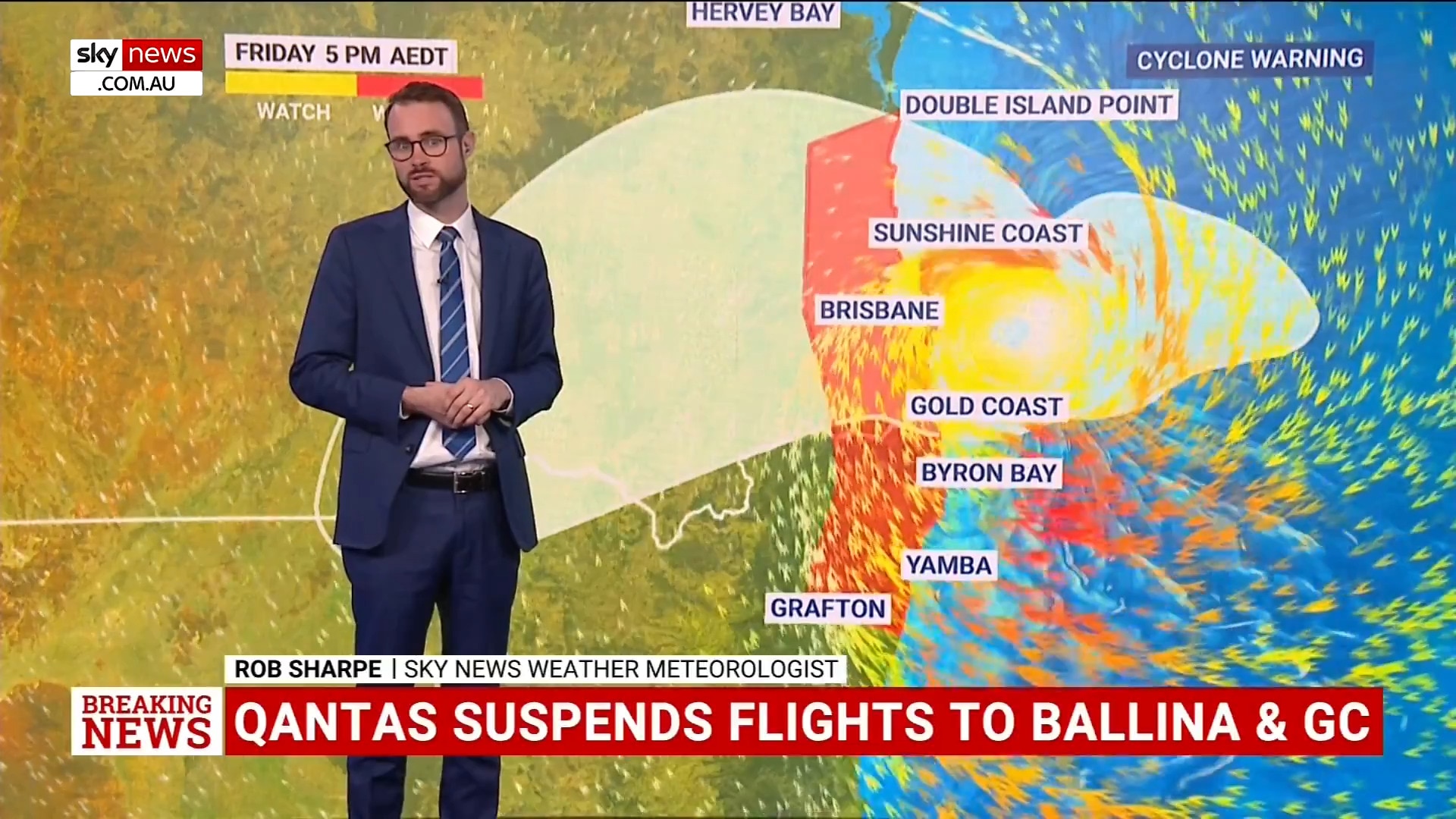
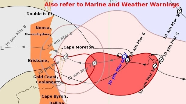
The latest tracking data from the Bureau of Meteorology, released just before 11pm, showed Alfred would make landfall near Redcliffe, slightly further north than previously indicated.
The modelling had Alfred moving through the City of Moreton Bay in the early hours of Saturday morning.
The modelling also showed Alfred had spun back around to the east for the second time.
“Alfred is currently category 2 and is expected to remain of similar intensity until the centre starts to interact with the coast and islands,” the bureau said.
Damaging winds of up to 120km/h were developing near the coast between Cape Moreton and Cape Byron, while gales were predicted to develop across coastal and island communities between Noosa and Ballina into Friday morning.
These dangerous winds were expected to persist throughout Friday, before easing late Saturday morning.
The bureau warned destructive gusts of up to 155km/h may develop about coastal and island locations near, and to the south of, the cyclone centre, as Alfred’s destructive core approaches the coast.
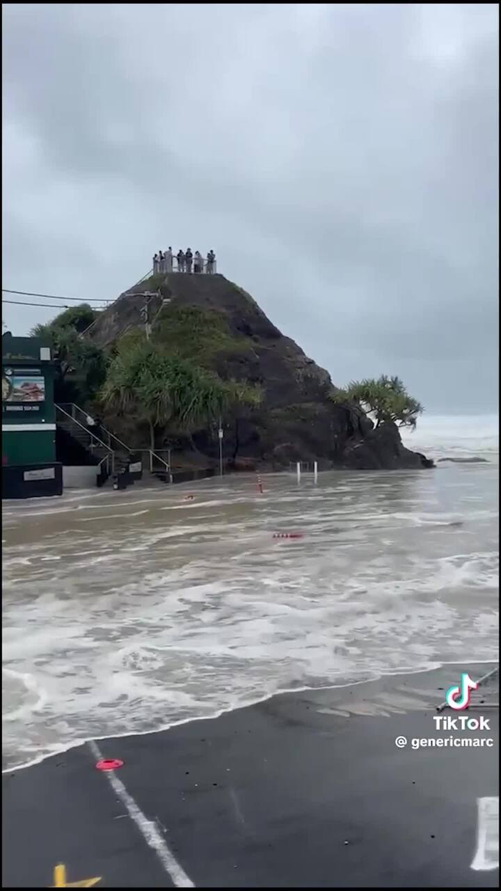
Dangerous storm tides along the coastal foreshore between Cape Moreton and Yamba are likely, with tides expected to rise far above the high tide mark and threaten to overwhelm low-lying areas.
These abnormally high tides will likely continue to cause minor flooding of coastal areas between Double Island Point and Grafton, particularly during the time of high tides early Friday morning and early Saturday morning.
Six-hourly rainfall totals between 60mm and 120mm were likely, and could increase to 180mm around Scenic Rim and Gold Coast Hinterland.
Twenty-four-hour rainfall totals between 100mm and 180mm are likely and could increase to around 300mm to 350mm for Scenic Rim and Gold Coast Hinterland.
The rainfall is expected to extend further north and west during Friday.
It comes after major airlines suspended all Brisbane and Gold Coast flights until at least Sunday.
Qantas, Jetstar and Virgin have all made the call to cancel domestic flights for at least the next two days, with Jetstar’s international routes suspended until at least Saturday.
The suspensions for Qantas and Jetstar also apply to Ballina, but not the Sunshine Coast, where flights continue to operate.
In a statement, a spokesperson for Virgin said all scheduled flights involving Brisbane, Gold Coast and Ballina would be impacted over the coming days.
“We are proactively reaching out to all impacted guests booked to travel during this period to re-accommodate their flights with us,” the spokesperson said.
“While closely monitoring the weather systems and forecasted timing, we are preparing our operation with a focus on ensuring our people are safe, and our aircraft are stored appropriately.
“We encourage all guests flying to or from South East Queensland and northern NSW this week to regularly check their flight status on the Virgin Australia website for updates.”

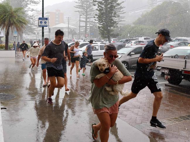
Alfred has hammered the Gold Coast today amid warnings it could take six hours to cross the mainland when it arrives, after its expected landfall time was pushed back again.
Experts say the slowdown is “most likely bad news” as it would extend extreme conditions, potentially causing billions of dollars worth of damage.
Wind gusts of more than 63km/h have been recorded at the Gold Coast Seaway on Thursday but these are expected to increase steadily throughout Thursday to over 92km/h overnight.
At Cape Moreton, gusts reached 98km/h, while they got to 82km/h at Double Island Point.
WATCH DAVID CRISAFULLI’S LATEST ADDRESS BELOW
#LIVE: I’m delivering an update on Tropical Cyclone Alfred https://t.co/kWkhsXnEAr
— David Crisafulli (@DavidCrisafulli) March 6, 2025
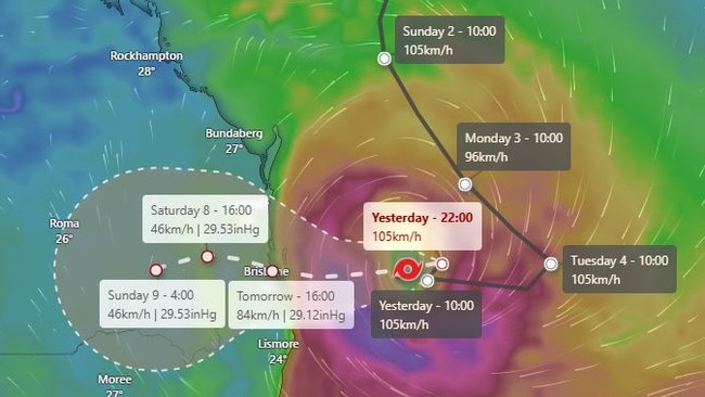
Premier David Crisafulli said Cyclone Alfred was 240km east of Brisbane, continuing to move towards the coastline at 7km/h, at 3pm on Thursday.
He said it was still set to cross the Queensland coast late Friday into the early hours of Saturday.
“Those winds will intensify but it shows that the system does continue to track towards the coast and continues to provide some challenges with the wind speeds.”

Bureau of Meteorology meteorologist Matt Collopy said the centre of the system was expected to cross the bay islands late on Friday or early Saturday and then on to the mainland during Saturday.
“The system is expected to impact the outer edge of the bay islands as a category 2 system,” he said.
Mr Collopy said “exposed coastal locations” could see wind gusts up to 150km/h late Friday into Saturday.
“We have already seen damaging wind gusts … those winds are expected to continue increasing as we move through today,” he said.
“We’re starting to see some of the heavy rainfall push across the Gold Coast and then stretch up through the Scenic Rim, along the bay islands and into Brisbane.”
Mr Collopy said the movement and strength of TC Alfred was “extremely complex”.
Mr Collopy said there was “very low probability” that TC Alfred would increase in speed overnight.
“As it approaches the coast, as it moves across the islands and gets into that complicated area we will see the system do some unusual things,” he said.
“The current forecast has a category 2 system as it just gets to the outer islands off Moreton, it does start to decay so the strength as it crosses the island is expected to be somewhere between that category 1 and category 2
“It is too early to say exactly which side of that threshold it will fall.”
Acting Police Commissioner Shane Chelepy said there were concerns significant rainfall would cause “flash and riverine flooding”.
In the past 24 hours there had been 184mm of rain at Upper Running Creek, 114mm at Springbrook and parts of the Sunshine Coast received 77mm.
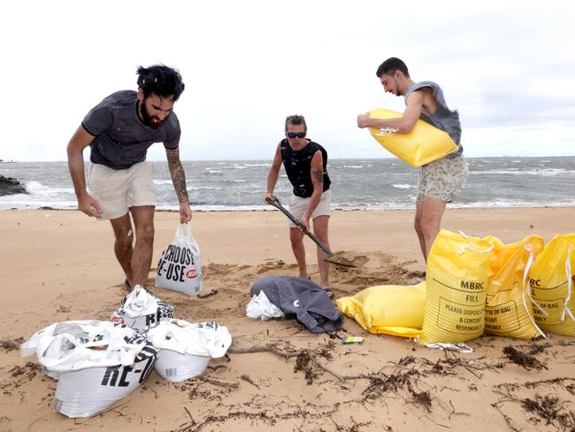
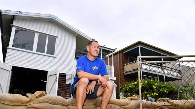
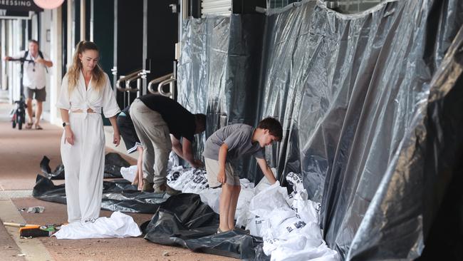
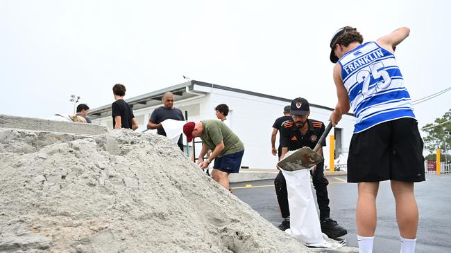
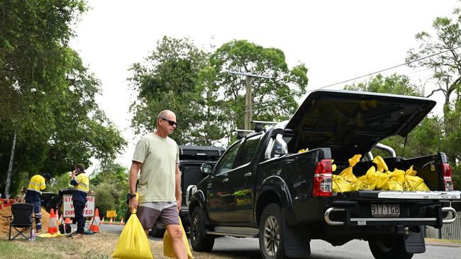
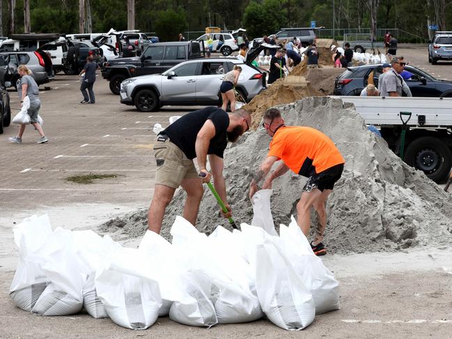
Mr Crisafulli said there had been more than 700 requests to SES for assistance, the vast majority around preparing homes such as sandbagging.
“If you are vulnerable, if you are unable to assist yourself, 132 500 is the number for the SES,” he said.
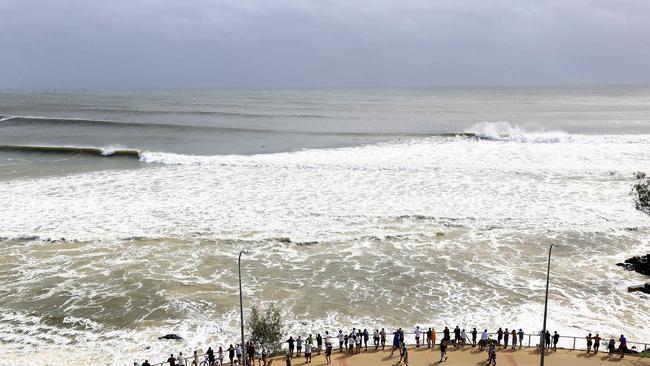
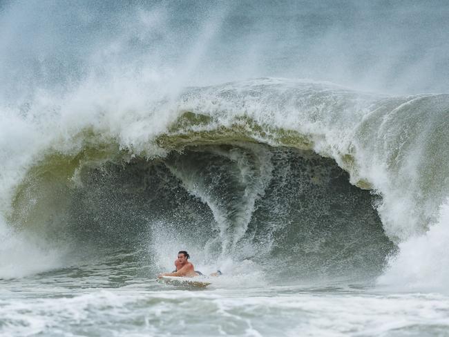
The Gold Coast wave monitoring buoy, which recorded a monster 12.3m swell overnight on Thursday, has been taken offline after being damaged by the pounding surf.

A search was launched on Thursday afternoon for a jet-skier feared missing in the wild seas off Tweed Heads.
NSW and Queensland police and the Westpac rescue helicopter were involved in the searc after reports a jet ski was seen floating in the surf near the mouth of the Tweed River.
“During the search, a jet ski rider entered the channel from the east before allegedly failing to stop for police and continuing west into the Tweed River,” a Tweed-Byron police spokesman said.
“As inquiries continue, police wish to speak with the rider of the jet ski to ascertain his movements at the time of the initial police report.
“No other jet skis were located during the search and police have not received any missing person reports at this stage.
“As inquiries continue, anyone who might have been riding a jet ski at the time of the incident is urged to contact Tweed Heads Police.”
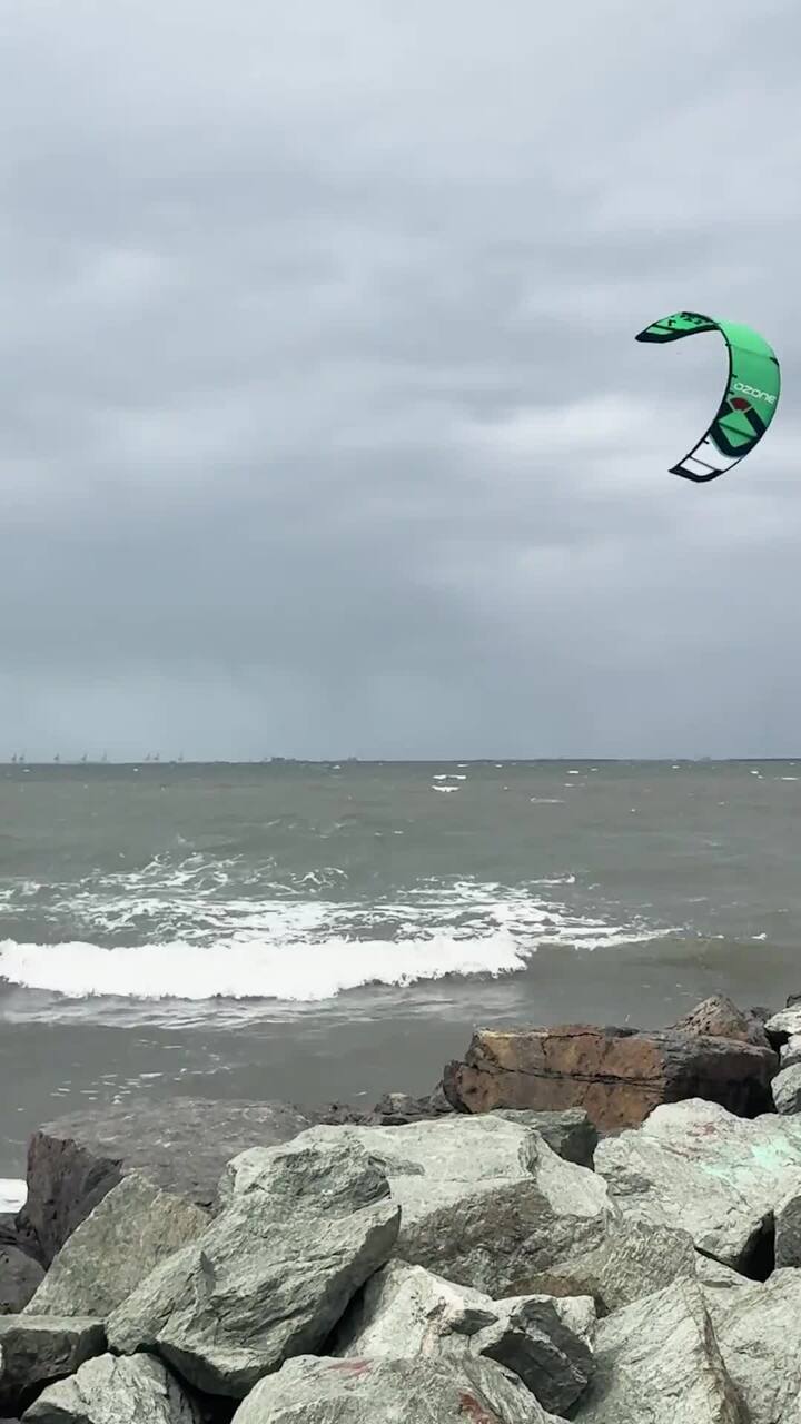
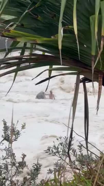
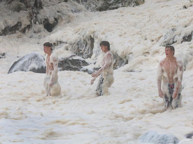
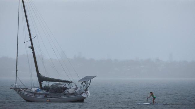
Experienced surfers have been using jet skis to tow each other into the monster waves whipped up by Cyclone Alfred.
A 7.12m wave was recorded off Tweed Heads at 11.30am on Thursday while a 5.43m wave hit Palm Beach.
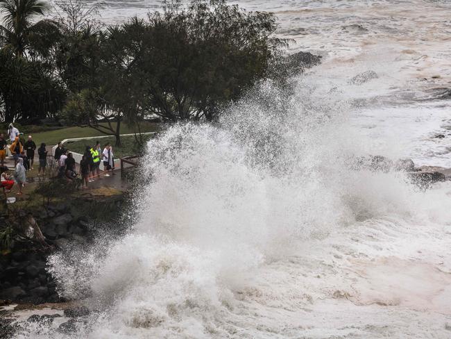
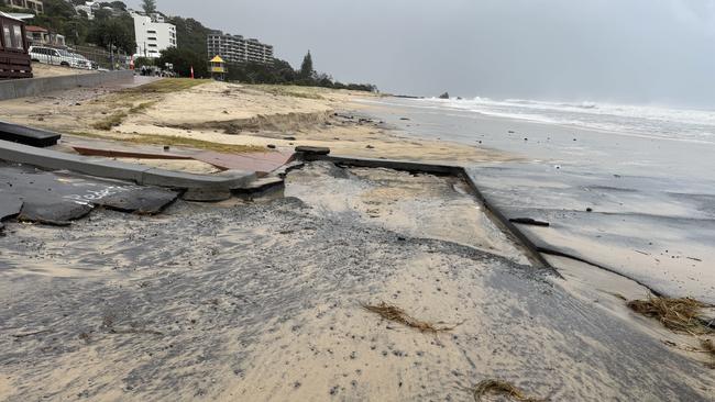
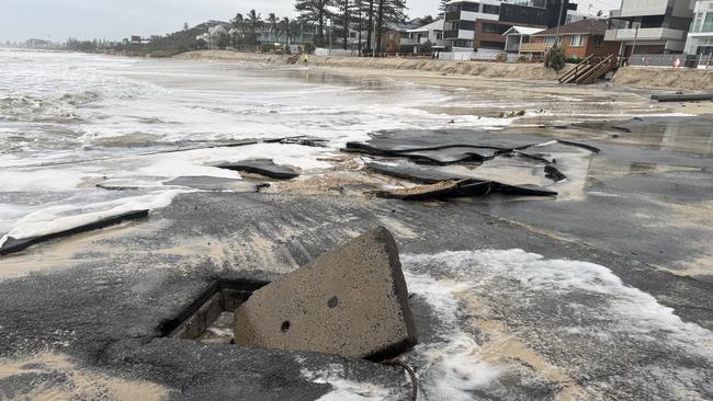
On the Gold Coast, waves of whitewater have today washed through the Currumbin Vikings Surf Club carpark, further smashing already badly-damaged bitumen.
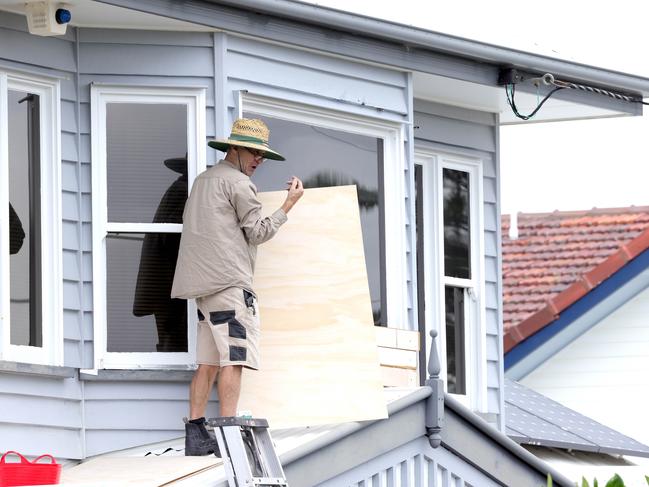
The iconic oceanfront Burleigh Pavilion resembled a heavily fortified bunker with windows boarded up and piles of sand bags stacked around doorways and entrances ahead of an expected high tide just before 2pm.
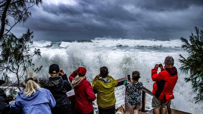
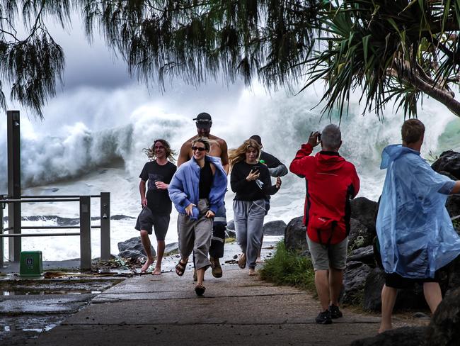
Curious onlookers packed a rain-soaked Burleigh headland posing for cyclone selfies, while a handful of hardy surfers braved the waves.
At Hedges Ave, the Gold Coast’s exclusive Millionaire’s Row, huge waves carved massive chunks out of the sand dunes, but even at Thursday’s high tide, the water was still well short of the beachfront mansions.
Storm tourists are defying road closures and flocking en masse to the Gold Coast Spit rock wall to witness the ferocity of wild swells whipped up by Cyclone Alfred, despite winds gusting up to 80km/h.
Cars have been abandoned on the sides of Seaworld Drive at Main Beach as storm watchers bypass barricades blocking traffic from Muriel Henchman Drive to make the 2km trip to the northern most tip of The Spit on foot.
The floods of people - some clad in ponchos while others walk topless - include parents with very young children.
Earlier, Mr Crisafulli highlighted the system’s four key threats – waves, wind, rainfall and flooding.
PREMIER, EMERGENCY SERVICES GIVE ALFRED UPDATE: WATCH BELOW
It comes after NSW Premier Chris Minns, speaking in Lismore, said: “The window for destruction in our community – heavy rains, winds, powerful surf – is longer than we would have otherwise”.
Meteorologists warn the slower speed of Alfred’s advance means east coast communities are in for “extended and more prolonged period of significant and major wave heights and heavy rain”.
Qantas and Jetstar suspended all flights in and out of Brisbane, but the airport would remain open until the last service at 4pm.
Brisbane Lord Mayor Adrian Schrinner said the delay in Alfred’s arrival meant Brisbane’s sandbagging stations would reopen, after closing at 8pm on Wednesday.
The seven temporary “fill-your-own” sites – Acacia Ridge, Toowong, Camp Hill, Boondall, West End, Darra, Murarrie (scroll down for full address details) – will be reopened from 10.30am and will remain open until further notice.
Premier addresses Qld: Alfred arrival pushed back, power outages begin
Mr Crisafulli said the cyclone remained a category 2 system as it tracked towards the coast.
“Overnight we saw the system spin around on itself and now it has resumed its journey into the coast,” he said.
“The area at the moment is between the Sunshine Coast and the Gold Coast, it will tighten.
“We have a plan in place and we are asking you to have a plan in place as well.”
Mr Crisafulli urged Queenslanders in the impact zone not to become complacent.
“The advice from authorities is that the system does continue to move here,” he said.
“Its current movement has resumed that westward track towards the coast … this erratic movement has resulted in a delay to forecast crossing,” he said.
“It approaches the outer islands very late on Friday and is expected to cross the coast in the early hours of Saturday with the most likely track still between the Sunshine Coast and Gold Coast near Brisbane as a category 2 system.”
Mr Collopy said the cyclone would take 3-6 hours to cross the coast, but there was the possibility it could take longer.
He said the system would drench the southeast from Thursday afternoon into Saturday.
“Typically, tropical cyclones as they cross are very erratic, but we are expecting two days, perhaps two-and-a-half days worth of rainfall as this system both approaches, weakens, and then moves inland,” he said.
Mr Collopy said strong winds could linger if the system stalls, but predictions indicate it would weaken as it approaches land.
He said if it crossed at “exactly high tide there is the risk of seeing storm surges up to 1.5 metres”.
Acting Police Commissioner Shane Chelepy said emergency services were positioned from the Sunshine Coast to the Gold Coast, ready to respond.
Australian Defence Force personnel will be on the ground after the cyclone hits the southeast.
High-clearance vehicles will be used and two ADF helicopters will help with search and rescue.
Twenty-five refuge locations were located across all southeast Queensland councils in the impact area.
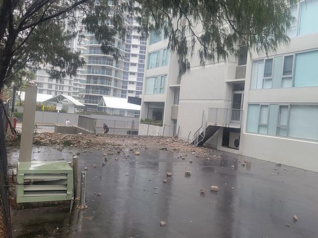
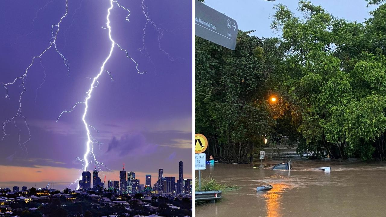
Power outages have already started with strong winds knocking down trees onto power lines.
At 11.30am, more than 5000 homes – mainly on the Gold Coast – were without power.
Mr Crisafulli said the government would keep roads and bridges open for as long as possible for emergency services.
“As the system continues to move in, my message to Queenslanders … the best place to be is at home,” he said.
More than 1000 schools and 324 early learning centres remain closed today and Friday.
Mr Crisafulli said 34 water treatment plants across the region had been fortified and back-up generators were ready. Public transport would also remain closed today and Friday.
It comes as authorities warn millions across South East Queensland to bunker down at home, and those with no other option to head to evacuation centres, as an increasingly unpredictable Alfred brings destructive winds and flooding.
Category 3 chances reduce, but still a chance
Bureau of Meteorology meteorologist Sarah Scully said there was a 5 per cent chance Alfred could intensify to a category 3 system.
“The cyclone has been steered by a high-pressure system … the steering winds did just drop off overnight and it has stalled,” Ms Scully said.
“It has resumed and is moving with a trajectory towards the South East Queensland coast.”
Parts of northern NSW have already been impacted by heavy rain, with 200mm recorded at Dorigo and 170mm at Mullumbimby.
Ms Scully said gale force winds were expected to increase today and tomorrow as the system moved closer to the coast.
She said the cyclone had a low chance of intensifying.
“There’s a 5 per cent chance it may increase to a category 3.
“It will most likely cross as a category 2 and the path is still expected most likely between Brisbane and the Sunshine Coast.”
Slowdown ‘most likely bad news’
Bureau of Meteorology senior meteorologist Dean Narramore said heavy rain and massive surf would lash the coastline for longer as Tropical Cyclone Alfred stalled off the coast.
“We’re going to have an extended and more prolonged period of significant and major wave heights, leading to significant coastal erosion in north east New South Wales and south east Queensland,” Mr Narramore said.
“The other impact means we are going to have a longer and more prolonged period of heavy rain.
“That’s going to continue right through Thursday, Friday and Saturday, and this means major flooding in many rivers in northeast New South Wales, and moderate to major flooding in parts of South East Queensland as well.”
Since 9am Wednesday, 110mm of rain fell in Springbrook and 179mm fell on the upper regions of the Logan and Albert Rivers.
Meteorologist Tony Auden said recent changes to Alfred’s path and speed were “a reminder of how erratic tropical cyclone movement can be,” adding that he expected it to cross the coast on Saturday after a major stall.
“Looking ahead, almost all model guidance has made a significant change to the forecast track,” he said.
“It looks like Alfred will stall off the coast on Friday, rather than crossing, then likely move over land on Saturday. It’s all due to the next upper trough approaching from the west.
“Things are becoming a lot less certain in the forecast track, so expect more changes, [but] it’s most likely bad news, as Alfred will hang around for longer.”
Mr Auden said strong winds and large waves would likely hang around on the coast for longer, possibly for most of the weekend, with heavy rain expected closer to Saturday.
“We could get a sideswipe with heavy rain late tomorrow and Friday, but the heaviest falls, and peak of the flooding are likely around a landfall,” he said.
“At this stage that looks more likely into Saturday. Latest guidance brings the low a bit further north, so all catchments in South East Queensland (and still for northern NSW) could be in the firing line.”
310,000 sandbags delivered to Brisbane: PM
Prime Minister Anthony Albanese said 310,000 sandbags had already been delivered to Brisbane, with more on the way.
“60 ADF personnel and 30 high clearance vehicles are being pre-positioned … to support police and SES volunteers as we move to the recovery phase,” he said.
“We have activated the Australian Government Disaster Response Plan and crisis co-ordination team, which will operate out of here. I intend to operate out of here for the coming days, it is probably the best place I can be to make sure that there is seamless activity between New South Wales and Queensland.”
Moreton Bay Mayor Peter Flannery told ABC Radio the council was not considering reopening sandbag stations.
“There’s a huge shortage of sand. We’ve gone through 3,000 tons of sand and 300,000 sandbags,” he said.
Mr Schrinner said an additional 1000 homes would be impacted by flooding according to another round of modelling.
“That’s obviously based on the latest impact, so it’s a slightly higher impact than our first round of modelling,” he said.
Roadside assistance to halt from tonight
The RACQ has announced it will stop its roadside assistance services in southeast Queensland and as far west as Withcott in the Lockyer Valley from 7pm today, until further notice.
“Please stay off the roads today and do not drive again until authorities advise it is safe,’’ it said in a statement.
“We will not be able to attend any call-outs while Tropical Cyclone Alfred is impacting SEQ as it will be too dangerous for our operators.’’
The RACQ advised motorists in a life-threatening situation or who had become stuck on the side of the road to call triple-0.
The Department of Transport and Main Roads has also confirmed there were still no major road, bridge or tunnel closures in place across southeast Queensland.
TMR said it also would not pre-emptively close bridges and roads in the lead-up to Tropical Cyclone Alfred crossing the coast.
But it warned the combination of increased wind and rain could significantly affect safe travel because of poor visibility.
Alfred to cause damage costing ‘billions of billions’
Treasurer Jim Chalmers said the expected the damage bill from cyclone Alfred to be in the “billions and billions of dollars”.
“This is going to be a very serious weather event,” Mr Chalmers said.
“Don’t be complacent, people cannot be complacent. Do what you need to prepare.”
Mr Chalmers said he had spoken to the CEOs of multiple major insurance bodies overnight.
“They are putting in place the preparations they need to process claims,” he said.
“We need to be kind to each other, look out for each other, it’s going to be a really difficult couple of days but the weeks and months that follow will be hard as well.”
Mr Albanese said he will provide additional funding for both Queensland and New South Wales to aid with recovery from Tropical Cyclone Alfred.
“I’ll sign off on those in Parliament House immediately when this finishes, and that money will be on its way,” he said.
“That’s important, so that immediately there’s not a process of, there’s a road issued that’s been damaged by waters, and then we have a process of the bureaucracy dealing with these things.
“The money is on its way so that the work will continue absolutely immediately.”
Residents in flood zones – including the 20,000 households in Brisbane expected to be hit with some flooding – have been asked to ride out the storm with family or friends.
Mr Crisafulli said for those outside flood zones, the safest place to bunker down was in their homes.
“If you are in a storm tide zone, or in an area where you know there is riverine flooding, you really need to consider and think about your evacuation now,” he said.
Hundreds of police recruits and council workers doorknocked residents along the coastline on Wednesday, warning them of the dangers.
South East Queenslanders with no other options have been directed to evacuation centres across council areas.
Refuge centres opened
In Brisbane the RNA Showgrounds in Bowen Hills opened at 7am on Thursday as a refuge centre, the second time it has been used in a disaster in the past 100 years.
Mr Schrinner said the centre was not the same as an evacuation centre.
“This will be available to people who have no other options – it will be a very basic facility, this isn’t a facility with beds, it isn’t a facility for the long term, it’s designed to protect people’s physical safety during the most intense part of the cyclone,” he said.
“As we move forward, we will also be opening evacuation centres.”
Dozens of tables and hundreds of chairs have been prepared, and there are also toilet facilities and TVs.
Brisbane City Council said on Wednesday that the shelter will lock down after noon.
Redlands Mayor Jos Mitchell said the council would open refuge centres but not resourced evacuation centres.
Mr Crisafulli said the government was working to help homeless people find short-term accommodation.
People in aged care in low-lying areas were being evacuated, along with 68 people from South Stradbroke Island.
Despite the lack of evacuation centres in Redland, Logan has opened a 24-hour evacuation centre at Crestmead and will reopen sandbagging stations later today.
Logan Mayor Jon Raven said an evacuation centre would be open at the Logan Metro Sports Centre at 357 Browns Plains Rd.
“That’ll be open 24/7 for as long as people need it. There are beds available for those who require shelter, and everybody is welcome,” Mr Raven said.
In addition to the evacuation centre, Logan will re-open two places of refuge, providing essential services to those in need.
“They don’t have bedding, but they’re open 24/7,” he explained. “They have tea, coffee, someone to talk to, a place to charge your phone. You just can’t sleep there, that’s all.”
Rescue crews were on standby on the Gold Coast and in Brisbane, including 180 swiftwater rescue personnel, as well as helicopters with winch capability and Australian Defence Force assets.
Mr Crisafulli encouraged Queenslanders to inspect their yards and clean up loose debris.
“We are now into the phase where it is hours, not days … but you still have time,” he said.
Mr Crisafulli said residents also needed to prepare for road closures and for bridges to close as winds hit 90km/h.
Brisbane Airport flights to stop at 4pm
Brisbane Airport will continue operations until the last scheduled airline service today which was expected at 4pm on Thursday.
Travellers are advised to speak to their airlines and not travel to the airport for cancelled flights.
Terminals would remain open while passengers and essential airport workers need shelter, for emergency and aeromedical services, for defence operations and while it was safe to do so.
Airtrain services were suspended until further notice while dining and retail stores throughout the terminals, Skygate, DFO and Service Centre would be closing or were already closed.
Woolworths at Skygate would be shut at 2pm.
The Skygate and Terminal Transfer Bus service would continue as scheduled today.
Qantas and Jetstar flights from and to Brisbane were suspended from midday Thursday until at least Friday, while flights to and from Sunshine Coast and Harvey Bay will continue as scheduled.
A Virgin Australia spokeswoman said the airlines will operate a limited schedule to and from Brisbane on Thursday until 4pm
Terminals will remain open, however.
Originally published as Cyclone Alfred: Alfred performs second pirouette during slow, destructive path towards SEQ
Join the conversation
‘Everything was on fire’: Teen recounts being struck by lightning
A Southeast Queensland teen has recounted the horrifying moment she was struck by lightning during last night's wild weather, which saw her and another woman raced to hospital.
Read more
SEQ to be lashed with storms, 100mm downpour ahead of Anzac Day
Showers and storms are forecast to soak South East Queensland on Thursday afternoon with lingering rain expected to fall on Anzac Day Dawn Services and marches.
Read more