
Why did Cyclone Alfred stall off the Queensland coast? Four experts explain
Cyclone Alfred has once again stalled and done a full pirouette overnight with experts revealing what it means for landfall.

QLD weather news
Don't miss out on the headlines from QLD weather news. Followed categories will be added to My News.
Cyclone Alfred has once again stalled and done a full pirouette overnight, slowing down to just 3km/h.
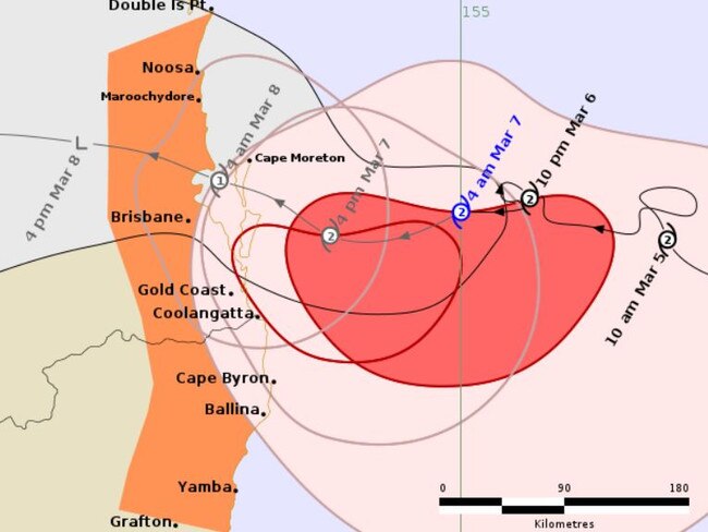
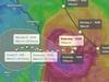
Its projected path remains aiming for a direct hit on the South East Queensland coast, but its expected arrival time has again been pushed back, this time to Saturday morning.
On Thursday, after it slowed its track to southeast Queensland to a crawl overnight on Wednesday, we asked four experts what that could mean for the system’s impact.
And it’s not good news.
Helen Reid
The Bureau of Meteorology
Bureau of Meteorology meteorologist Helen Reid said Tropical Cyclone Alfred’s run to the Queensland coast slowed due to a lack of influence from a separate weather system.
“There was a little bit of meandering and no distinct movement in any direction over the night and that was because of not having any steering in the upper atmosphere or elsewhere to help it move,” she said.
“Tropical cyclones are their own little system, they need to be moved along by something else.
“So that period overnight, we saw it just hovering in the same place for that period.”
Ms Reid added the lack of movement overnight will mean another day of exposure to strong winds for coastal areas.
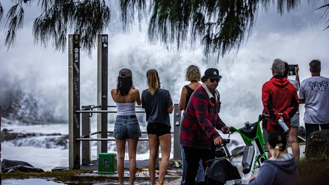
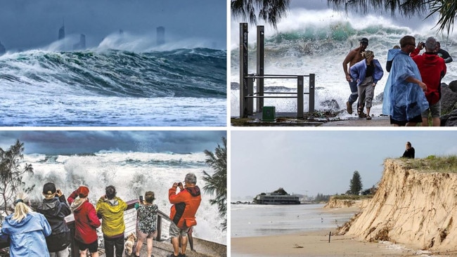
“The impact will be most felt by the coastline, those waves have been able to crash in for an extra day meaning coastal damage and erosion there,” she said.
“It’s also another day of those storm force winds out on the waters as well, so all those offshore impacts have just been continued for a day.”
Ms Reid said the latest modelling shows Tropical Cyclone Alfred is still tracking towards the Queensland coast.
Tony Auden
Channel 7
Channel 7 meteorologist Tony Auden said the slowing down of Tropical Cyclone Alfred has had a big impact on its forecast track.
“First, we’ve had a reminder today (Wednesday) of how erratic tropical cyclone movement can be, with big wobbles in Alfred’s path this afternoon,” Mr Auden said.
“Looking ahead, almost all model guidance has made a significant change to the forecast track. This is only partially reflected in the current BOM track, as they keep a lot of older guidance in their data to minimise rapid changes (a good idea to minimise false rapid changes most of the time, but it does mean that changes like this take a while to be reflected in the official forecast).
“In short, it looks like Alfred will stall off the coast on Friday, rather than crossing, then likely move over land on Saturday.
“It’s all due to the next upper trough approaching from the west.”
Mr Auden said the slowing down of the category 2 system potentially means “Alfred will hang around for longer”.
“Things are becoming a lot less certain in the forecast track, so expect more changes,” he said.
“It’s most likely bad news, as Alfred will hang around for longer.
“Large waves will likely hang around longer into the weekend.
“With a delayed coastal crossing, we need to wait for updated timing to assess the storm surge risk.
“Strong winds will likely hang around on the coast for longer, possibly for most of the weekend.”
Marina Neuman
Sky News Weather
Sky News Weather meteorologist Marina Neuman said while Tropical Cyclone Alfred has slowed significantly, there is a chance the category 2 system could intensify.
“Well, the cyclone has slowed dramatically in the last few hours, we had previously been saying the timeline for the system to make landfall would be between Friday and Saturday,” she said.
“At one point, early this morning (Thursday), it did look to make landfall a bit sooner, but that has once again changed with the system nearly stalling just off the coast of Queensland, so it is currently moving very slowly.
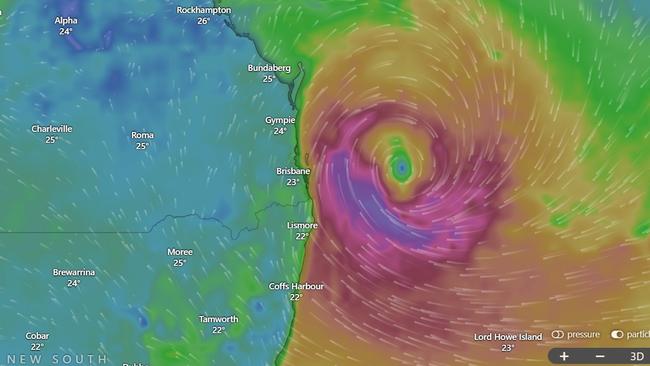
“It’s still just a category 2 storm, but it is starting to strengthen a bit, we’re seeing the winds at 130 km/h at this moment in time.”
Ms Neuman said rainfall totals and wind speeds were expected to increase from Thursday.
“We could really start to see coastal erosion, very high storm surge and then we’re also looking at the potential for about 500 to 700 millimetres of total rainfall,” she said.
Thomas Hinterdorfer
Higgins Storm Chasing
Thomas Hinterdorfer of Higgins Storm Chasing said while Tropical Cyclone Alfred slowed down, it was still expected to make landfall in Queensland.
“Alfred did a bit of a wobbly on everyone yesterday (Wednesday), it did a little bit of a loop and slowed down and stalled for a bit – basically, all that’s done is delayed the inevitable,” Mr Hinterdorfer said.
“It hasn’t changed too much, it’s just everything’s been delayed.”
Mr Hinterdorfer attributed the slowing down of Tropical Cyclone Alfred to “competing steering ridges”.
“The main reason for that slowdown and stall was just a temporary conflict of steering ridges and patterns,” he said.
“The steering of the system just got interrupted for a bit, just by some competing steering ridges.
“It means that it’s going to be a bit slower moving towards South East Queensland.
“Everything has just been delayed, that’s all it is, the inevitable is still coming.”


Ice ice baby: Spectacular images of unseasonal frost as Qld freezes
Queensland’s overnight temperatures will increase to double digits in the coming days, following the coldest start to winter in 16 years, bringing frost and ice to many regions. SEE THE PHOTOS

City’s coldest June start in 16 years, feels like MINUS 9.8C out west
Southeast Queensland is shivering through its coldest morning in more than 15 years but feels-like temperatures have dropped to insane levels in the southern inland.