
Countdown to Alfred’s impact: Power cuts, major flooding, millions told stay home
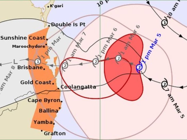
Cyclone Alfred will cross the South East Queensland coast later than previously estimated, according to the latest weather bureau estimate.

QLD News
Don't miss out on the headlines from QLD News. Followed categories will be added to My News.
Schools will close, millions have been told to stay off the roads and public servants ordered to work from home as Tropical Cyclone Alfred’s arrival nears.
On Wednesday night the Bureau of Meteorology updated its estimate for when the cyclone would cross the coast.
The latest BoM modelling suggested that while Cyclone Alfred was still on track to make landfall on Friday, it could potentially cross the coast later in the day than previously indicated.
Cyclone Alfred is forecast to maintain category 2 intensity as it continues to approach the coast, with the crossing most likely between Maroochydore and Coolangatta.
The Bureau of Meteorology has warned of a dangerous storm tide and life-threatening flash flooding with 24-hour rainfall totals up to 400mm. Almost 1m of rain could fall between Thursday and the weekend.
Millions could lose power for days, while those in low-lying areas across Brisbane, the Gold Coast and City of Moreton Bay have been urged to get ready to evacuate.
WATCH THE PREMIER, PRIME MINISTER AND BRISBANE MAYOR SPEAK BELOW
Weather bureau senior meteorologist Matt Collopy said the category 2 system was forecast to cross the South East Queensland between Brisbane and the Gold Coast, and that there was a “small chance” of it becoming a category 3 system.
Mr Collopy said gusts of up to 90km/h would develop later today “increasing to destructive winds, up to 130km/h gusts as Alfred approaches the coast and crosses later on Thursday and into Friday”.
Will my home survive Alfred? What the experts say
Do I have to go to work? Will my home flood? Your questions answered
“This is particularly for exposed locations around the coast and also the adjacent, elevated inland areas,” he said.
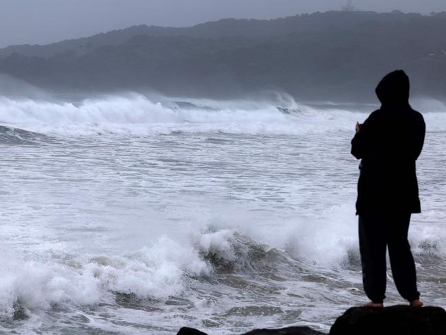
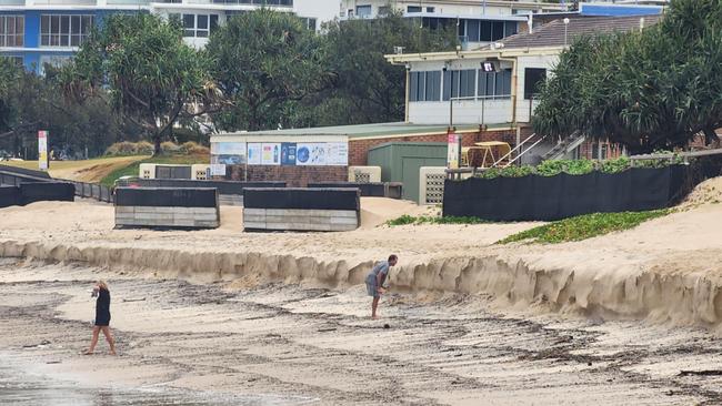
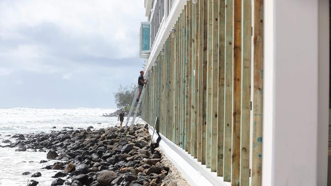
He said the coasts had already experienced severe erosion which would “likely get worse”.
“Tropical Cyclone Alfred is expected to produce a significant storm surge around the southern flank of the system … this means that as it crosses, likely near the high tide that happens in the early hours of Friday morning, we will see elevated sea levels between a half to one metre above the normal highest tides that people see,” he said.
Mr Collopy said the bureau had forecast “heavy to locally intense rainfall” well into the weekend with rainfall totals up to 800mm.
“This sort of rainfall is expected to produce life-threatening flash to riverine flooding,” he said.
Mr Collopy said there was a “small percentage” of the Bureau’s modelling which showed the system turning into a category 3.
“It’s expected to remain as a category 2 as it approaches, and at the higher end of that category.
“There is a small percentage of our modelling that does alert the risk of it strengthening further, but we will watch that very closely.
“At this stage, the most likely outcome is we will have a category 2 system cross the coast.”

Mr Collopy said hourly updates would be released to the public as the cyclone moved closer to the coast.
Falls of up to 400mm are anticipated as Alfred makes landfall on Friday, with six-hourly totals of between 200mm and 250mm, leading to possible life-threatening flash flooding.
The heavy rain will begin on Thursday, with the Bureau warning of the likelihood of six-hourly rainfall totals between 60mm and 110mm, and 24-hourly rainfall totals between 80mm and 180mm.
Logan watch and act, hospitals open, toll dropped
Hospitals south of Brisbane, including those in Logan and Redlands, will remain open around the clock to provide continuous care during the severe weather event.
However, the newly opened Redlands Satellite Health Centre at Redland Bay will close from 12 pm on Thursday and remain closed all day Friday.
Other services, such as the Wynnum-Manly Primary Care Clinic – Gundu Pa, will also close on Thursday, and clinics at Mt Gravatt, Inala, and Logan will temporarily shut their doors. Several community health centres across the southside will modify their hours or close entirely due to the approaching cyclone.
Despite the closures, health workers are committed to keeping both Redland and Logan hospitals open to ensure that critical services remain accessible.
Tolls on the Logan Motorway are expected to be lifted to guarantee free and full access to Logan Hospital during the weather event.
In response to the severe conditions, non-urgent surgeries and outpatient appointments scheduled for Thursday and Friday will be rescheduled.
Affected patients will be contacted directly. If weather conditions prevent a patient from attending their scheduled appointment, they are encouraged to contact the hospital to rearrange a new time.
For non-life-threatening conditions, the Virtual Emergency Care Service is available, offering virtual consultations with specialist clinicians.
This service, typically operating from 8 am to 10 pm daily, will extend its hours to 24 hours, beginning Thursday, March 6, at 8 am and running through to Tuesday, March 11, at 10 pm.
Residents can also call 13 HEALTH (13 43 25 84) for health advice at any time during the event. Authorities urge everyone to stay safe and prepared as the severe weather event approaches.
The properties most at risk
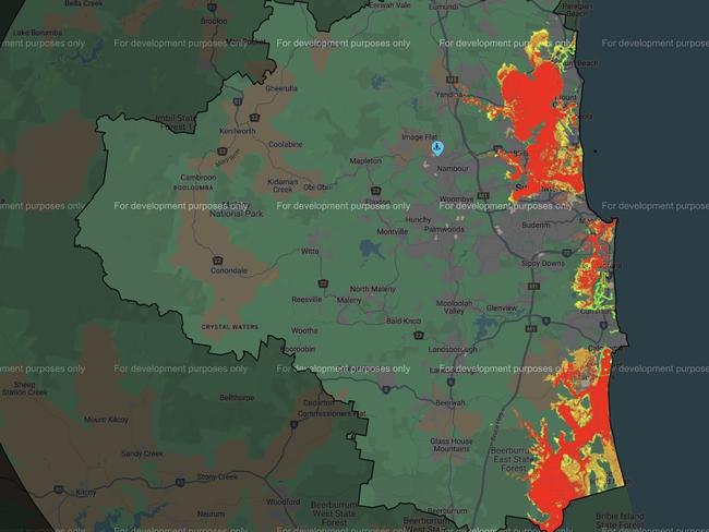
Sunshine Coast Council has urged residents to check out a storm tide map which shows the properties most at risk.
Storm surge modelling shows almost 1600 properties could be affected if a possible storm surge reaches half a metre above the highest astronomical tide.
Of those impacted properties, around 200 properties could potentially be impacted with inundation greater than 300mm.
If the storm surge gets to a metre above Highest Astronomical Tide, 4600 properties may be impacted, with around 670 properties potentially impacted with inundation greater than 300mm.
Brisbane Airport remains open
Brisbane Airport remains open with scheduled airline services continuing to operate.
Some airlines are cancelling services and others will likely do so over the next 24 hours.
It will continue to operate its terminals as long as airlines schedule flights in and out, and for emergency and aeromedical services and defence, and while it is safe to do so.
School closures confirmed
Schools in SEQ will be closed on Thursday and Friday due to Tropical Cyclone Alfred.
The closures include schools in the Noosa, Sunshine Coast, Moreton Bay, Redlands, Brisbane, Logan, Ipswich, Scenic Rim and Gold Coast local government areas, and parts of the Darling Downs
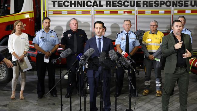
Premier, Prime Minister, Brisbane Mayor address Queensland
Premier David Crisafulli on Wednesday said overnight models have confirmed the cyclone would cross the coast between Thursday afternoon and early Friday morning.

“We are facing the potential that a cyclone could in fact cross the coast on high tide in the middle of the night,” he said.
The warning zone has narrowed to between Double Island Point and the NSW border and will narrow further in the coming days.
Residents in storm surge areas are now being encouraged to consider evacuating as councils start opening evacuation centres.
“If you are in a storm tide zone, or in an area where you know there is riverine flooding, you really need to consider and think about your evacuation now,” he said.
He recommended people stay with family and friends, or book a hotel, if they can and only go to an evacuation centre if they had no other option.
Mr Crisafulli said the safest place for Queenslanders who were not in flood zones was their own home.
Speaking about evacuations in the community, Mr Crisafulli said: “If somebody is knocking at your door, they are there because they care about you.”
He encouraged Queenslanders to go around their yards and clean up loose debris.
“I want to assure you that you will get through this if you stay connected and do the right thing,” Mr Crisafulli said.
“We are now into the phase where it is hours, not days … but you still have time.
“This is a very rare event for South East Queensland … but I want you to know we are taking it seriously.”
Mr Crisafulli said it had been decades since the southeast experienced a cyclone.
“I have very faith that the state will come through this,” he said.
He said there would be further updates from the government as the “impacts become known, as we know what the intensity looks like, where it will cross, what time”.
“One thing is for certain and that is there will be a cyclone cross the coast,” Mr Crisafulli said.
“I have seen how well southeast Queenslanders have responded to flooding in the past.
“This system will certainly challenge large parts of our coastline and, it is important that as you do with any flooding event, that you take precautions for you and your family.”
Mr Crisafulli said there had been 68 evacuations from South Stradbroke Island overnight with “more” evacuation expected to occur today.
“The window for this to occur is closing and its closing fast and we are working with particularly vulnerable people in those communities,” he said.
“For those who are in those low lying areas or who are vulnerable we will do all we can to make sure you are still connected.”
Mr Crisafulli said nearly 500 police recruits, SES and council workers were doorknocking homes.
He urged people to speak to their neighbours so they were prepared.
He said the government was working to help homeless people and also people in aged care in low-lying areas were being evacuated.
Mr Crisafulli said rescue vessels had been deployed to the Gold Coast, to make sure people living around canals were safe.
In Brisbane there were rescue assets around the river. He said there were 180 swiftwater rescue personnel on standby and fire department recruits had also been tasked.
Brisbane Lord Mayor Adrian Schrinner warned residents in the impact zone to stay at home on Thursday and Friday “at the very least”.
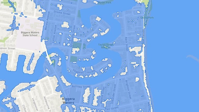
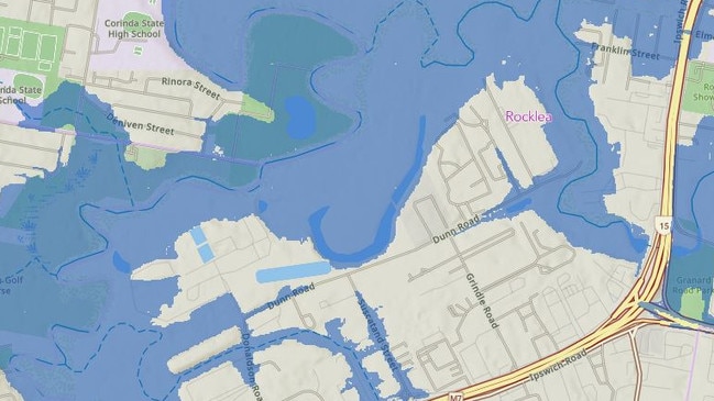
According to Brisbane City Council storm surge mapping, almost 20,000 residents could be impacted, particularly in Nudgee Beach, Brighton, Windsor, Morningside and Rocklea.
Mr Schrinner said the mapping was being updated as new information came to light.
He said residents should not be driving on the roads during the next two days.
“If you are driving on the road during gale force winds, anything could happen,” he said.
“People should not be out tomorrow and the next day, at the very least.
“I don’t want to see one single person electrocuted, I don’t want to see one single person hit by flying debris.”
Mr Crisafulli said helicopters with winch capability were on standby, along with Australian Defence Force assets.
About 1000 energy crews are ready to respond and pre-emptive emergency declarations have been put in place in key areas.
The Australian Defence Force is ready to respond, and aircraft with winches are on standby.
Rescue vessels have been sent to the Gold Coast and multiple are set up along the Brisbane River.
Schools in impact areas will be closed Thursday and Friday.
Public transport services will stop tonight. No services will run on Thursday and Friday.
Mr Crisafulli said residents also need to prepare for bridges to close once wind hits 90km/h.
After midday today, no vessel will be allowed on the water without permission from the Brisbane harbour master.
Mr Crisafulli said health services were ready to respond as necessary.
Acting Commissioner Shane Chelepy said police were continuing to doorknock residents in areas who were subject to storm surges.
He said they were asking people to ensure they had an evacuation plan in place.
“If you are given that advice to leave that area, from either our personnel, or an emergency alert that may be issued, you should to take that advice,” Mr Chelepy said.
“Whether that be today or the next coming days, those personnel and those alerts are there to keep you safe.”
Mr Chelepy said there were expectations of severe flash flooding and major riverine flooding across the southeast and urged Queenslanders to follow advice when it was given to them.
“Please heed that advice as the worst time for you to be leaving your premises is in the middle of this event,” he said.
“It puts you at risk and it puts our emergency service personnel at risk.”
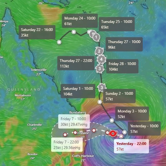
Latest tracking details
The Bureau of Meteorology said that at 10.35am on Wednesday Cyclone Alfred was a category 2 system with sustained winds near the centre of 95km/h and wind gusts to 130km/h.
It was estimated to be 335km east of Brisbane and 315km east of the Gold Coast, moving west at 16km/h.
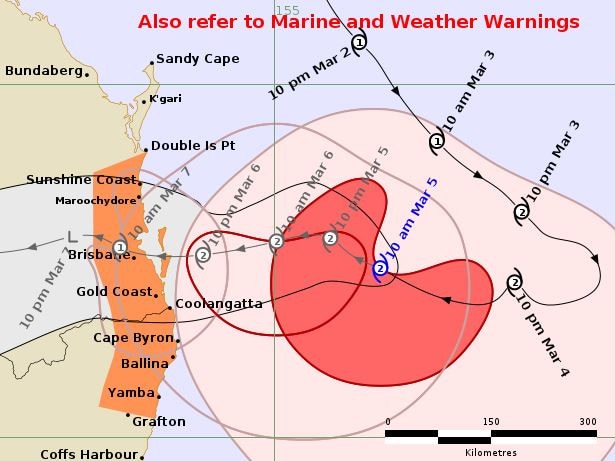
The anticipated 7am landfall time has shifted from 1am as a result of the slow speed of Alfred’s approach, meaning it would miss high tide, which would have increased the flood risk.
“The main impact will be to the tide, so the high tide is around 2am Friday morning so if it is a bit slower then that means it is not coming across in conjunction with the high tide,” Mr Narramore said.
“That means our storm surge will probably be a little bit lower.
“But we are going to have huge waves on top of that so still going to have some impact there.”
That arrival time could still change, and speaking while it was still expected at 1am, Premier David Crisafulli warned of the consequences of landfall coinciding with a high tide.
“That brings a huge layer of complexity, which is why we are saying to people, we will provide the information about what a storm surge looks like if it was to cross at that high tide, and councils will provide modelling, which will show the impact zone as a result,” he said.
“So if you are in one of those areas, and councils will map that, then you have to make a decision about what you do, and there will be assistance given, and there will be door knocking, and there’ll be information on the website.
“If you’re not in one of those zones, it’s important that you get your home ready, and that’s for the vast majority of people.”
Residents told to consider leaving
Tens of thousands of Queenslanders in low-lying areas have been urged to consider leaving their homes amid major flooding fears.
Speaking at a press conference on Wednesday morning, Mr Crisafulli said residents in the storm surge flood zones needed to make their evacuation plan now.
“If you have the option to stay with family and friends, take that option,” he said.
“If it was the case this system was to cross on high tide, in the middle of the night, and you’re in that storm surge, the last place you want to be is in your home.
“Now is the time.”
Acting Commissioner Shane Chelepy said police were continuing to doorknock residents in areas who were subject to storm surges.
He said they were asking people to ensure they had an evacuation plan in place.
“If you are given that advice to leave that area, from either our personnel, or an emergency alert that may be issued, you should to take that advice,” Mr Chelepy said.
“Whether that be today or the next coming days, those personnel and those alerts are there to keep you safe.”
Mr Chelepy said there were expectations of severe flash flooding and major riverine flooding across the southeast.
A strong police presence was seen door knocking residents of Nudgee Beach ahead of Tropical Cyclone Alfred making landfall.
Elizabeth Packer, who has lived in the area for 18 years, said police were warning residents about the storm surge.
“They’re just letting us know that the tide, when it comes up, the surge is going to be pretty high,” Ms Packer said.
“My biggest concern is probably not the water, it is the wind with the roof.”
Ms Packer said several residents in the area have decided to evacuate.
Travel updates
Gold Coast Airport will close at 4pm Wednesday with all flights cancelled. In a statement, a spokesperson said the safety of “of our team, customers and airport is our number one priority”.
Passengers affected will be contacted by their airline regarding their options to reschedule travel.
The terminal building will be closed and there will be no public access during this time.
Brisbane refuge shelter established at RNA Showgrounds
Brisbane City Council will establish a temporary refuge shelter at the RNA Showgrounds from 7am on Thursday for residents from at-risk areas who have been warned to relocate and cannot find alternative accommodation.
The shelter will be a short-term facility to protect people during the predicted peak wind period of Tropical Cyclone Alfred, and is a place of last resort.
Mr Schrinner said the refuge centre was not the same as an evacuation centre.
“This will be available to people who have no other options, it will be a very basic facility, this isn’t a facility with beds, it isn’t a facility for the long term, it’s designed to protect people’s physical safety during the most intense part of the cyclone,” Mr Schrinner said.
“As we move forward, we will also be opening evacuation centres and these are the types of centres Brisbane residents will be more familiar with.
“In the first instance, it’s about physical safety … then we will move to evacuation centres that will provide more services and a longer term option.”
The shelter will open from 7am on and will only accept residents up to 12pm.
After that time, the facility will be locked down.
If conditions deteriorate, times may change and will be communicated.
Police and Queensland Fire Department Staff and some Council staff will be present at the shelter.
The shelter will include only basic amenities and will not have beds or cooking facilities.
Residents who need to relocate are being asked to try and seek accommodation with family and friends first before considering the refuge shelter.
Meanwhile, Logan City Council said it would open an evacuation centre at the Logan Metro Sports and Events Centre on Thursday at 7am.
Council had already established temporary drop-in places of refuge at Jimboomba’s Caddies Community Centre and Bethania Community Centre.
When the heavy rain will begin
Bureau of Meteorology Senior Meteorologist Christie Johnson said as Alfred closes in, heavy rainfall is expected to begin on Thursday, with locally intense rainfall arriving later in the afternoon.
“Several hundred millimetres is possible within six hours which could lead to life threatening flash flooding. We are also expecting damaging winds to develop about the Queensland coast today and then spread further inland tonight and on Thursday,” she said.
Almost 20,000 properties in the Brisbane City Council catchment alone are set to be flooded, according to the latest modelling.
Gold Coast City Council has warned 6000 properties are in the firing line, while City of Moreton Bay Council expects multiple streets and at least 50 homes to be impacted by at least floor-level flooding.
Hundreds of police on Tuesday began doorknocking island communities and homes in low-lying areas around the Gold and Sunshine coasts, with voluntary evacuations beginning on Stradbroke Island.
Brisbane Lord mayor Adrian Schrinner on Wednesday morning told ABC Radio there will be evacuation centres established, but the exact locations have yet to be confirmed.
“We’re talking to the different locations to see which one can be activated,” he said.
“As soon as we get that locked in, we can get it set up very quickly. In 2022, we got sensors set up in a matter of hours.
“We got a number of options for evacuations that we will announce today.”
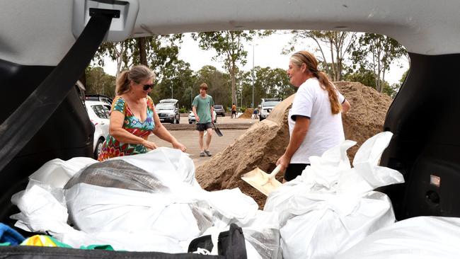
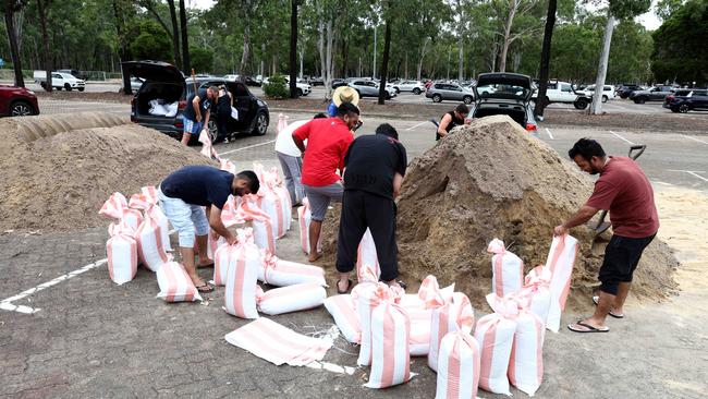
As Mr Crisafulli urged Queenslanders to be prepared, he said the government had amended regulations to allow stores to restock 24 hours a day in 21 local government areas.
“We are asking Queenslanders to stay on their guard,” he said.
“We are prepared, we are asking Queenslanders to do the same.
“It is a really rare event for southeast Queensland but it is serious and it is happening and we want Queenslanders to be prepared.”
Mr Crisafulli yesterday briefed members of parliament, from the Gold Coast to Maryborough, about the impacts of the cyclone.
It came as the Bureau of Meteorology warned tides could be 0.5m to 0.8m higher than the “highest astronomical tide”.
“Ultimately the severity of the system, when it crosses and where it crosses, are all really important factors,” Mr Crisafulli said.
“If it is to cross at high tide it makes it a far more challenging prospect. So the modelling that councils are doing at the moment is to factor in a storm surge over and above what that high tide is.
“As the system gets closer, that will be communicated and councils will lead that.”
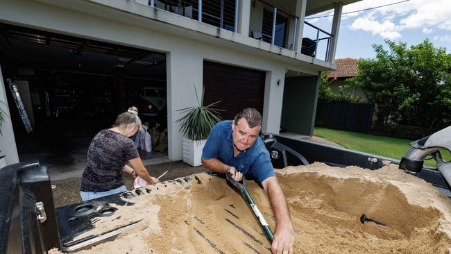
Prime Minister Anthony Albanese flew in to Brisbane on Tuesday night as the city prepares for the worst., saying the federal government will be delivering 250,000 sandbags.
He said the sandbags were requested on Tuesday but was unable to confirm when they will arrive at Brisbane.
“The other thing that we’re doing is putting the Australian Defence Force on standby, taking a range of measures, including pre-positioning heavy lift helicopters from the national aerial firefighting fleet,” he said.
“We’ve activated the Australian Government disaster response plan. We’ve been in the national co-ordination mechanism to assist with the co-ordination of the Commonwealth Government response.”

Mr Albanese warns Queenslanders to not take risks, “It is always best to hope for the best, but prepare for the worst”.
“That is all that we can do at this time, and I know that Queensland is tough and resilient, but these are tough times, and it’s going to be a tough few days,” he said.
The Prime Minister can wait no later than Monday to call an April 12 election, which has long been the favoured option to avoid delivering a federal budget this month, but a Labor source said there was not yet “serious talk” of the cyclone causing a delay in any plans to call the election this Sunday, but the situation was being “closely watched”.
Acting Commissioner Shane Chelepy said police had pre-deployed 255 officers to Sunshine Coast and Gold Coast areas to help doorknock.
Officers were also doorknocking City of Moreton Bay and Brisbane coastal areas.
Using local government’s early modelling of storm tides, emergency services doorknocked residents warning them of the risks and that they should possibly leave.
“The QPS has officers pre-deployed in a number of these areas to assist in preparations and any emergency response,” a spokesman said.

Areas most at risk of flooding
Brisbane City Council warned almost 20,000 properties could be impacted by the potential storm surge or flooding. According to new emergency flood modelling, suburbs most at risk include Brighton, Windsor, Ashgrove, Morningside, Rocklea, Coopers Plains, Carina, Sandgate, Hemmant, Lota, Tingalpa, Indooroopilly, Albion, Bardon and Wynnum West.
Police have confirmed officers will be doorknocking about 1600 homes on the Sunshine Coast that have been identified as being at high risk of flooding, based on the Sunshine Coast Council’s flood maps.
Gold Coast City Council warned that up to 6000 properties could have some form of impact from rain, and a worst-case potential storm surge of 70cm.
The council released a new disaster flood risk map showing potential flooding in scores of suburbs from Yatala in the north to Currumbin Valley in the south.
Many of the 40-plus residents of Couran Cove – who are living off-grid after water, power and sewerage was cut off last year amid a bitter body corporate dispute – are staying put as Cyclone Alfred bears down.
The council also warned residents in other low-lying areas to prepare for flooding and potential evacuations.
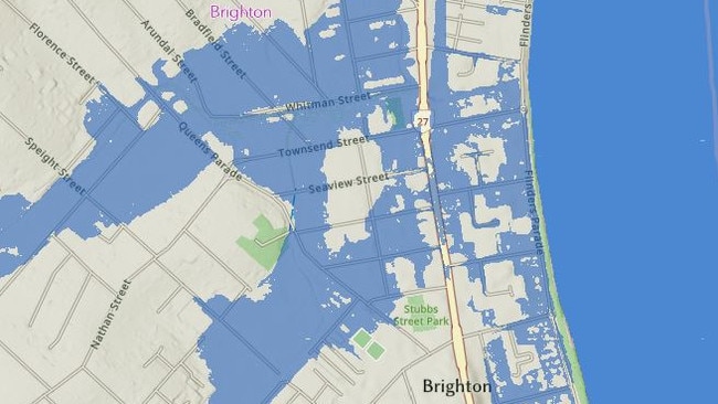
Moreton Bay City Council storm surge flood mapping showed the potential of multiple streets and areas being inundated by water, including the bridge from Brighton to Redcliffe.
About 50 homes were forecast to be impacted by potential floor-level flooding. Homes were doorknocked and residents warned of the looming danger.
Mr Crisafulli said there are more sandbags on the way to Queensland after many arrived overnight.
“Obviously, they are at the councils’ different depots, and we are helping the local government replenish those,” he said.
Opposition leader Peter Dutton said Tropical Cyclone Alfred was a “very serious weather pattern” and urged Southeast Queenslanders to prepare and act.
“People need to take all of that advice that they’re hearing, there’s only a short window of time to act and to prepare and to make sure that you put in place everything that the Premier and the Lord Mayor, and the mayors and others are advising,” Mr Dutton told 4BC Radio.
“It is certainly concerning … everyone was hoping that it might downgrade to category one, but it’s certainly a Category Two.”
Mr Dutton urged Southeast Queenslanders to not panic but to keep up to date with emergency alerts and warnings.
“I think people do need to look at the state government websites, listen to the Premier’s advice, but not be panicked about it,” he said.
Mr Crisafulli said the Port of Brisbane is now closed to freight.
The Bureau of Meteorology was working with the airport to determine if flights would be impacted.
Brisbane’s Supreme and District Courts will be closed Thursday and Friday, as will Ipswich District Court, Beenleigh District Court, Southport District Court and the Land Court.
Family owned ferry service Stradbroke Flyer Gold Cats, which runs services connecting Brisbane with the North Stradbroke Island, said on Wednesday the 11.30am boat leaving Cleveland and the noon service leaving Dunwich will be the last ones to run due to the cyclone. “After today, the boats will be closed until further notice,” a statement read.
More Coverage

Originally published as Countdown to Alfred’s impact: Power cuts, major flooding, millions told stay home

Supermarkets close as Tropical Cyclone Alfred looms large
Some major supermarkets have begun to close and won’t reopen until at least Saturday – if it is safe – as Tropical Cyclone Alfred barrels towards South East Queensland. SEE WHAT’S OPEN
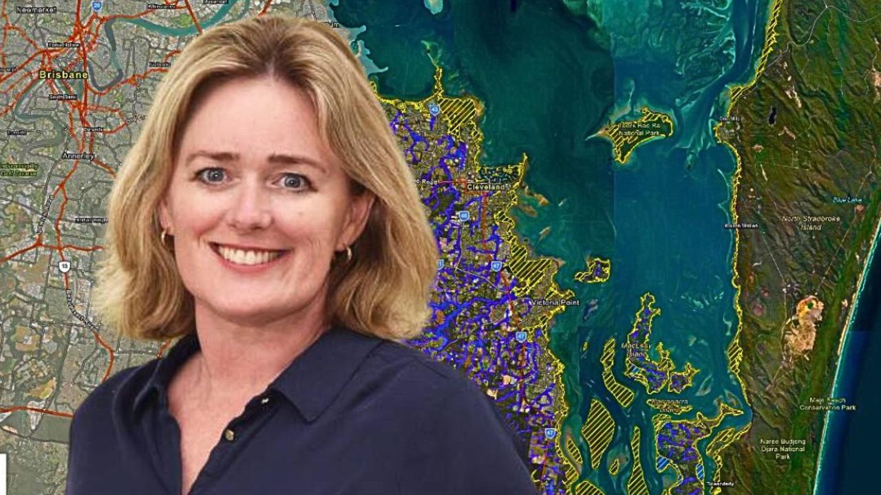
New Redland map shows thousands at risk of tidal surge, flooding
A newly updated flood risk map of Redland City reveals thousands of homes could be impacted by tidal surges and heavy flooding over the coming days.