
Redland mapping shows thousands at risk of tidal surge, flooding
A newly updated flood risk map of Redland City reveals thousands of homes could be impacted by tidal surges and heavy flooding over the coming days.

News
Don't miss out on the headlines from News. Followed categories will be added to My News.
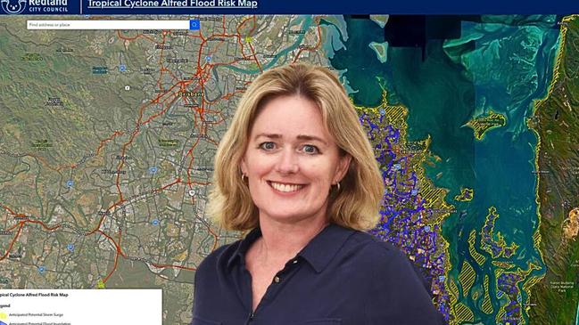
A state-of-the-art flood map of Redland City, released on Thursday, shows thousands of homes could be affected by flooding and tidal surges over the next three days.
The new map highlights approximately 8000 island and mainland properties including those around canal estates and along waterfront easements.
Redland mayor Jos Mitchell said the map was upgraded on Thursday to combine both anticipated storm surges and potential flood inundation.
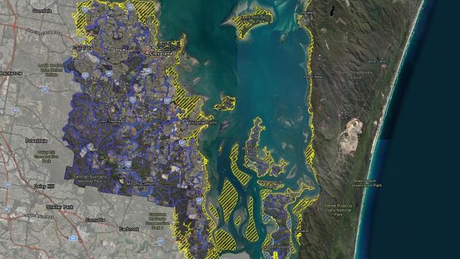
Key areas identified as vulnerable to storm surge include parts of the four southern Moreton Bay islands and low-lying coastal suburbs of the mainland.
Dozens of kilometres of Redland coastal and island regions are at the highest risk of tidal surges, with the most exposed areas including North Stradbroke Island’s eastern coastline including Main Beach, where open ocean exposure amplifies storm surge impacts.
Additionally, key mainland locations such as Cleveland, Victoria Point, and Redland Bay also fall within the council’s main storm surge zones, according to the map, with potential for coastal flooding and infrastructure damage.

Beyond coastal surge impacts, extensive flood inundation threats exist across Redland City, according to the map, which shows widespread vulnerability in low-lying parts of the mainland, particularly in Thornlands, Redland Bay, and Mount Cotton and around the Logan River.
Southern sections of the city and the islands, including Russell Island, Macleay Island, and Lamb Island, are also identified as high-risk flood zones.
The map highlights the islands and low-lying coastal areas of Redland Bay as susceptible due to both tidal influences, rainfall run-off, and proximity to riverine and mangrove systems.
While no mandatory evacuations have been announced, residents in flood-prone zones have been advised to take necessary precautions.
Emergency services have warned that rising tides, combined with heavy rainfall, could lead to hazardous conditions on the islands and on the roads.
Tidal surges, driven by strong winds and low atmospheric pressure, can push seawater inland, affecting coastal communities and disrupting transport routes.
The combination of high tides and storm activity increases flooding risk.
“It’s a map that is easy for our residents to interpret and to see what our flooding and tidal surge risks are for our local government area,” Cr Mitchell said.
“This allows our residents to have a look and see where their homes are and what risks they might face.”
More Coverage


Originally published as Redland mapping shows thousands at risk of tidal surge, flooding
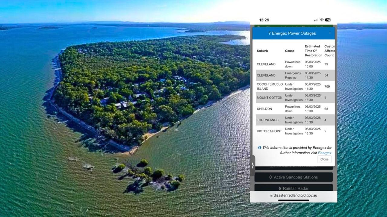
Coochiemudlo Island residents facing days without power
Hundreds across Redland City are without power, with Coochiemudlo Island worst affected and residents told it will not be restored until Monday.
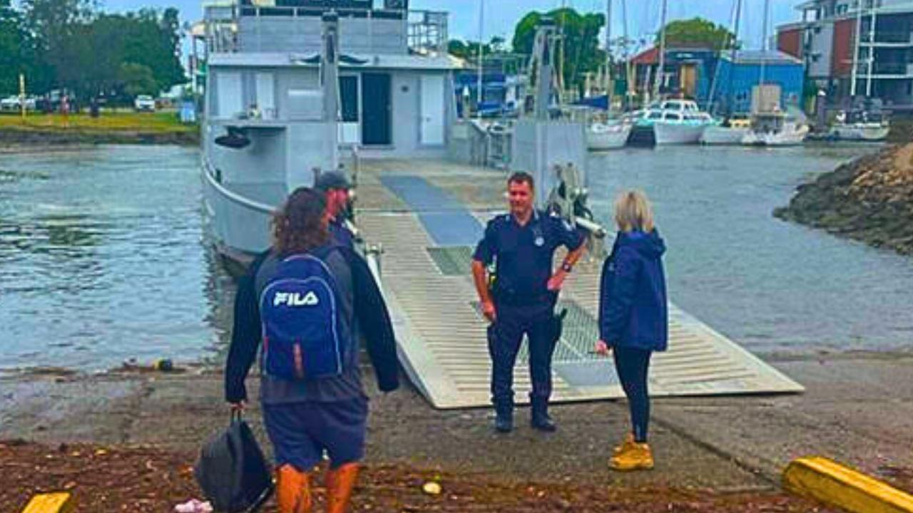
Russell Island man rescued after missing last boat
Good things come to those who wait, including for a Russell Island man stranded after he missed the last ferry home on Wednesday. WATCH THE VIDEO