
Severe weather warning for Victoria as massive rainband crosses east
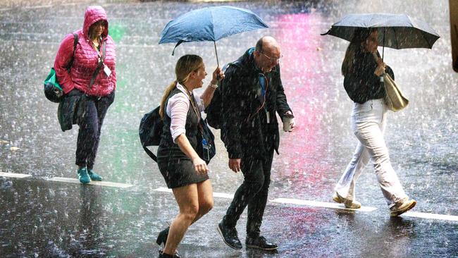
Victorians have been warned to brace for wild weather and watch for floods as a massive storm front closes in.
Weather
Don't miss out on the headlines from Weather. Followed categories will be added to My News.
Victorians have been warned to watch for potential flooding over the next couple of days, with a monster storm expected to sweep across the state from Wednesday afternoon.
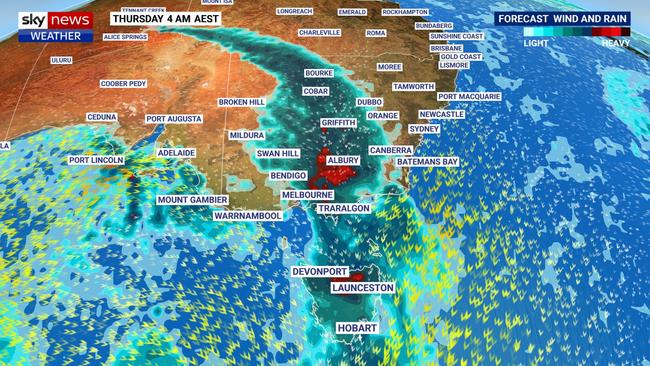
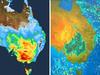
The Bureau of Meteorology and emergency services have issued a flood warning for parts of northern Victoria and the greater Melbourne area as a low pressure system is set to cross east, bringing with it heavy rain and thunderstorms.
The weather bureau said a number of catchments are likely to be affected by the heavy rainfall, including the Yarra, Maribyrnong, and Werribee rivers, as well as a number of regional systems.
“River level rises are likely in catchments within the flood watch area, where minor flooding may develop from overnight Wednesday into Thursday,” the BOM said in a statement.
“Isolated moderate flooding is also possible in areas with the heaviest rainfall.”
âš ï¸ #FloodWatch issued for parts of #Victoria. Minor and isolated moderate flooding may develop from overnight Wed in catchments listed. See https://t.co/zQk6fgvnx0 for details and updates; follow advice from @vicemergency#VicFloods@vicsesnewspic.twitter.com/r7OmZ4bztZ
— Bureau of Meteorology, Victoria (@BOM_Vic) June 6, 2023
Although some areas may only see rainfall totals up to 40mm from Wednesday night into Thursday morning, the BOM warns other parts of Victoria could see thunderstorms and downpours up to 100mm.
The showers and thunderstorms are forecast to ease into Friday.
The Victorian State Emergency Service also issued a severe weather warning for heavy rainfall and damaging winds across the state.
The weather warning comes as an eastwards-moving wet weather system smashes southern parts of Australia with heavy rain and strong winds.
South Australia was hit by more than 65,000 lightning strikes to 5am on Wednesday, according to the Bureau of Meteorology, leaving more than 10,000 homes without power in the early hours of the morning.
And Sky News Weather meteorologist Bradlyn Oaks said the wet and wild weather was only “starting to ramp up along the border with South Australia and Victoria” as a cold front from the west moves east.
“There is the potential for flash flooding, this is why we have severe weather warnings in South Australia and into Victoria,” Oakes said.
She said the heaviest falls will likely be paired with thunderstorm activity, and “pockets of heavy showers” which are more likely to fall on higher terrain.
The cold front has tracked across the country from Western Australia, where Perth recorded more than 100mm of rain in the past seven days.
The western state’s capital city copped a whopping 71.2mm of rain on Monday, alone, its heaviest single day of rain in five years. It also brought damaging wind gusts of over 100km/h to a number of weather stations in the southwest.
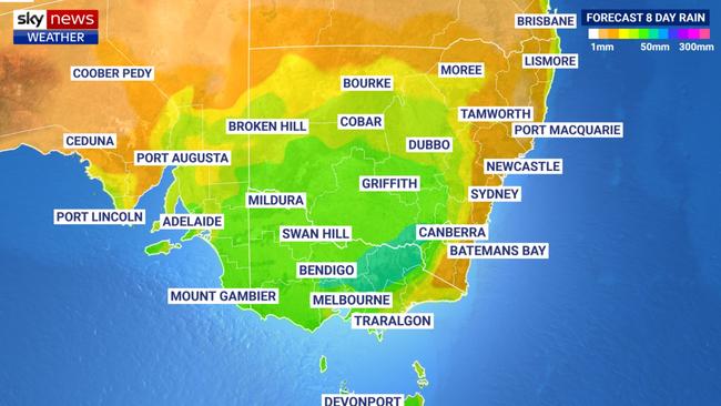
Sky News meteorologist Alison Osborne warned on Tuesday the moving system would generate a “big rainband” over South Australia, Victoria and NSW, as it tracked east this week.
Sky’s Rob Sharpe added that it would lead to a “remarkable level of rain for this time of year in the south east inland”.
How’s the weather looking in your backyard? Send us your pics – georgina.noack@news.com.au
Originally published as Severe weather warning for Victoria as massive rainband crosses east

Millions brace for brutal cold fronts
A fresh wave of wild weather is preparing to lash Australia, bringing freezing winds, thunderstorms and icy blasts to millions.

Wild weather warning for this capital city
There will be “one last sting in the tail” of the polar air blast that has marched across Australia, with wild winds to continue battering the nation.