
Deluge destroys bridge as BOM updates Cape/Gulf flood watch
Flood waters have destroyed a bridge leading to Georgetown and more rain is on the way as the national forecaster warns of abnormally high tides forecast for The Gulf and Torres Strait.

Cairns
Don't miss out on the headlines from Cairns. Followed categories will be added to My News.
A bridge has collapsed on Gulf Development Road to the west of Georgetown amid fresh flood warnings from Bureau of Meteorology across the region.
The Transport and Main Roads traffic site has said that at Routh Creek Bridge all lanes are blocked in all directions with long delays expected.
It advises that people use an alternative route.
Meanwhile in Cape York, the Peninsula Developmental Road at the notorious Archer River Bridge is also closed to all traffic in both directions with delays expected due to the river running over the road.
The wrecked bridge has cut off Georgetown and Gulf communities from Cairns and Townsville amid alerts warning of elevated river levels and flooding continuing across Cape York Peninsula and parts of The Gulf Country.

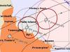
The Bureau said the monsoon trough extended across the southern Gulf of Carpentaria coast, the base of Cape York Peninsula, and into the Coral Sea and “will continue to persist for several days”.
Moderate to locally heavy rainfall has already been observed across the Flood Watch area over the last few days.
In the 24 hours to 9.00am on Sunday, rainfall totals up to about 60mm have been recorded. “Catchments are wet and rivers will respond relatively quickly to further rainfall” the Bureau said.
Showers and thunderstorms with locally heavy falls are likely to during Sunday and Monday.
Abnormally high tides are also forecast along The Gulf of Carpentaria coast and through the Torres Strait for several days, with sea levels potentially exceeding the highest tide of the year.
“River level rises are likely to continue and further riverine flooding is possible within the Flood Watch area for the next few days, particularly across western parts of the Peninsula Forecast District, as well as in isolated catchments in Eastern Cape York Peninsula, and parts of The Gulf Country” BOM said in a statement.

Widespread river level rises, isolated minor to moderate flooding, and impacts to transport routes have been observed within the Flood Watch area.
Catchments likely to be affected include
Norman River (Minor flooding occurring along the Lower Walker Creek )
Gilbert River (Minor flooding occurring at Miranda Downs Station)
Jardine River
Ducie, Jackson and Skardon Rivers
Wenlock River
Embley and Mission Rivers
Watson River
Archer and Coen Rivers
Holroyd and Kendall Rivers
Coleman and Edward Rivers
Mitchell River (Moderate flooding occurring at Kowanyama)
Staaten River
Olive and Pascoe Rivers (Flooding of roads and crossings observed)
Lockhart River (Flooding of roads and crossings observed)
Normanby River
More Coverage

Originally published as Deluge destroys bridge as BOM updates Cape/Gulf flood watch

Revealed: Former mayor cleared of misconduct claims
The Queensland Civil and Administrative Tribunal has cleared former Cairns mayor Bob Manning who faced 23 allegations of misconduct.

What to expect at 10th Cairns Ecofiesta
From DIY stingrays and electric vehicle displays to gardening workshops and plant giveaways, there will be something for everyone at the 10th annual Cairns Ecofiesta. See what’s on.