
Severe weather: Murrumbidgee farmers brace for wipe out
Major flooding along the Murrumbidgee is expected to wipe out up to 80 per cent of low lying crop.

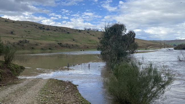
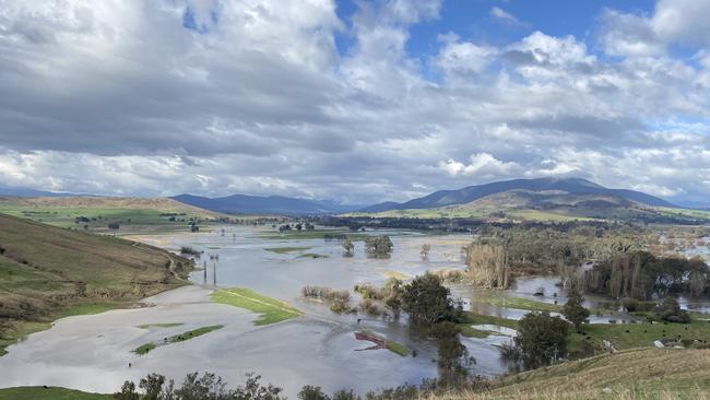
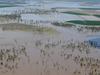
Farmers along the Murrumbidgee river are bracing for major flooding that is expected to wipe out up to 80 per cent of low lying crops over the weekend.
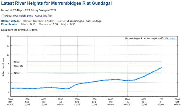
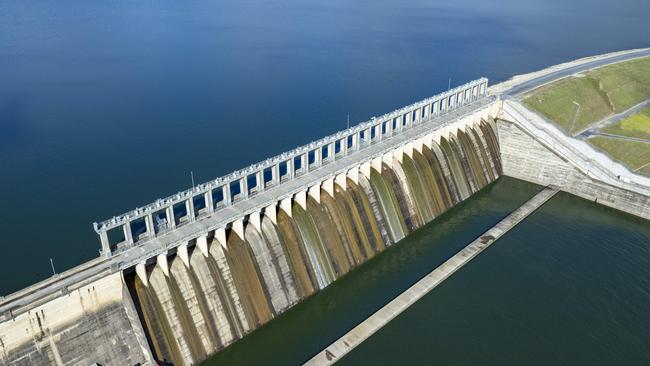
At 4pm on Friday state water authorities were expecting 100,000ML of water to spill from Burrunjuck Dam, with river heights at Gundagai and Wagga Wagga expected to reach over 9m.
Bureau of Meteorology river height data shows the Murrumbidgee River rose more than two metres in the 24 hours to 12pm Friday, with more rises expected over the weekend.
Riverina Independent Agronomy owner and agronomist Neil Durning said he was expecting to lose 100 per cent of the wheat and canola crops on his property near Wagga Wagga if the Murrumbidgee reached 9m as expected.
“We only had 15mm here so it is quite surreal. The sun is shining and you’re not that wet but you’re trying to prepare to get wiped out,” he said.
Mr Durning, who manages wheat and canola for clients along the Murrumbidgee River, said he expected farmers downstream from him to lose 70 to 80 per cent of crops if the river reached 9m.
“Nine metres does a fair bit of damage. It will wipe out a lot of crop.
“There’s not much low river country that is protected from a nine metre river,” he said.
“But there’s not much you can do about it. You choose to live on a floodplain and you choose to put crops in the ground knowing this could happen.”
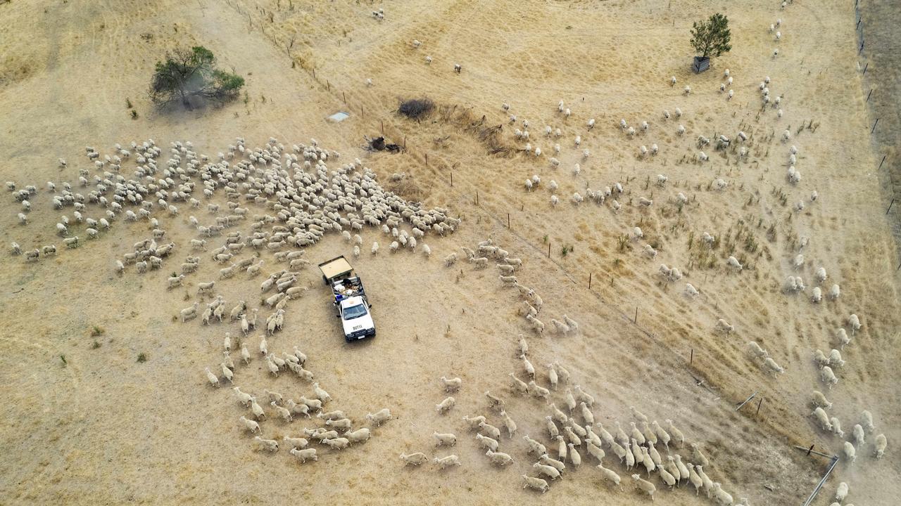
Gundagai Elders branch manager and head of Gundagai SES Ross Tout said several hundred cattle were still in low lying areas around Gundagai but he was not concerned for their welfare unless the river reached a height above 10m.
Mr Tout said warnings had been issued to property owners downstream of Gundagai, who he expected to have enough time to move livestock out of the path of rising waters.
The last time the Murrumbidgee River reached similar flood levels was in 2012, when the river peaked at 10.92m at Gundagai. In 2016 the river peaked at 8.5m.
Further north, Hart Bros Seeds agronomist Robert Hart said there would be a lot of lost crops in the Bland area around West Wyalong as a result of this week’s heavy rain.
“There quite a bit of crop that is either destroyed or that is now an absolute certainty that it won’t be able to be planted,” Mr Hart said.
“There are really big area out there that is very wet and doesn’t have the ability to drain or dry off quickly.”
West Wyalong recorded 39mm of rain this week.
11AM FRIDAY 5 AUGUST
Storms in southern NSW have led to flash flooding, with the Bureau of Meteorology issuing flood warnings for a number of areas.
Mixed farmer Paul Nugent from Biggara, who farms Angus cows and feed canola, said a portion of his property was underwater after a small creek swelled during heavy rain.
Mr Nugent said he was yet to assess the damage but the flooding appeared to be less severe than 2021 floods.
“We’ve got a bit of country underwater. There will be a few fences down and a few things to fix, but that comes with the country,” Mr Nugent said.
A nearby weather station at Khancoban recorded 18.4mm overnight and 55.8mm for the week.
Further up the mountains, Perisher Valley recorded 156mm for the week and Thredbo 114mm for the week.
Downstream on the Murray, Jingellic recorded 18.8mm overnight and 56mm for the week.
Further north, Cootamundra recorded 27mm overnight and Cobar 24mm, with widespread totals of over 20mm across much of central and southern NSW.
The Bureau of Meteorology has warned moderate flooding is occurring at Biggara and Bringenbrong, with minor flooding likely at Jingellic.
Moderate flooding is also expected at Bathurst and Canowindra on Friday.
12PM THURSDAY 4 AUGUST
Parts of north east Victoria and south east NSW recorded more than 50mm of rain overnight.
Falls Creek, between Bright and Omeo, recorded falls of 55mm, while rain gauges at Thredbo and Perisher in NSW recorded 64mm.
Minor to major flood warnings are in place for the Upper Murray and Mitta Mitta Rivers,
Kiewa River, Ovens and King Rivers, and the Seven and Castle Creeks.
Six-hourly rainfall totals of 15 to 40mm are expected with localised totals of 40 to 60mm possible over the far northeast ranges near the NSW border on Thursday.
Rain recorded overnight has fallen on areas with already saturated soils. Agriculture Victoria reported last week soil moisture probes at Rutherglen and Greta in the state’s north east measured 100 per cent, while a probe at Strathbogie measured 95 per cent soil moisture.
4PM WEDNESDAY 3 AUGUST
Northeast Victoria has been warned to brace for thunderstorms and possible flooding on Thursday.
The Bureau of Meteorology has forecast heavy rainfall with six-hourly totals of 15-40mm across Victoria during Thursday morning, with some localised totals up to 60mm.
Thunderstorm activity is expected to increase during Thursday, possibly severe in the northeast on Wednesday afternoon and again on Thursday.
A minor flood warning is current for Seven and Castle creeks and a flood watch for minor to moderate flooding has been issued for northeast Victoria.
Damaging winds averaging 60 to 70km/h, peaks up to 100km/hr will ease on Wednesday afternoon, and may redevelop over Alpine peaks on Thursday.
12PM WEDNESDAY 3 AUGUST
Thousands of people in Victoria’s east and southwest are facing power outages on Wednesday after high winds downed trees and damaged buildings.
Affected towns include Cockatoo, Gembrook, Warburton, Avonsleigh, Inverloch, Emerald, Silvan, Macclesfield, Mout Evelyn, and Monbulk.
In the state’s southwest, hundreds of customers in Lorne, Camperdown and Horsham were without power on Wednesday.
State Emergency Services responded to 411 requests for assistance over the past 24 hours.
The majority of call-outs were for fallen trees, while 31 callers requested help for building damage.
Energy Safe Victoria issued a warning for people to stay more than eight metres away from fallen powerlines and to always treat fallen powerlines as live.
Meanwhile rainfall across the state has added moisture to already saturated soils.
South of Albury, Mount Buffalo Chalet recorded 40mm overnight, Handcocks 38mm and Charnwood 31mm. Lal Lal, east of Ballarat, recorded 35mm.
TUESDAY 2 AUGUST
Flood warnings and watches have been issued for northeast Victoria this week as rain and snow melt potentially combine to swell rivers.
Predictions of up to 100 millimetres for the alpine areas have forced the Bureau of Meteorology to issue the flood warnings and the warmer temperatures mean that rain will not fall as snow and could actually melt what snow was there, adding to inflows.
BOM duty forecaster Miriam Bradbury said the next few days would be “pretty wet in the north east”.
“It is likely we will see flood warnings for most if not all of the northeast catchments but there is an outside risk of a major flood warning in the Upper Murray,” Ms Bradbury said.
The forecasts will be a challenge for dam managers with Hume Dam sitting at 92 per cent and Dartmouth Dam at 96 per cent on Tuesday.
Murray Darling Basin Authority river management executive director Andrew Reynolds said they had been releasing water from the Hume Dam since May and had 250 gigalitres in air space.
“This will significantly mitigate the impact of the rain event, however depending on the volume of rain and the inflows that result, there is a chance that releases may need to be increased,” Mr Reynolds said.
“River operators continue to work around the clock to assess new inflow and weather information and manage releases accordingly.”
The wet forecast followed a dry July across large parts of Victoria with most centres failing to hit their long-term monthly average and some places struggling to record even a quarter of their normal totals.
Mildura, in the heart of Victoria’s Mallee region, recorded just 4.6mm for the month or 18 per cent of its long-term July average. Yarrawonga in northern Victoria picked up just 12.2mm for the month, or 27 per cent of its average, while Swan Hill measured 9.4mm (34 per cent), Wangaratta 24.2mm (37 per cent), Shepparton 19.2mm (45 per cent), Echuca 18.8mm (46 per cent) and Ararat 31mm (49 per cent). Sale just scraped over the 50 per cent mark with 21.4mm (53 per cent) as did Bairnsdale with 25mm (53 per cent) and Lake Eildon with 50.8mm (54 per cent).
Among the best-performing centres during July were Geelong which recorded 48.8mm for the month, or 129 per cent of its annual average, Nhill (30mm or 89 per cent), Mortlake (55mm or 88 per cent), Bendigo (41.8mm or 77 per cent) and Portland (82.4mm or 76 per cent).

Join the conversation
Inside farmers’ struggles as they battle the dry and high costs
A tough season and escalating expenses are making it difficult for many farmers as they prepare to sow winter crops with minimal soil moisture.
Read more
Rain smashes north, leaves southern farmers dry
More than 500mm of rain has fallen in Queensland but areas dealing with drought in Victoria and SA have had dry rain gauges.
Read more