
NSW, Vic towns on flood watch
Communities across NSW and Victoria are on flood watch after heavy rain and storms lashed the east coast over the weekend.

Communities across NSW and Victoria are on flood watch after heavy rain and storms lashed the east coast over the weekend.
In NSW, emergency services issued warnings for low-lying areas in Dubbo, Wagga Wagga and the Central Coast and flood warnings for inland rivers including the Macquarie, Darling, Bogan, Lachlan and Murrumbidgee.
In Victoria, flood warnings have been issued for the Murray, Edward, Avoc, Loddon, Barwon, Campaspe, Goulburn, Kiewa, Kin, Snowy, Yarra, and Werribee rivers.
Since 6pm on Friday, State Emergency Services in NSW responded to more than 1000 calls for help.
NSW SES assistant commissioner Sean Kearns urged communities in the path of floods to be alert.
“The water that has fallen over the last month is still travelling through our river systems and as the water travels downstream we have an increased risk of flooding in those areas,” he said.
NSW Farmers President Xavier Martin urged livestock owners to call for help if they needed it with more rainfall and flooding expected this week.
For assistance with livestock in NSW, call the NSW Government Agriculture and Animal Services Functional Area (AASFA) hotline – 1800 814 647
Updated. Roads are gone. Never seen it this big and neither had the fences. We heard them “pinging†as the wire gave way pic.twitter.com/egABQyX9UO
— Annalara White Dorpers (@AnnalaraWD) October 8, 2022
OCTOBER 7 12pm: NSW Riverina, NE Vic brace for storms
The NSW Riverina and north east Victoria are bracing for storms and flash flooding on Friday, with high rain totals already recorded and more rain on the way.
The Riverina town of Coleambally recorded 49mm in the 24 hours to 11am Friday. Hay recorded 37mm of rain in the five hours to 9am Friday morning.
The Bureau of Meteorology has warned residents in the Riverina and north east Victoria to prepare for potential thunderstorms and flash flooding as the weather systems move east.
The news comes two months after Burrinjuck Dam spilt in August, inundating low-lying crops on the Murrumbidgee River downstream of Wagga Wagga.
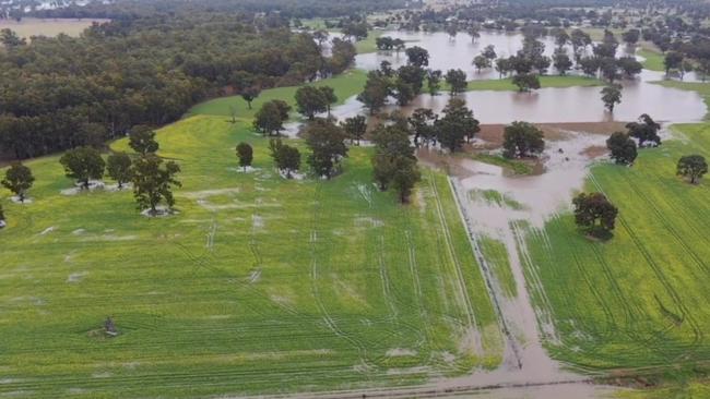
Both Burrinjuck and Blowering Dams, which feed into the Murrumbidgee River, were at 98 per cent capacity and rising on Friday.
The Murrumbidgee River has been primed for flooding since the August flood, which has slowly made its way down the river to Hay and Balranald.
Farmers have warned ongoing minor flooding on the lower Murrumbidgee could worsen any subsequent flood event as high river levels would be maintained in the river for longer.
WaterNSW has been releasing water from Burrinjuck Dam since August in an effort to mitigate potential flooding and a flood watch warning is in place for the Murrumbidgee and Tumut Rivers.
North east Victoria had recorded widespread totals of 10-20mm in the 24 hours to 11am Friday, with storms forecast for the afternoon.
OCTOBER 6 4pm: Severe thunderstorm warning for the Mallee
Severe thunderstorms are expected to hit the Mallee overnight, with heavy rainfall, hail, and damaging wind gusts possible.
The Bureau of Meteorology issued the advice this afternoon ahead of storms predicted for this evening.
Victorian State Emergency Services have warned the heavy rainfall could lead to flash flooding in Rainbow, Warracknabeal, Horsham and Stawell.
Soils in parts of the Mallee are already saturated after widespread falls of 10mm to 20mm on Wednesday. The weather station in Mildura recorded 51mm in September, double its long term average rainfall.
Tad Wet in the Mallee, still flowing strong after the rain stopped 12 hours ago pic.twitter.com/o8mu9o4NgO
— Kurt Wight (@Kurtwight39) October 5, 2022
Areas of major flooding are possible in the north east Victoria on Friday afternoon.
Minor flood warnings are in place for the Murray, Edward Rivers, Kiewa, Loddon and Snowy Rivers.
Widespread showers are forecast across Victoria on Thursday. On Friday, a second rain front is expected to bring more rain, with the heaviest falls expected in the north east.
OCTOBER 6: Challenging harvest ahead after storms
Wheat and barley crops in the Wimmera have been knocked down in Wednesday’s wet and windy conditions.
Kaniva-based agronomist Josh Merrett said compass barley, hammer wheat, and some canola had been knocked down on Wednesday but could likely still be harvested.
“It’s going to be a pain to harvest but it shouldn’t affect it too much,” he said.
Overall, crops in the region were looking “pretty good” and had yield potential of five to six tonnes per hectare for wheat and barley and three to 3.5 tonnes per hectare for canola.
Some of the lentils in the region were getting “wet feet”, which could affect yields.
“We probably don’t want any more (rain),” Mr Merrett said.
Compass Barley doing Compass Barley things. The 2022 harvest season is looking like it’s going to be a challenge @agspecaustraliapic.twitter.com/bitIRp2wQq
— Josh Merrett (@josh_merrett87) October 5, 2022
Kaniva recorded 12mm in the 24 hours to 12pm Thursday.
The nearby weather station at Nhill recorded 80mm of rain for September, more than double its long-term average for the month of 33mm.
The Wimmera wasn’t the only region struggling with lodged crops this week.
Lower Eyre Peninsula farmer Dan Adams shared a post to Twitter of knocked-over hindmarsh barley after wet and windy conditions this week.
Barley’s looking a bit flat. And yes it had a PGR pic.twitter.com/FhwSnwPMMk
— Dan Adams (@danads243) October 4, 2022
Across Victoria, heavy rain fell in central and north east regions overnight, with Bendigo recording 31mm, Broadford 35mm and Charnwood 31mm.
The Wimmera, Mallee, north and central Victoria recorded widespread falls of 10-20mm in the 24 hours to 12pm.
OCTOBER 5: Frantic start to rice 2023 season ahead of storms
Rice growers in the NSW Riverina have been pulling all nighters in the rush to get their crops in the ground ahead of forecast storms.
Murrami rice grower and newly announced president of the Rice Growers Association Peter Hermann barely slept on Tuesday night in a last-minute push to drill sow his 80ha rice crop.
“We had rain forecast at 7am and we wanted to get it in the ground before that,” Mr Hermann said.
The Bureau of Meteorology has forecast widespread heavy rain for NSW and northern Victoria for the three days to Saturday, with falls of 50mm to 150mm possible across much of the state.
The frantic start to the season may be a sign of what is to come, with multiple weather-related interruptions to planting programs and inaccessible paddocks likely due to storms and flooding.

BOM meteorologist Dean Narramore said “heavy and persistent rainfall” would move quickly eastwards across NSW and northern Victoria on Wednesday night, followed by a second weather system on Thursday and Friday and a third round of rain on Saturday.
Widespread flooding is expected across western NSW, with inundation of homes and property likely, Mr Narramore said.
Minor to major flood warnings are in place for the Murray, Murrumbidgee, Edward, Macquarie, Namoi, Bogan, Lachlan, Culgoa, Birrie, Bokhara, Warrego, Paroo, Barwon, Darling, and Macintyre rivers in NSW.
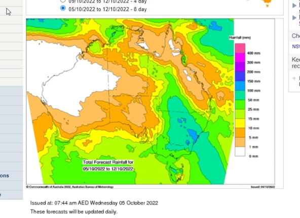
Minor flood warnings are in place for the Kiewa, Loddon and Snowy Rivers in Victoria.
North western Victoria copped a drenching in the 24 hours to 9am Wednesday with falls of 27mm recorded at Werrimull, 24mm at Walpeyup and 17mm recorded at Mildura.
Some hay growers in the Mallee have decided not to harvest their vetch crops this year as the risk of weather damage is high, while others have their fingers crossed for a dry two week break to allow crops to cure.
The spring rain is a boon for grain crops in the Mallee, which are expected to reach bumper yields.


Weather wrap: Where the rain fell
Longed for follow up rain has graced some areas but left others untouched across south-eastern Australia as the failed autumn break continues to take its toll on farmers.
Read more
‘It’s certainly been morale boosting’: Rain brings change of fortunes
Kate Paterson has tipped 30mm from her rain gauge, bringing an end to a long dry period at Nulla Vale.
Read more