
El Nino risk upgraded to alert level
The chance of El Nino developing this winter is now “very likely” according to an updated forecast.
The Bureau of Meteorology upgraded its El Nino warning from “watch” to “alert” on Tuesday, as experts warn a warm, dry winter and spring will bring lower crop yields.
In an update on Tuesday afternoon, the agency said there was now a 70 per cent chance of El Nino developing, up from its previous 50 per cent estimate.
Bureau of Meteorology senior climatologist Catherine Ganter said models showed it was “very likely the tropical Pacific Ocean temperatures will reach El Nino levels during winter”.
El Nino occurs on average every three to five years in Australia. The weather pattern brings with it an increased likelihood of reduced rainfall in eastern Australia, warmer temperatures and an increased risk of extreme heat.
The Australian Bureau of Agricultural and Resource Economics and Sciences said on Tuesday Australian wheat, barley and canola crop yields would drop by a third compared to last season due to the forecast dry conditions.
Victorian Farmers Federation president Emma Germano called on policy makers to prepare to support the industry.
“We’ve just gone through horrific floods that exposed some gaping holes in the support government provides to farmers and regional communities. Decision makers need to use past experiences to plan for the future,” she said in a statement.
“For drier times, that means prioritising drought preparedness, sustainability, resilience and risk management for farming businesses and communities well ahead of when drought strikes.”
TUESDAY, JUNE 6, 3pm
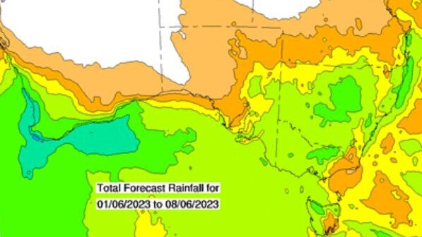
Widespread rain across southeast Australia seems to have defied predictions of a drier-than-average winter — for now.
Large tracts of Victoria, southern NSW and South Australia’s South East are forecast to receive some of the best early winter rain totals for years this week as a large rainband stretches across the south of the continent.
In rainfall measured on Monday, some of the best falls included Mildura with 14mm and Rutherglen with 16mm while centres like Bendigo, Birchip and Horsham all recorded welcome falls.
More rain is predicted throughout the remainder of the week, with more than 50mm expected in some regions.
Agriculture Victoria seasonal risk agronomist Dale Boyd said weather predictions were just that — predictions — and while forecasts still have a drier-than-average El Nino phenomenon on the horizon, high subsoil moisture levels could see crops through with limited rain should it fall at the right time.
“We are now on track for average crops even with the absence of substantial rainfall, as there is a full soil profile,” Mr Boyd said.
“Ideally, a rain in late winter or early spring would top things off and we still need this but thanks to the subsoil moisture, and this early rain will join up the soil moisture and the crops can dip into this later on.
“That’s especially true in the Mallee which is an area which has held its soil moisture really well and to quite deep levels.”
Mr Boyd said widespread rain late last month had germinated early crops, with many “up and away”, which meant follow-up falls were perfectly timed. This week’s forecast rain also prompted a rush from farmers on to tractors over the weekend, despite the likelihood of yield penalties from a later-than-optimum planting.
The rain been a balm to those watching the seemingly never-ending predictions of dry conditions and an incoming El Nino with the Bureau of Meteorology, even as late as last week, doubling down on its predictions of a drier-than-average winter.
BOM extended prediction technical lead Catherine Ganter said there was a high chance of below-average rainfall, particularly in southern areas of Australia.
‘Southern areas have at least twice the normal chance of winter rainfall falling in the bottom 20 per cent of records,’ Ms Ganter said.
She said with drier conditions forecast, the risk of frost during winter was heightened for inland southern areas.
‘Even though average minimum and maximum temperatures are expected to be warmer than usual this winter, there will still be times of cold wintry conditions,” Ms Ganter said.
“This can increase the frost risk when there are still nights that are clear of cloud cover.”
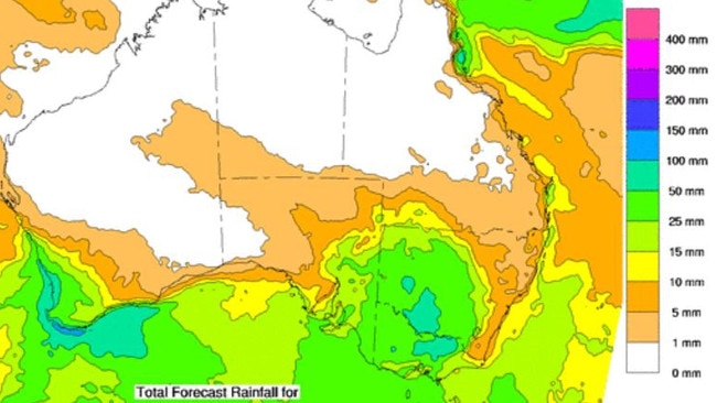
FRIDAY, JUNE 2: Hopes have been raised further about widespread rain in the next week
with the latest forecasts of up to 50mm across a large area of southeast Australia.
The Bureau of Meteorology eight-day outlook, should it be correct, could set up croppers and livestock producers for weeks.
And while spring rain will still be needed to finish crops and grow pastures, subsoil moisture levels will be boosted by the early winter rain.
The predictions are especially welcome for key cropping areas including the Wimmera and Mallee in Victoria as well as across much of the Riverina and central NSW, areas which had missed out on late autumn falls.
THURSDAY, JUNE 1:
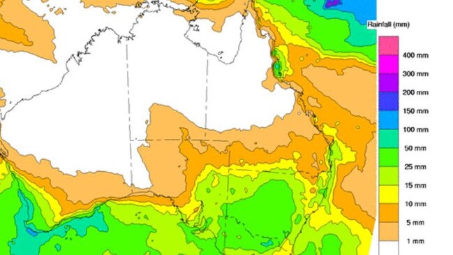
Farmers are pinning their hopes on early winter rain with predictions of healthy falls next week.
The Bureau of Meteorology eight-day outlook released today could see large areas of Victoria and NSW receiving 15-25mm over the next week, and some areas 25-50mm.
The rain would be considered perfect for those who have sown dry, as well as topping up soil moisture levels for crops already in the ground.
The predictions should also put some confidence back into agriculture given the fears an El Nino weather event is emerging, and that rainfall will be in the lowest 20 per cent of all years.
It is not just the BOM that believes rain is on the way, with several other weather forecasters predicting falls.
Elders Weather predicts there is a 90 per cent chance of 5-10mm on each of two days next week for Horsham, an 80-90 per cent chance of 5-10mm and 10-20mm for Bendigo, and a 90 per cent chance of 1-5mm and 5-10mm for Wangaratta. It predicts no rain for East Gippsland.
The news is mixed from the Norwegian weather forecaster yr.no, favoured by many producers given its 10-day predictions.
The big winner in these forecasts is Victoria’s North East, which yr.no predicts will receive close to 50mm late next week.
It also has Bendigo down for more than 25mm and Horsham close to 20mm on Thursday and Friday.
Meanwhile autumn has been largely kind to Victoria with much of the state receiving average rainfall.
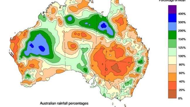
As winter kicks off today, final totals for March to May have been released and show a large slab of Victoria had a normal season.
There were exceptions. The Mallee only recorded 60-80 per cent of its average while parts of southwest Victoria and eastern Victoria had above average falls.


Join the conversation

Rain brings relief, but wild weather makes lambing tough
Showers brought some relief this week, but farmers say conditions remain challenging, with below-average rainfall, cold temperatures and wild winds hitting lambing season. See where the rain fell.
Read more

Weather wrap: Where the rain fell
Longed for follow up rain has graced some areas but left others untouched across south-eastern Australia as the failed autumn break continues to take its toll on farmers.
Read more