
NSW rushes water plan rollout: mistakes wheat paddocks as wetlands
The rush to rollout seven major water sharing plans is leading the NSW government to mistakenly identify wetlands on farms.
The NSW government’s rush to finalise seven major water sharing plans by July 1 has led it to declare channels in the middle of wheat paddocks as wetlands.
Rather than sending staff out to check on whether a wetland exists, the government has relied on maps and desktop studies to declare they exist, then put the onus on landholders to prove otherwise by February 2.
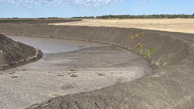
NSW Irrigators Council chairman and Gwydir farmer Jim Cush was stunned to discover Department Climate Change, Energy, the Environment and Water bureaucrats had declared a channel in the middle of his wheat paddock a wetland.
“Fifty years ago it was a gully, into which we pumped water from the river and captured tail water,” Mr Cush said. “(But) over time it’s silted up and now it’s a licensed channel on the farm.”
He said the government had even declared a depression in the middle of a neighbour’s wheat paddock, which occasionally filled up with water after heavy rain, as a wetland.
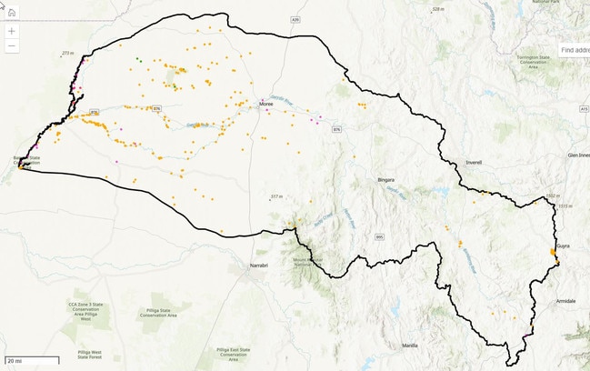
In the Gwydir Valley alone NSW DCCEEW staff identified 307 wetlands, with hundreds more mapped out in the other water sharing plans it is trying to finalise for the Barwon-Darling, Lachlan, Belubula, Macquarie-Wambuul-Bogan, Murrumbidgee and Namoi-Peel by July.
The department has said “due to the time constraints to undertake the work we were not able to do any on ground checking for the NSW specific sources as part of this process.
“We became aware that the data sets varied in quality and in some cases additional analysis would be required (and) the department is taking on board the feedback we continue to receive.
NSW Irrigators chief executive Claire Miller said “it’s as if the Department took to the valley maps with a crayon, scribbling wetlands all over them without actually visiting the regions or engaging meaningfully with those on the ground”.
“Many of the ‘significant’ wetland sites identified are in fact prime agricultural land being used to grow food and fibre, but it has been left up to farmers to prove it by 2 February.
Once the plans are finalised irrigators face restrictions on any on-farm water supply works, if they live within 3kms of any RAMSAR-listed wetland.
Mr Cush said NSWIC was concerned that restriction would be extended under future reviews to the plans to other wetlands, affecting irrigators abilities to not only modify and upgrade works, but even install new pumps.
Ms Miller said irrigators were “asking the NSW Government to postpone gazetting wetlands in water sharing plans for at least three years to enable the Department to correct mapping errors and partner with willing landholders to identify and voluntarily protect genuine wetlands on private property.
“With more than 93 per cent of wetlands in the Murray-Darling Basin being on private property, it is essential for governments to work with landholders rather than imposing regulations from above, based on inaccurate remote mapping.”


Canadian pension fund water sell-off
PSP Investments has sold $21.5 million of its Australian water entitlements to the federal government.
Water released from Menindee Lakes to service Murray River system
Inflows into major storage dams have been below average for months on end. We reveal which dams have been hardest hit and the implications.