
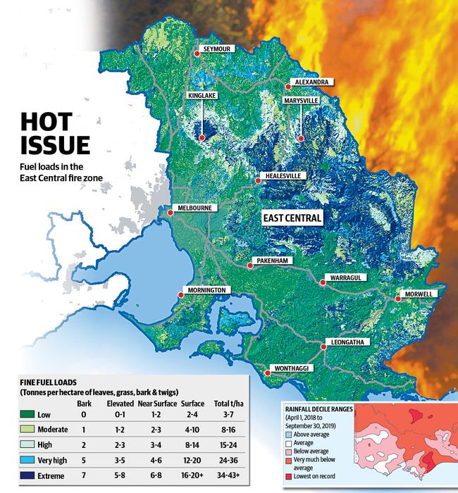
Fuel loads hit new extreme across Australia’s highest fire-risk zone
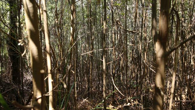
A massive build-up of highly combustible leaves, grass, bark and twigs has put thousands of Victorians at risk this summer.
EXCLUSIVE: FUEL loads in the nation’s highest-risk bushfire zone — where Black Saturday raged in 2009 — have reached extreme levels, according to the Victorian Government’s own hazard map, making suppression almost impossible and putting thousands of Victorians’ lives at risk.
An extreme rating means at least 34 tonnes per hectare of fine fuels have built up in the forests of Victoria’s East Central fire zone, stretching from Kilmore to Morwell and covering 59 per cent of Victoria’s population.
Those fine fuels stand ready to explode into flame during a catastrophic bushfire, creating massive quantities of burning bark and embers that researchers have found can spot new fires up to 35km away.
DELWP HIGH-RESOLUTION FUEL LOADS MAP (PDF)
The high-risk fine fuel loads have accumulated in the rapidly drying eucalypt forests north of Kinglake and Healesville, where in February 2009 the Kilmore East and Murrindindi fires merged to burn out 169,542ha, killing 119 people and destroying 1242 homes.
“Fine fuels are the fuels that burn in the continuous flaming zone at the fire’s edge,” according to the Overall Fuel Hazard Assessment Guide, written by Francis Hines, Kevin Tolhurst and other bushfire experts in 2010 following the Black Saturday fires.
“They (fine fuels) contribute the most to the fire’s rate of spread and flame height. Typically, they are dead plant material, such as leaves, grass, bark and twigs thinner than 6mm thick, and live plant material thinner than 3mm thick.”
HAVE YOUR SAY: Should the Government reveal the fire risk? Comment below
The Department of Environment, Land, Water and Planning has spent months trying to block The Weekly Times’ access to fuel load maps, repeatedly refusing to release data.
In August last year DELWP staff stated: “The fuel load data is only published to Business Level Data (an internal system)”.
After repeated delays, emails and calls DELWP came back almost 12 months later stating “this information is not something that DELWP typically provides and the department has some concerns with this information being made publicly accessible”.
Ultimately The Weekly Times lodged a Freedom of Information request for five years of data for the whole state, but cut back the request to one map after DELWP demanded $1294.80 to process the request.
DELWP FOI DECISION LETTER SENT TO PETER HUNT (PDF)
The 2009 Victorian Bushfires Royal Commission’s recommended that the department “specify the characteristics of fire management zones — including burn size, percentage area burnt within the prescribed burn, and residual fuel loading”.
But as it stands DELWP’s Forest Fire Management Victoria division publishes data only on residual risk, which is derived from a computer model, which gives no detail on fuel loads, which were used in the past.
Opposition emergency services spokesman Brad Battin said the Andrews Government’s “attempt to hide information that has a direct impact on community safety” should concern all who live in high fire-danger areas.
“The only reason the Victorian Labor Government would hide this important data is they have failed to meet their targets to protect Victoria this fire season,” Mr Battin said.
“With levels of fuel at extreme, a predicted dry and hot summer and a reduction in volunteer firefighters we can only say not only has (Premier) Daniel Andrews made you less safe, he now will do anything to hide the truth from you.”
In 2010 the Black Saturday Royal Commission recommended the “state fund and commit to implementing a long-term program of prescribed burning based on an annual rolling target of 5 per cent minimum of public land”, equal to 385,000ha annually. But the Andrews Government abandoned hectare-based targets in 2015, opting for a computer modelled measure of residual risk — the simulated difference between impacts of a fire with maximum fuel loads versus one with reduced fuel loads resulting from controlled burns and past wildfires.
OPINION, ED GANNON: FUEL LOAD SECRECY MUST STOP
Environment Minister Lily D’Ambrosio said the Government was using a risk-reduction target to focus its fuel-management strategies on areas that would have the greatest impact. “Using this target does not necessarily mean we are burning less, or burning more — it means we are burning smarter.”
The model has been roundly condemned by Australia’s leading bushfire scientists.
The Weekly Times has previously reported the former head of CSIRO’s bushfire research unit Phil Cheney has branded residual risk a “load of bulls---”, arguing “fuel load is the only thing that matters”.
Join the conversation
‘No one knew it was coming’: Tongala cow abattoir shuts
The livestock industry and local community have reacted to Greenham’s closure of its Tongala cow processing plant.
Read more

Victorians want to feel guilt-free about eating meat
Research – to guide a Victorian Government-funded pro-agriculture campaign – has revealed how consumers feel about the state’s farmers and what issues need to be addressed.
Read more