
Qld weather: Fresh flood threat as NQ slammed with almighty drenching
Premier David Crisafulli has sent a powerful message to NQ with cyclonic rainfall levels triggering evacuations, an airport closure while a crocodile has been spotted in flood waters.
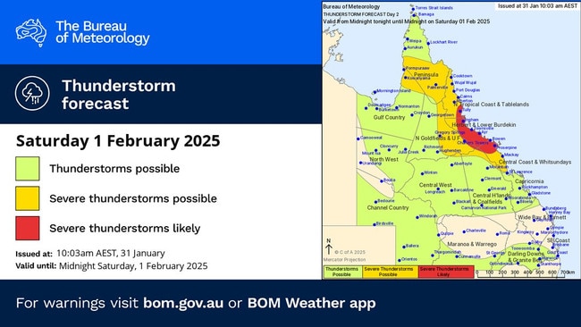
The Bureau of Meteorology has warned North Queensland residents to expect “cyclonic levels” of rainfall in coming days with isolated totals of 600mm possible.
The warning came from the bureau’s senior forecaster Matt Collopy this afternoon despite the three possible tropical cyclones off Queensland most likely not developing.
“The rainfall over northern Queensland that we’re seeing at the moment is being driven by the monsoon trough, within that monsoon trough there are actually three lows that the bureau is monitoring,” Mr Collopy said.
■ Full list of NQ road closures
“The first is just off the coast of Ingham and it is causing the intense rainfall and it is causing the intense rainfall on the coast that we are seeing right now. That system is not expected to develop into a tropical cyclone.
“There is a second system over the Gulf of Carpentaria and we’re monitoring that as well. It has a low probability of forming into a tropical cyclone as well.
“The third system is well out in the Coral Sea and has a moderate probability of forming into a cyclone, but is not expected to impact the Queensland coast.”

Premier David Crisafulli has sent a powerful message to those affected by the wild weather including someone special to him in Ingham, a place close to his heart.
Mr Crisafulli appeared to become more emotional when asked how his family were, who live in the area that is expected to be hardest hit.
He said they were going OK.
“There’s been a lot of rain in a short period of time, but it’s the likelihood of more to come that these people need to stay up to date,” he said.
“And it doesn’t matter whether you’ve been through one wet season or many, it’s important that you listen to advice and that goes for you, dad.”
Mackay Airport has closed due to the wild weather.
“Operations at Mackay Airport have ceased for today due to the water level within the aerodrome’s operational areas, caused by the ongoing weather conditions,“ Mackay Airport CEO Richard Barker said.
“The safety of passengers, our community, and stakeholders is our highest priority.
“Customers with flights departing or arriving at Mackay Airport are advised to contact their airline directly for additional information.
“Please do not attend Mackay Airport today and follow the advice of local authorities.
“We are continually monitoring the situation and will provide updates via social media and on our website. “
Mr Collopy confirmed the distructive weather could still come without the cyclones forming.
“You don’t need a tropical cyclone to concentrate the monsoon and get these extreme rainfall totals,” he said.
“And often even in a cyclone, it is the rainfall that has the most impact.”
He said areas between Cairns and Mackay had recorded extreme rainfall in the past week.
“Some of those falls have reached 500mm and even point locations up to one metre over the past week,” he said.
“In the past 24 hours, it has been a further 200 to 300mm across those locations.
“Needless to say the river catchments are extremely wet and already flooding.”
He said through Saturday, Sunday and Monday daily rainfall totals of 200 to 350mm were expected with isolated falls of up to 600mm possible.
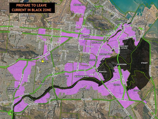
The Townsville Local Disaster Management Group has ordered the evacuation of some Townsville suburbs including Cluden, Hermit Park, Idalia, Oonoonba, Railway Estate and Rosslea.
Chairman of the group Andrew Robinson said rainfall had been higher than expected and the suburbs needed to evacuate before it was too late.
“People living in those suburbs must be prepared to leave. Door knocking if it hasn’t already begun will begin shortly to inform the people in those areas,” Cr Robinson said.
He said the event was not on the same scale as the 2019 monsoonal trough.
“Here we are experiencing an unusual weather pattern, the dam levels may rise to the levels of 2019 according to our worst case scenarios but as with all disaster planning you plan for the worst and hope for the best,” Cr Robinson said.

Mr Crisafulli said the state was concerned about flash and riverine flooding across Cairns to Mackay.
“There’s an emergency alert and it is prepared to leave for a couple of areas both around northern far north Queensland,” he said.
“This is really important that Queenslanders understand that if somebody turns up at your door from police, fire, SES or our friends at the Australian Defence Force, they are there to give you a message and it is important that people heed that message.”
Mr Crisafulli said it was ideal that people did that with friends and family but if they couldn’t do that there were evacuation centres open in Townsville and Innisfail.”
He said he has been in constant contact with the local government.
“Firstly Queenslanders need to know we are well prepared, and I addressed many of you a couple of months ago and said we were putting a lot of resources into preparing ahead of this season and I want Queenslanders to know that we have prepared better than ever before,” he said.
“The most important thing is we get through this without a loss of life.”
That message was reiterated by Queensland Police Deputy Commissioner and Disaster Management Coordinator Shane Chelepy.
Commissioner Chelepy said the event was “very serious and dangerous” and that the next 24 hours forecast would be critical to moving forward.
“We saw some very scary incidents around Townsville with people being washed away in floodwaters,” he said.
“We did see instances where people were walking in no deeper than probably thigh deep water.
“But the rate of the water that was washed away has knocked them over and one lady nearly got sucked in.
“I am pleased to advise, we have no loss of life and no missing persons.
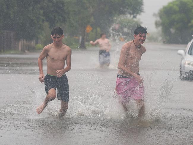
“On the back of that can I please leave a message for people to please stay out of floodwaters.
“We are still seeing behavior of lots of people walking in, playing in or driving through our flood waters.”
Several police officers went door-to-door in Railway Estate on Saturday morning alerting residents of the predicted flooding before conditions worsened.
Low-lying streets had steady swelled with water as the high tide peaked at 11am.

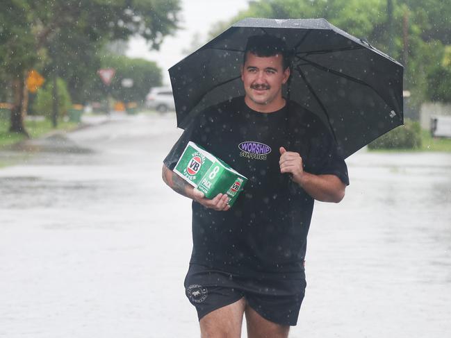
Railway Estate resident Jordan Upton wasn’t phased by the rain, walking home through his flooded street with a carton of Victoria Bitter under his arm.
Mr Upton said their street experienced tidal flooding often.
“It was worse yesterday, I couldn’t get through the street,” Mr Upton said.
Other residents spoke with police but chose to remain inside their homes.
Police planned to door-knock several suburbs over the next two days, including Hermit Park, Idalia and Rosslea.
A low situated on the coast near Innisfail however could deliver intense rainfall with totals of up to 500mm possible in the next 24 hours, the bureau warned.
But what happens next remains uncertain.
The Bureau said it is still unclear whether the system will weaken and dissipate or shift its focus to another part of the state.
Ms Reid said forecasters were monitoring the situation closely, with hopes that monsoon trough dynamics could help weaken the system rather than redirect heavy rainfall elsewhere.
“It’s very hard to say whether it’s going to fizzle out or simply move on,” she said.
“We are hopeful of monsoon trough dynamics come into play... and that focal point may weaken and dissipate rather than just move away.”
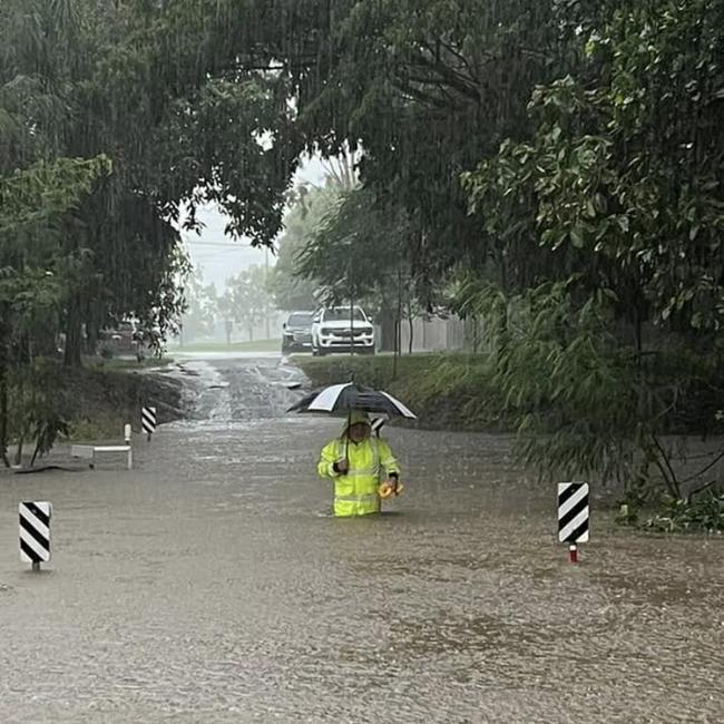
Police have urged the community to be wary on the roads and to keep up to date with the warning after they were called to reports children were in floodwaters in a Townsville suburb.
The call was received about 5.45pm, upon arrival the two children were located out of the water and safe and well.
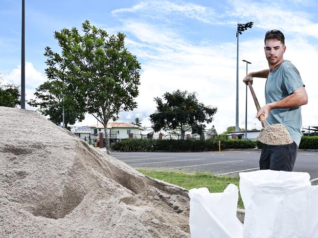
In the 24 hours since 6am January 31, State Emergency Services were called to 306 jobs including 222 in Townsville which were mostly sandbags and tarping.
As of Friday evening, SES had delivered 33,000 sandbags to Townsville City Council.
Major flood warnings remain in place for several rivers, including the Johnstone, Herbert, Ross, and Bohle Rivers.
“The Johnstone River got upgraded to major overnight, there’s a major warning for the Herbert River, and there’s also a major on the Ross and Bohle rivers as well,” Ms Reid said.
The slow-moving nature of the system means rainfall and strong winds will persist across the region throughout the weekend.
“That rainfall is going to keep falling for the next couple of days as that trough system isn’t expected to move away until early in the new week. It’ll be fairly slow-moving, just keeping everything focused in that North Tropical Cassowary Coast region,” Ms Reid said.
“We’re expecting in the next couple of days heavy rainfall, possibly intense rainfall,and damaging winds.”
The warning zone extends along the coastline from south of Cairns to south of Ayr, covering towns including Innisfail, Tully, Cardwell, Ingham, Townsville, Rollingstone, and some inland areas.
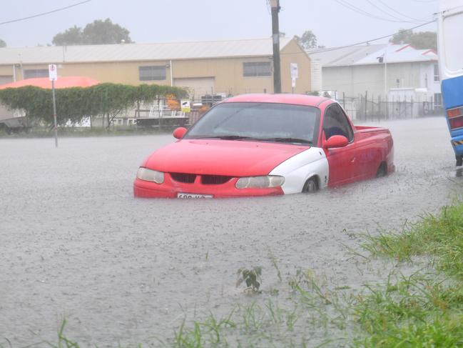
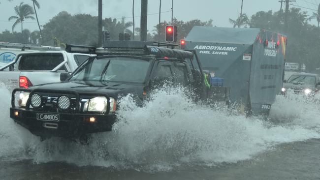
The impacts of the weather system have extended as far south as Mackay, where flash flooding was reported on Saturday morning after 100 to 150mm of rain fell across parts of the city in the past 24 hours.
Further north, Innisfail recorded 200mm on Friday night.
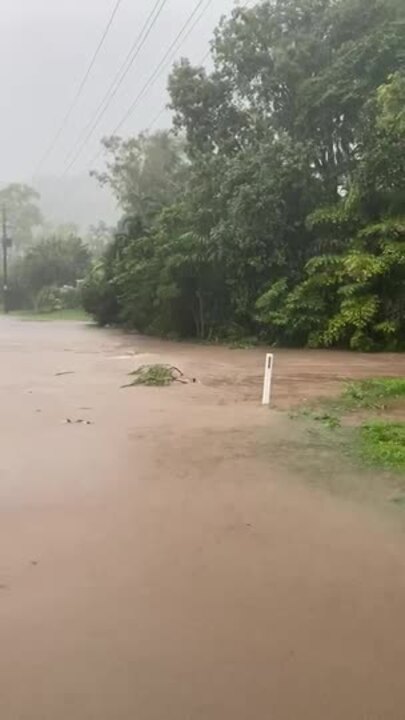
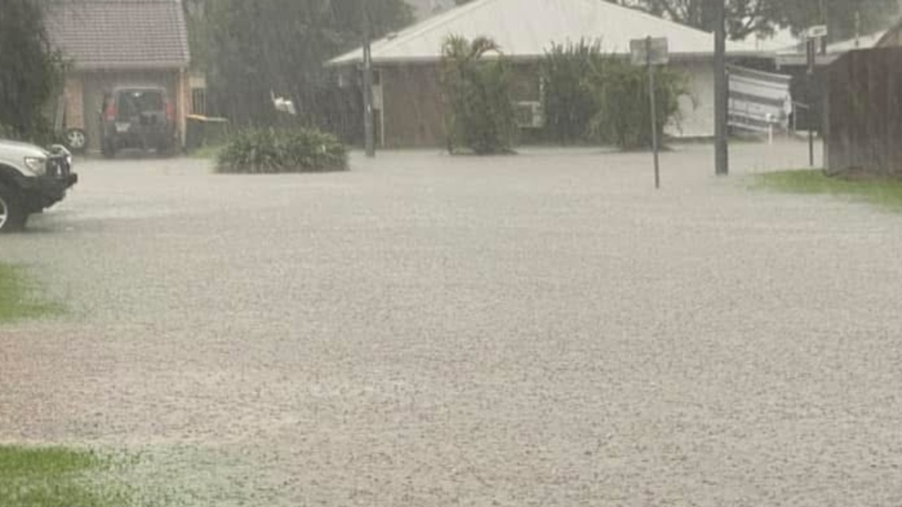
In what has been dubbed the ‘Night of Noah’, biblical levels of flooding fell in parts of Townsville on Friday night, including almost 350mm of rain in 18 hours.
Emergency alerts were issued early Saturday morning for South Johnstone and Mourilyan in the Cassowary Coast region, with authorities urging residents to take immediate action.
A Flood Watch and Act message from the Cassowary Local Disaster Management Group warned that localised flooding was already occurring in the South Johnstone River Catchment, advising residents to leave immediately.
Meanwhile, in Mourilyan, a similar alert from the Cassowary Coast Regional Council cautioned that flooding may occur throughout the day, urging residents to prepare to move to higher ground as conditions could change rapidly.
Queensland Police have begun doorknocking in the worst-affected areas, notifying residents of the potential danger.
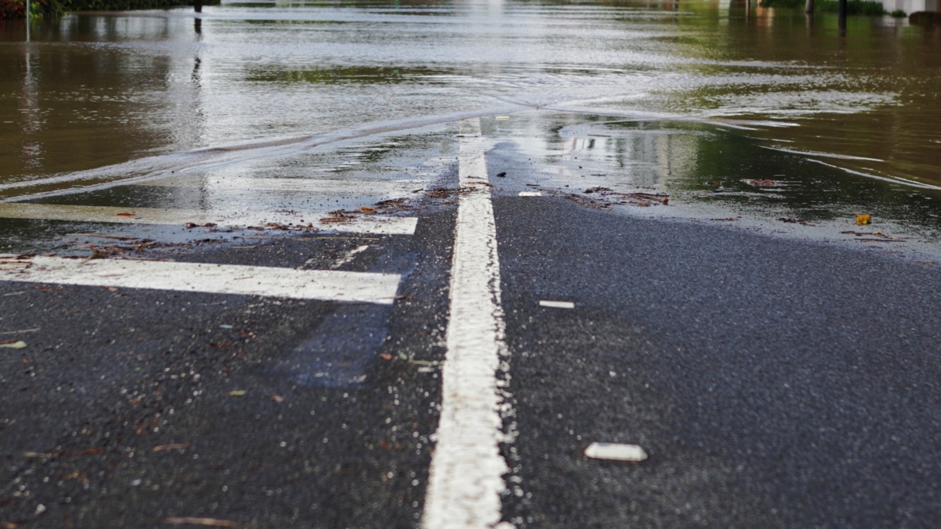
The Bureau of Meteorology warned residents to prepare for more severe and life-threatening flooding after multiple rescues and homes, vehicles and streets were inundated across Townsville.
Local resident Tracy Raiteri whose home is pretty high up, described the rain as the ‘night of Noah’, but said her damage was so far limited to an overflowing pool and fish pond and a leak in her roof.
The ongoing downpour comes as Premier Crisafulli was slammed for his handling of the flood response.
Opposition leader Steven Miles on Friday launched an extraordinary attack on Mr Crisafulli, claiming the Premier is “out of his depth”.
A spokeswoman for the Premier rubbished the claims and said Mr Crisafulli briefed the disaster management group on Friday morning.
“The Premier briefed all members of the QDMC at 11.30am prior to addressing media at 1pm,” she said.
The latest BOM warning showed 24-hour rainfall totals of 200 to 300mm are also likely over the broader warning area, with less widespread falls of up to 500mm.
Residents are also facing strong to damaging winds averaging 0 to 65km/h with peak gusts to around 90km/h from Saturday afternoon for the islands and coastal strip between Innisfail and Townsville.
Townsville’s forecast shows rain continuing over the next seven days with BOM warning the potential for heavy, locally intense rainfall and damaging winds may continue into early next week.
Various flood warnings and watches are in place over Northeast Queensland, including for Townsville, Palm Island, Ingham, Innisfail, Ayr, Home Hill, Cardwell, Tully, Giru, Ravenshoe and Lucinda.
Originally published as Qld weather: Fresh flood threat as NQ slammed with almighty drenching
Join the conversation
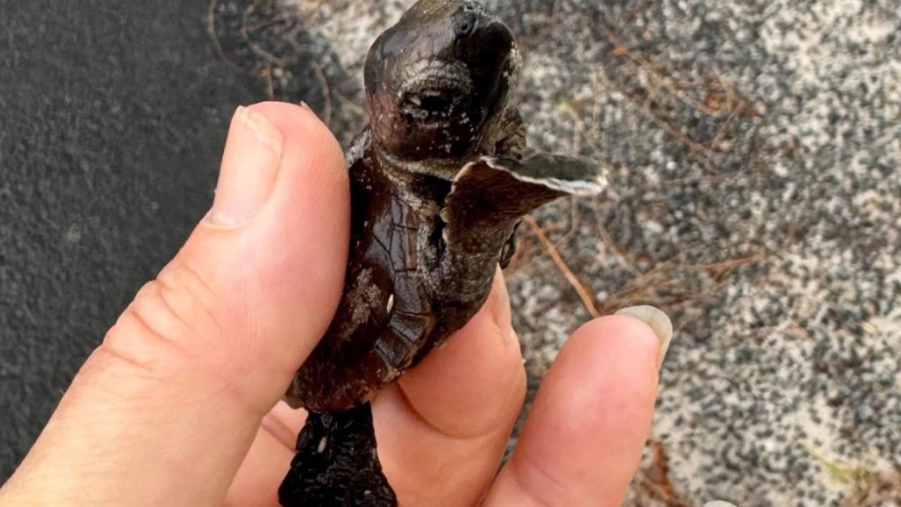
WATCH: Tiny turtles crushed, lost as lights shine on popular beach
Bright lights in a growing Qld seaside town are causing turtle tragedies as tiny hatchlings march the wrong way into traffic and suburbia, a wildlife group says. SEE VIDEO.
Read more
Watch: ‘A lot of rocks, debris’ as roads turn to rivers, airport shut
Roads to key tourism spots are blocked as one operator says it is not safe to be out weather “sightseeing” and planes are diverted across the Mackay and Whitsunday regions. LATEST.
Read more