Chaotic 120km/h wind gusts, intense rainfall forecast to lash Qld as state braces for Tropical Cyclone Kirrily
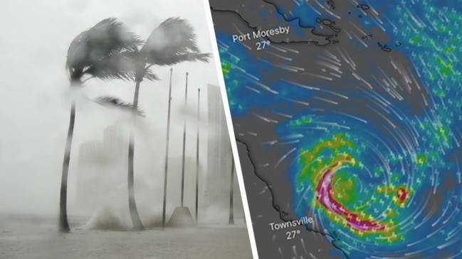
One Aussie state is bracing for the worst amid fears of 120km/h wind gusts and intense rainfall after battling scorching heatwave temperatures.

Queensland, still trying to recover from a Christmas battering, is bracing for a new cyclone which is expected to form as early as Tuesday.
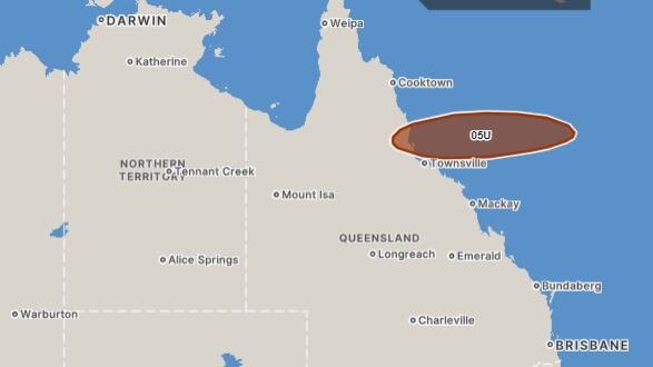
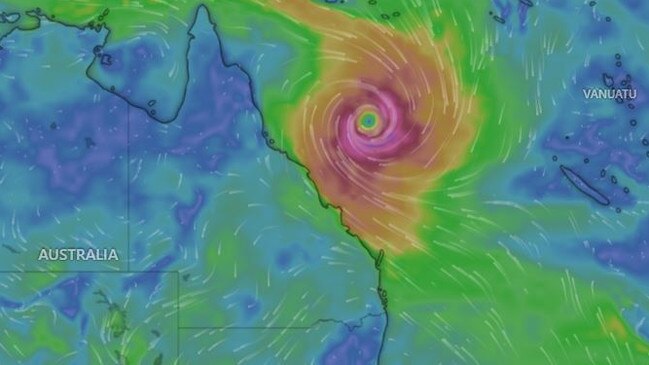
The system expected to develop into Tropical Cyclone Kirrily is building off the far north of the state and is tipped to cross the coast as a category 3 storm in the next few days.
The Sunshine State is facing a hellish week of weather, with Kirrily in the north and a heatwave in the south.
The Bureau of Meteorology said on Monday the system is forecast to cross the coast, most likely on Thursday in the 350km between Innisfail and Airlie Beach around Townsville.
It’s not yet known exactly where the cyclone will cross, but Queensland Premier Steven Miles on Monday said “severe” impact was likely if the system crossing occurred near or south of Townsville.


“It’s then expected to lose intensity and weaken, travel south where it could impact with heavy rainfall around central and southeast Queensland,” he said.
Preparations by the state disaster management authorities was under way.
Already the region has been battered just before Christmas by the aftermath of ex-Tropical Cyclone Jasper, which caused widespread flooding further north around the Cairns and Far North Queensland centres.
Mr Miles said one of the biggest concerns was the “fatigue” of volunteers and emergency services after the hellish summer of storms.
“We’ll be carefully making sure they have all the support and services they need,” he said.
Dams across the affected regions are also being reviewed for possible water releases should they reach capacity from the heavy rainfall.
Shane Chelepy, the state’s disaster coordinator, urged families to be prepared with the right supplies and stay connected with government messaging.
Laura Boekel from the Bureau of Meteorology said the system would likely reach tropical cyclone-strength by Tuesday.
She said the most likely scenario was for the system to cross between Innisfail and Airlie Beach by Thursday.
BOM is expecting large impacts from the weather system over the long weekend.

“We have issued a Tropical Cyclone Watch... current from Ayr to Saint Lawrence, and that includes Mackay and the Whitsundays as well,” Ms Boekel said.
“Gales with damaging wind gusts of up to 120kmh may develop about coastal communities.
“That could extend beyond Wednesday as that system moves closer.”
Ms Boekel said the system was then forecast to move inland and become a tropical low - dumping a large amount of rainfall on the state.
Areas in central and southern inland Queensland could experience heavy rainfalls as a result.
Mr Miles also warned the state was due to exceed its record power demand on Monday due to the scorching heatwave temperatures across the state.
Energy Minister Mick de Brenni assured there was an “adequate” supply of power for Queenslanders on Monday night as people return home and turn on appliances, such as air conditioners.
“This heatwave has been gathering in scale,” he said.
“There remains adequate supply of power... so (Queenslanders) will be able to continue to use their air conditioners tonight, and other appliances as needs be.
“Of course it will be very, very tight.”
On Monday evening, about 40,000 customers lost power.
If the cyclone crosses the coast, it’s expected to weaken to a tropical low before moving south over land, bringing heavy rainfall as far south as Brisbane later in the week.
Residents between Ayr and St Lawrence are being urged to prepare for gale-force winds as fast as 120km/h that could develop as early as Wednesday morning.


Heavy to “locally intense rainfall” is also possible in the path of the cyclone, which could lead to flash flooding inland and possibly on the north tropical coast between Thursday and Friday.
As the system tracks south, it could lead to an inland “rain depression” with heavy rainfall across central, southern and southeastern Queensland.
The bureau has also forecast a possible storm tide between Ayr and St Lawrence as the system approaches the coast.
“Large waves may produce minor flooding along the foreshore,” the warning states.
Temps climb to 44C amid ‘severe’ heatwave
The grim forecast comes as Queenslanders sweat through searing temperatures, some climbing as high as 44C, as a “severe” heatwave warning remains in place.
The mercury climbed to 35C in Brisbane but the “feels-like” temperature was another 6C higher.
Birdsville, on the state’s border with the Northern Territory and South Australia, recorded a maximum temperature of 44C
The bureau has warned the severe heatwave conditions will remain over parts of the state’s southern and eastern regions, extending into central parts of Queensland during the week.
Locations likely to be impacted include Bowen, Birdsville, Bundaberg, Brisbane Metropolitan Area, Gladstone, Ipswich, Longreach, Roma, Thargomindah and Yeppoon.
“Severe heatwave conditions will ease over the southeast coast from Tuesday, including Brisbane, as a milder southeasterly flow develops, but peak over the southwest midweek,” the warning states.


Other states have also been grappled by scorching conditions.
A heatwave warning remains in place for Moree in NSW until Wednesday, with the bureau warning maximum temperatures could climb into the high 30s and low 40s.
Severe heatwave conditions developing over the northeast of the state will contract to the northwest before extending to central parts from Tuesday.
That’s in addition to a severe thunderstorm warning for people in the Northern Rivers, Northern Tablelands and Mid North Coast forecasts districts issued on Monday by the bureau.
Tabulam, Drake, Mallanganee, Baryulgil, Jackadgery and Copmanhurst are likely to be impacted by storms producing heavy rainfall, which could lead to flash flooding.
Sydney can expect a cloudy Tuesday, with a medium chance of showers in the west and maximum temperatures of 25C.
Originally published as Chaotic 120km/h wind gusts, intense rainfall forecast to lash Qld as state braces for Tropical Cyclone Kirrily


