Heavy rainfall, flash flooding possible for parts of south-east
Heavy rainfall with the potential to cause flash flooding could be on the way for parts of the south-east as a wet weather system moves down the coast and inland.
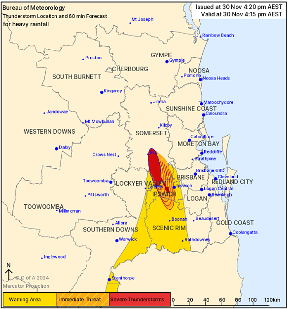
The Bureau of Meteorology issued a warning for severe thunderstorms and heavy rainfall around 1.30pm for regions west of Brisbane, including Ipswich out to Laidley, and down into Northern NSW through Boonah.
Warnings have temporarily eased, though the redevelopment of severe thunderstorms remains possible.

The latest weather warning issued by the Bureau of Meteorology. Credit: Bureau of Meteorology
Meteorologist Shane Kennedy said the bureau would continue monitoring the system’s movements after heavy rainfall was located in a number of locations.
“Spressers Bridge recorded 50 millimetres of rain in 30 minutes to 1.36pm, and Rosewood had 46 millimetres in 30 minutes,” Kennedy said.
“That would be the primary area where we could see that flash flooding, in those western suburbs down through the Scenic Rim, but there is still potential that we could see broader, heavy rainfall and flash flooding mostly extending inland all the way up through southern and central Queensland.”
Heavy rainfall leading to flash flooding was not expected to make it to Brisbane CBD area and the Gold Coast, though rain is due overnight and throughout the remainder of the weekend.
Regions that could see broader river rises and an increased risk of fast acting flash flooding include the Bremer River and Warrell Creek.
“With the rainfall we’ve already seen and continued rainfall, we could see minor flooding along the Warrell Creek this evening and at Amberley near Ipswich on Sunday morning,” Kennedy said.
Brisbane, Gold Coast and Sunshine Coast could all see showers and thunderstorms through Saturday night and into Sunday.
“We’re just starting to have the bulk of this cloud band move across us now so that will likely be the peak of the rainfall,” Kennedy said.
“The most solid rain will be for the next 10 hours or so, but still likely be pretty wet tomorrow...there is the potential to see severe thunderstorms on Sunday with heavy rainfall with a low chance of damaging wind gusts.”
Start the day with a summary of the day’s most important and interesting stories, analysis and insights. Sign up for our Morning Edition newsletter.