This was published 5 years ago
Cairns streets turn into lakes as more heavy rain drenches north Queensland
Hundreds more millimetres of rain have dropped on an already soggy north Queensland with the tropical low responsible moving across the Northern Territory border before heading south.
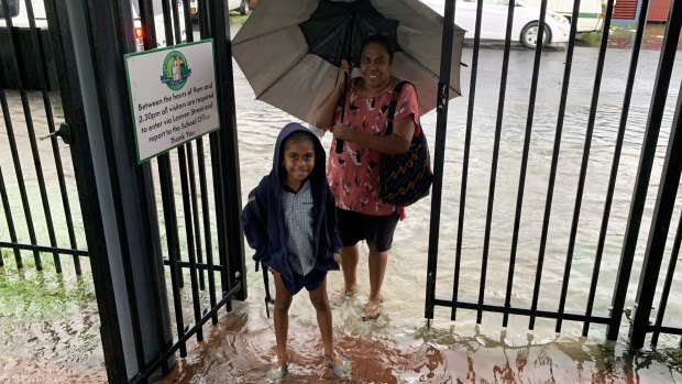
The heaviest drenching occurred in the Cairns region with city streets transformed into lakes and schoolchildren walking to class in ankle-high water on Wednesday.

Flooding near St Joseph's School in the far north Queensland city of Cairns. Credit: St Joseph's School Cairns - Facebook
It came after areas around the Burdekin Shire town of Ayr, about 70 kilometres south-east of Townsville, recorded more than 350 millimetres of rain on Tuesday.
In terms of the latest rainfall totals, the Victoria Sugar Mill, about 100 kilometres north-west of Townsville, had the highest recording with 227 millimetres in the 24 hours to 9am Wednesday.
Meanwhile, in the Cairns region, the Kuranda Railway received 225 millimetres in the same period, Cairns Airport saw 217, Myola had 205 and Cairns Racecourse recorded 195 millimetres.
The Bureau of Meteorology has issued a major flood warning for the Lower Flinders River at Burke Development Road in Walkers Bend in north-west Queensland.
"Moderate flooding is possible at Normanton on the Norman River during the next few days and continues in the upper Flinders catchment in the Richmond area," the warning said.

A student arrives at St Joseph's School in Cairns on Wednesday.Credit: St Joseph's School Cairns - Facebook
"River levels across the Gulf Country are expected to remain below those recorded during the February 2019 flood event."
Meteorologist Peter Markworth said the flood warning was relevant for the weekend, when water levels could peak, with more rain expected in the area this week.
"We know of a few bridges being overcome by floodwaters, which is pretty normal because they are low-lying," he said.
"But we are looking at major flooding this weekend for Lower Flinders River, which is where we will see the biggest rises and risk for people travelling through that area."
A severe weather warning was also in place for heavy rain, damaging winds and possible flash flooding for north-west and western Queensland.
Specific areas under threat included Normanton, Croydon, Kowanyama, Mount Isa, Cloncurry, Camooweal, Urandangi, Julia Creek, Boulia and Bedourie.
Mr Markworth said the tropical low was crossing the Northern Territory border early on Wednesday afternoon, but could still deliver rain for southern Queensland.
"It is making a rapid transition out of Queensland, but there is still have plenty of moisture streaming in around the eastern, south-eastern and southern flanks," he said.
"There are still plenty of showers and storms and potentially heavy falls this afternoon.
"We could see a bit more rain through southern parts of Queensland, not forecasting huge amounts, but conditions increase towards the start of next week."
On Tuesday, the Bureau of Meteorology said the tropical low was not expected to develop into a cyclone, but parts of north Queensland had seen rainfall similar to the 2019 Townsville Floods.
Senior forecaster Gabriel Branescu said there were similarities to the one-in-500-year Townsville floods last February.
"We’ve seen over small areas around Ayr rainfall rates similar to last year, but the difference is this time that convergence zone should actually move further to the north," he said.
"Whereas last year in Townsville we were looking at convergence zone sitting there for seven days in a row, so that makes a difference and makes it not as bad as last year."