By Angus Dalton
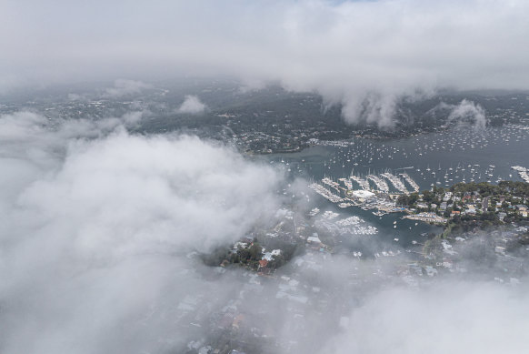
A cold upwelling of seawater off Sydney’s coast meeting warm and humid air sent rare afternoon fog rolling through the city and its beaches on Friday.
Dramatic vision captured thick cloud-like plumes sweeping through the CBD, swaddling the Opera House and Harbour Bridge, and transforming sunny Friday beach visits into grey and misty affairs.
The phenomenon was summoned by a confluence of factors including a temperature inversion – which sees cooler air and fog pinned to the ground by a warmer air mass above – light winds and plenty of airborne moisture, said University of Technology Sydney meteorology expert Dr Milton Speer.
The air temperature over the harbour and the water temperature were both about 21.6 degrees at one point on Friday afternoon, he said, creating ideal conditions for fog.
Moist air was delivered to Sydney by onshore winds.
“The east-to-northeasterly wind that picked up the moisture came from air in contact with the warm water of the east Australian current,” Speer said.
“As it approached the Sydney beaches, it passed over cooler water next to the coast, which caused the moist air to condense into fog.”

Fog on Friday over the Northern Beaches.Credit: Nick Moir
The dew point temperature also comes into play. It’s an indication of when moisture in the air will reach saturation and condense. The higher the dew point temperature, the more water vapour there is in the air.
The dew point temperature by 3pm in Sydney was 21.9 degrees. That’s enough to make the air feel “muggy and uncomfortable”, the bureau said.
Meanwhile, the actual air temperature over Sydney Harbour had reached 22 degrees, just about matching the dew point and hitting the right temperature for moisture to condense into a blanket of fog.
Speer said the phenomenon of afternoon fog was relatively uncommon but happened a few times each summer.
Weatherzone meteorologist Ben Domensino said the abnormally cool seawater that triggered the fog came from an upwelling, in which cold, deep ocean water rises to the surface. The upwelling earlier this week brought a tongue of 17- to 19-degree water to the NSW coast.
The upwelling itself was caused by a run of north-easterly winds pushing away warmer surface water and allowing cool water to surge up.
The phenomenon may stick around to summon more rolling summer fog, Domensino said.
“The presence of this cold tongue of water will increase the likelihood of more sea fog near the NSW coast in at least the first half of December,” he said.
“Anyone venturing to the beach for a dip might also notice that the water feels colder than usual for this time of year.”
The Examine newsletter explains and analyses science with a rigorous focus on the evidence. Sign up to get it each week.