This was published 1 year ago
Sydneysiders warned to limit electricity use as bushfires hit Hunter Valley
By Jessica McSweeney, Laura Chung and Sarah Keoghan
The NSW government was forced to urge Sydneysiders to limit electricity use with energy reserves “under pressure” as the latest heatwave causes bushfires and soaring temperatures across the state.
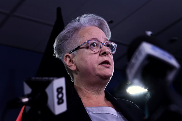
On Thursday, the Australian Energy Market Operator warned the latest heat was expected to lead to a surge in demand and NSW Energy Minister Penny Sharpe called on all businesses and households to reduce electricity use from 5pm to 9pm to avoid blackouts.

Temperatures are forecast to hit 40 again before Christmas.Credit: Sam Mooy
Temperatures soared into the high 30s in Sydney on Thursday, pushing the state’s energy resources to the brink.
With the city reaching over 26 degrees each day for the last two weeks, this has been Sydney’s hottest start to summer on record.
Sharpe said a unit was down in a coal-fired power station, and some units are returning from maintenance on Thursday.
“If you can turn your air-conditioning up a little bit, over 24 is fantastic. If you can make sure you don’t use your dryers or your dishwashers or pool pumps between 5pm and 9pm tonight, that will all help,” she said.
“Every small bit of action that we can take will make it much easier to make sure that the grid stays on.”

NSW Energy Minister Penny Sharpe called on all businesses and households to reduce electricity use from 5pm to 9pm to avoid blackouts.Credit: Kate Geraghty
Government agencies, including schools, were also asked to reduce air-conditioning where safe and turn off non-essential lights and equipment.
The heat also put the NSW Rural Fire Service on high alert.
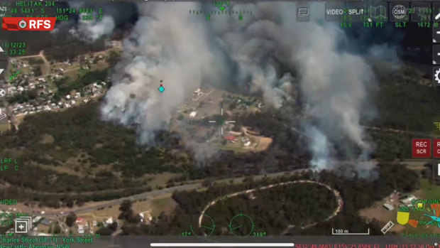
Two fires near Newcastle escalated to emergency level on Thursday afternoon, forcing residents to evacuate.
Just after 3.30pm on Thursday, residents in Cessnock were told their lives were at risk and to leave the area as a fast-moving bushfire ripped through the region.

Multiple crews are in Cessnock fighting the fire.Credit: NSW RFS
The alert was followed by a separate emergency alert for Cameron Park after a truck fire on the Pacific Motorway spread to nearby bushland. Residents in West Wallsend were told to leave the area if they were not prepared to defend their homes. The alert level for both fires was dropped to “watch and act” after 7pm.
As of 6pm on Thursday, 73 fires were burning in NSW. Thirty-five were not yet contained and more than 1000 firefighters and incident management personnel were working on fire grounds across the state.
The hot weather will continue for Friday, with temperatures in western Sydney forecast in the low 30s.
On Saturday, it’s anticipated to reach 38 in the west and the low 30s in the city. The outlook on Sunday is for temperatures to fall back into the high 20s, before another hot week. Richmond is forecast to reach 40 degrees on Tuesday.
The new Penrith Beach will open to the public on Tuesday to give locals some relief from the heat.
The beach will be open every day until March, except for Christmas Day, with the first week used to gather feedback from swimmers to improve the site.
The heatwave sweeping across the state is coming courtesy of a high-pressure area over the Tasman and a low-pressure system over the Great Australian Bight bringing north to north-westerly winds across NSW, Bureau of Meteorology senior climatologist Hugh McDowell said.
“The week from December 17 to 23 shows that for the north of the state and just into the Sydney region we are looking at an increased chance of above-median temperatures,” he said.
While the hot temperatures and bushfire risk will prove nerve-racking for firefighters, Sydney could get some relief just shy of Christmas, with long-range forecasts now pointing to wetter-than-average conditions.
“It could be that we see more severe thunderstorms than fires, but in the short term we have increased bushfire risk, so we should be prepared for that,” McDowell said.
NSW Rural Fire Service boss Rob Rogers said the fire danger would fluctuate as the state enters the peak of the season. While conditions aren’t as severe as they were heading into the 2019/20 season, Rogers remains concerned about the grass growth that three years of heavy rain has fuelled, particularly in areas that burnt in that Black Summer period.
Rogers said that, despite some possible rain, it would do little to minimise the fire risk.
It comes after Sydney suffered through record-breaking temperatures last weekend, when the hottest temperatures since the Black Summer bushfires were posted in western Sydney, and the hottest December day was recorded at Sydney Airport at 43.5 degrees.
A guide to the environment, what’s happening to it, what’s being done about it and what it means for the future. Sign up to our fortnightly Clear Air newsletter here.