This was published 5 years ago
Tropical cyclone pushing powerful swells to Queensland coastline
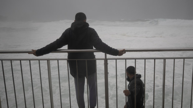
Tropical Cyclone Uesi is forecast to bring large, powerful three-metre swells from Thursday lasting about 13 seconds as it rushes towards Queensland's southern coast and northern New South Wales.
The Bureau of Meteorology said the tropical cyclone would possibly come as close as 600 kilometres to the coast. This would be a similar distance to last year's Cyclone Oma, which crept towards the coastline before turning north-east.

Swells forming from Fraser Island to northern New South Wales are expected to be large and powerful.Credit: Photo: Brook Mitchell
Meteorologist Kimba Wong said she expected at least one more day of heavy rainfall in south-east Queensland before the swells make an impact.
She said the highest rainfall total in the 24 hours to 9am on Wednesday was in the town of Jandowae, near Dalby, with more than 100 millimetres and reports of flash flooding.
Ms Wong said expected rainfall totals would ease into the weekend but light showers and thunderstorms were possible.
"It looks like a little bit of a convergence boundary [is] lining up on the coast so we could see some steady showers and thunderstorms continuing into the evening and early hours of tomorrow morning [Thursday]," Ms Wong said.

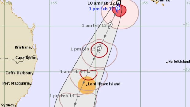
Tropical cyclone Uesi, south-west of New Caledonia, will move in a south south-west direction.Credit: Bureau of Meteorology
Tropical Cyclone Uesi, which is south-west of New Caledonia, was forecast to move south south-west before weakening as it travels over the cooler ocean waters in the coming days.
"It is expected to remain well off shore of the east-west of Australia at the moment," Ms Wong said.
"So we're not going to have a direct cyclone impact on the coast, but what we will see over the next couple of days, particularly over Thursday, is increasing swells on the southern coast of Queensland."
Ms Wong said a hazardous surf warning would be in place on Wednesday afternoon from Fraser Island to northern New South Wales.
"We're expecting two- to three-metre easterly swells starting to become apparent through Thursday and [for] quite a long period as well, so 11 to 12 seconds on that period," she said.
"So it can be quite large and powerful swells over the next couple of days along those southern coastlines."
Ms Wong said the swells would peak on Friday before easing on the weekend.
"Just coincidentally, with the high tides this week, there is the potential of coastal erosion along those beaches on southern Queensland as well," she said.
Meanwhile, Ms Wong said severe to extreme heat was expected to build in north Queensland, with Ingham, the Tablelands and the Gulf Country to endure the worst of it.
She said temperatures would reach the low 40s and there would be little relief during the evenings, with lows of just below 30 degrees in some places.
correction
This original version of this story reported the cyclone would possibly come as close as 600 metres to the coast.