This was published 5 years ago
Year of extremes as record heat, fire danger and dismal rainfall dominate
By Peter Hannam
Australia sweltered through its seven hottest days in December, melting many records including for the country's highest fire danger and its warmest and driest year.
The Bureau of Meteorology said maximum and mean temperatures for 2019 were easily the warmest in data going back to 1910. Daytime temperatures were 2.09 degrees above the 1961-90 average, beating the previous high set in 2013 by 0.54 degrees. Annual mean temperatures were 1.52 degrees above the norm.

Bushfire risks reached record high levels for Australia at the end of 2019, with December heat way above any previous readings for that month.Credit: Kate Geraghty
Globally, 2019 was also the second hottest year on record based on data going back to 1880. It will be the warmest for any year that did not have an El Nino event – a Pacific climate pattern that boosts temperatures – and means the past five years are all among the top five warmest.
While short-term climate drivers, particularly in the Indian Ocean, contributed to Australia's hot year, the background warming – caused by rising greenhouse gas emissions – is clear.
"We've seen clear trends in maximum, minimum and average temperatures across Australia," said Karl Braganza, head of the bureau's climate monitoring, adding the country had warmed about 1.4 degrees since 1910, most of it since 1950.
"We've seen quite clear trends in reducing rainfall across south-west WA and parts of the south-east," he said.
Sydney, Canberra, Brisbane and Hobart notched their warmest year on record for daytime temperatures, while Perth was equal-warmest and Darwin the second-warmest. Exposure to cool westerlies kept a lid on the mercury for Melbourne, but it too had above-average maximums.
NSW broke its annual record for daytime temperatures for a third year in a row, while Victoria had its fourth-warmest. For South Australia, Western Australia and the Northern Territory, 2019 also marked their hottest year for maximums.
Drought intensifies
Rainfall was generally dismal, averaging just 277.63 millimetres across Australia in 2019. That tally was more than one-10th below the previous record low set in 1902.
"Australia had below-average rainfall in every month – it's the first time that's happened," Dr Braganza said.
Each city, except Sydney, had rainfall totals in the driest 10 per cent of years. The city had many months with below-average rainfall and ended up with its driest year since 2005.
NSW and the Murray-Darling Basin both collected less than half their usual annual rainfall, setting new lows and intensifying the drought.
South Australia also had its driest year, with one-third its typical falls, while Victoria had its 10th-driest at just below two-thirds of normal levels.
Three poor winters meant run-off into dams in the Murray-Darling Basin was also very poor, with "no meaningful inflows in the northern basin where storages remained extremely low or close to empty", the bureau said in its annual report.
Year-end blowtorch
Australia started 2019 with an extreme heatwave in January that helped make the 2018-19 summer the country's hottest.
But that record could be eclipsed as soon as this summer after a scorching December that "brought an exceptionally warm end to the year", the bureau said.
On December 18 Australia had its hottest day, with an average maximum of 41.9 degrees. The month also included the next six warmest days, all shading the previous 40.3-degree high set in early 2013.
The week ending Christmas Eve was Australia's hottest week, with an average of 40.5 degrees.
The size of December's temperature leap was perhaps the standout statistic from 2019.
At 38.6 degrees on average, December's daytime temperatures were a full 4.15 degrees above the 1961-90 benchmark, beating a record set only a year earlier, by 1.74 degrees.
December maximums were the largest departure from the norm for any month the bureau has monitored, as were the mean temperatures – averaging out maximums and minimums – at an anomaly of 3.21 degrees.
Nullarbor station's 49.9 degrees last month set a new December record nationally.
"2019 was the extreme year in the sequence [of the past few hot years], but December was the sharp end of the extremes", Dr Braganza said.
Rain clouds were largely absent for the month, with a delayed northern monsoon contributing to Australia's driest December. Rainfall averaged just 15.42 millimetres.
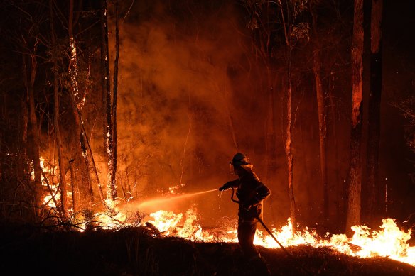
The combination of extreme heat and low rainfall meant the bushfire season started early in many parts of Australia.
The Forest Fire Danger Index – gauging temperature, humidity, wind speed and drought to assess the potential threat of the spread of fire – was the highest on record over most of Australia, including almost all of NSW.
Fire seasons are getting longer – extending as much as a month in parts of south-eastern Australia.
"We're getting more fire weather during the season and the fire weather we're seeing is more severe," Dr Braganza said.