
Red alert: Ilsa makes landfall with record breaking winds
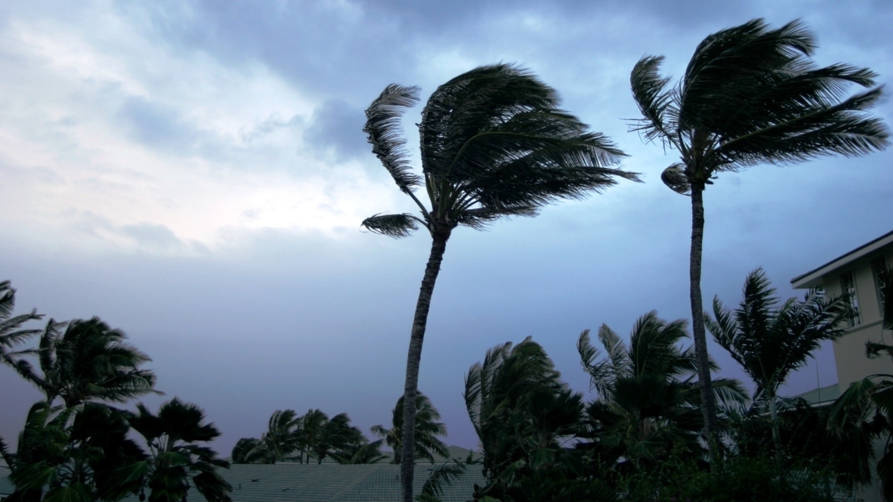
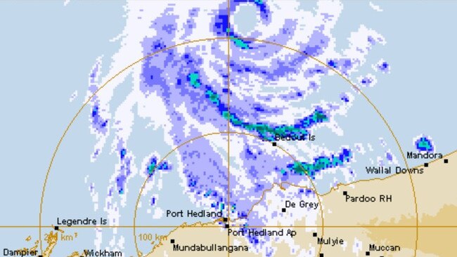
Tropical Cyclone Ilsa has crossed the WA coast between De Grey and Pardoo Roadhouse, with winds gusting as high as 288kmh.
Environment
Don't miss out on the headlines from Environment. Followed categories will be added to My News.
Tropical Cyclone Ilsa has crossed the Western Australia coast between De Grey and Pardoo Roadhouse, with winds gusting as high as 288kmh at Bedout Island.
Ilsa made landfall at around midnight, as a Category 5 storm, with winds at an intensity of 213kmh and gusting up to 230kmh, the Bureau of Meteorology reported.
Earlier the BoM tweeted that Ilsa had broken set a new preliminary Australian ten-minute sustained wind speed record of 218km/h at Bedout Island. The previous record holder, Cyclone George, recorded winds of 194km/h in 2007 at the same location.
#CycloneIlsa has set a new preliminary Australian ten-minute sustained wind speed record of 218km/h at Bedout Island! Cyclone George was the previous record holder with 194km/h back in 2007 at the very same location! For the latest https://t.co/6laIpVWtSMpic.twitter.com/m3jsJCadko
— Bureau of Meteorology, Western Australia (@BOM_WA) April 13, 2023
Ilsa is currently impacting the coastal region between Bidyadanga and Port Hedland, with the destructive winds moving inland from Pardoo Roadhouse.
Ilsa is the biggest cyclone in 14 years, and is set to wreak havoc in communities across the Kimberly.
Authorities issued a red alert just hours ahead of the tropical cyclone making landfall late on Thursday night or early Friday morning, warning of fierce winds up which had already reached 285km/h.
“There is a threat to lives and homes. You are in danger and need to act immediately,” WA’s Department of Fire and Emergency Services (DFES) warned.
“Stay indoors now. It is too late to leave.”
Extremely destructive winds of up to 315 km/h are expected around the centre of Ilsa and will impact areas near Pardoo Roadhouse and De Grey.
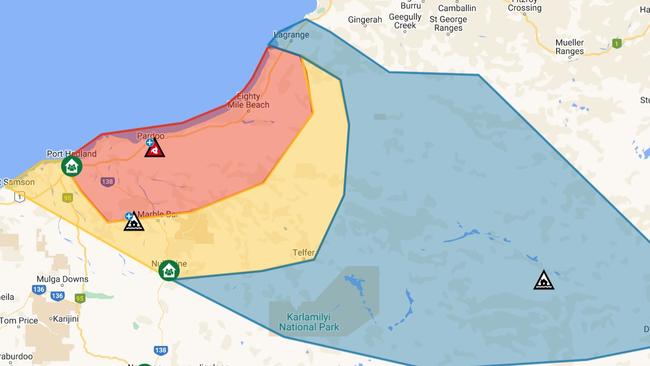
The red alert covers people between Bidyadanga and Port Hedland (not including Bidyadanga) and inland to Marble Bar and Nullagine.
Those in the red alert zone need to seek shelter immediately, and hunker down until the danger has passed.
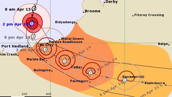
The latest Bureau of Meteorology (BOM) data predicts Ilsa will begin crossing the coast between Broome and Port Hedland about 11pm Thursday, after intensifying to a category 5 system earlier this afternoon.
After it tracks inland, very destructive wind gusts of up to 170km/h will be possible at Telfer throughout Friday if the centre of Ilsa passes close by.
It is the first category five cyclone to cross the WA coast since tropical Cyclone Laurence in 2009.
Earlier in the day, DFES Commissioner Darren Klemm said people should have found suitable shelter, or left the area.
“If you're not sheltered in a [cyclone] rated structure, you need to make your way to an evacuation centre now,” Mr Klemm told reporters in Perth.
“Under a red alert people cannot move around outside.
“Those warning levels are there for a reason … it risks the lives of emergency services who have to go out to protect people in those areas.”
Evacuation centres remain open at Newman, Nullagine, South Headland, and two in Marble Bar.
While Great Northern Hwy between Broome and Port Headland was closed mid-Thursday morning, as Ilsa bore down on the region.
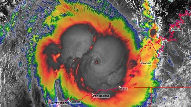
According to the latest BOM update, the system is producing wind gusts of up to 285km/h, tracking 180km north of Port Hedland in a southerly direction at 19km/h.
The Bureau of Meteorology’s Todd Smith said Ilsa would cause a lot of damage to the landscape, and buildings that weren’t up to code.
“We know that this system is really packing a punch,” he said.
“Category five cyclones are incredibly dangerous, with wind gusts in excess of 250km/h,” he said.
“That‘s going to cause a heap of damage to trees, vegetation, if there were any caravans around they would be destroyed.
“Any houses that aren’t built to code are going to suffer extensive damage from that kind of wind strength.”
One gust was recorded at 235km/h on Thursday morning at Rowley Shoals.
Rainfalls of 100-400mm are also likely for some areas.
“Ilsa is expected to turn to the southeast on Thursday afternoon and move towards the east Pilbara coast,” the BOM said.
This satellite loop shows Severe Tropical Cyclone IIsa, moving toward the Pilbara coast and expected to cross early Friday morning as a category 5 system.
— Bureau of Meteorology, Australia (@BOM_au) April 13, 2023
For the latest forecast: https://t.co/YYU1op4qNRpic.twitter.com/sUcxw7bCnc
“During Friday, Ilsa is forecast to maintain tropical cyclone intensity as it tracks past Telfer and further inland across the Northern Interior district.
“The system is expected to weaken below tropical cyclone strength overnight Friday as it moves east into southern parts of the Northern Territory.”
The state’s Department of Fire and Emergency Services (DFES) issued a cyclone yellow alert late on Wednesday, urging those in the affected area to take action and prepare to shelter.
It’s the last step before a red alert is issued, demanding those in Ilsa’s path immediately take shelter to survive.
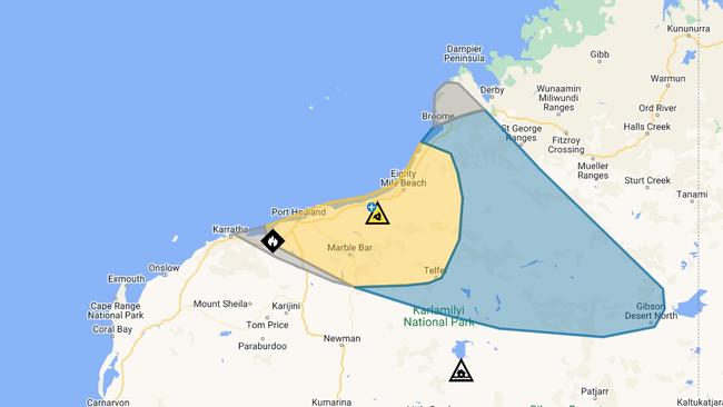
The current yellow alert covers an area from Bidyadanga and Whim Creek, including Port Headland, and extends inland to Telfer.
Almost everyone has been evacuated from Eighty Mile Beach, where there had been concerns over two caravan parks. About 60 caravans were still there on Wednesday morning but by Thursday had been moved to safer areas.
For more information, including the location of evacuation centres, visit the Emergency WA website.
More Coverage

Originally published as Red alert: Ilsa makes landfall with record breaking winds
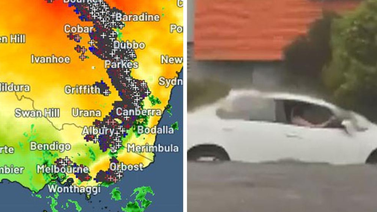
Shock death as storms smash southeast
Wild weather across Australia’s southeast this weekend has turned deadly – with police confirming a camper has died after being crushed by a falling tree.

‘Have a right’: Boss hits back
A boss has hit back after neighbours slammed a $200 million proposal they fear will ruin their views, saying “people have a right to develop”.