
Residents swelter as temp in Adelaide reaches 43C
Aussies in one state are being urged to keep cool as temperatures climb above 40C while other parts of the country battle bushfires.
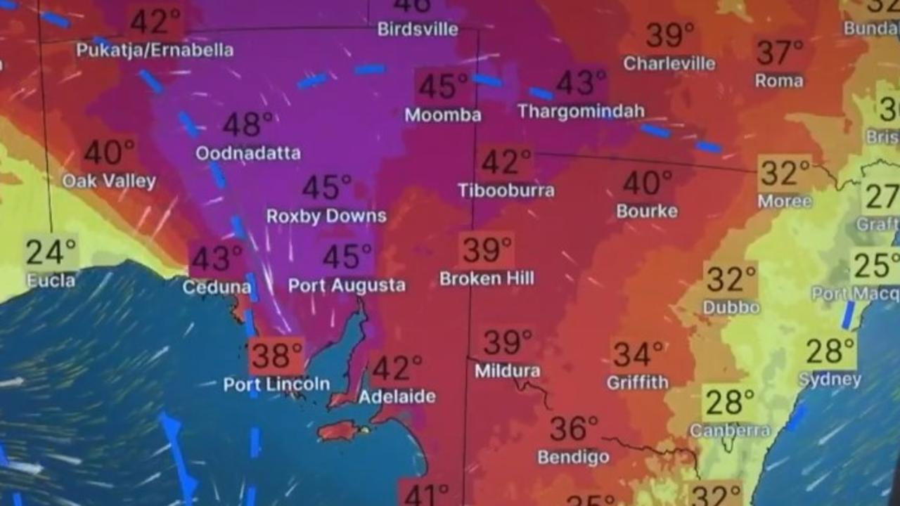
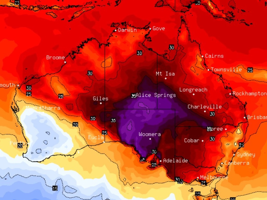
South Australia continues to battle through an intense heatwave, with temperatures reaching 43C in Adelaide.
The rest of the country remains on high alert for potentially “severe” impacts as a cyclone moves towards Western Australia.
A severe heatwave warning remains in place for Kangaroo Island, West Coast, Lower Eyre Peninsula and North West Pastoral districts in South Australia.
A similar warning is also current for the South Interior District in West Australia as well as the Simpson and Lasseter districts in the Northern Territory.
Bushfires continue in Tasmania
Meanwhile, large and uncontrolled bushfires continue to burn in northwest Tasmania.
The Bureau of Meteorology warns the bushfires are creating extremely dangerous conditions at Sandy Cape and surrounding areas.
Emergency warnings remain in place and residents are urged to follow advice of authorities.
Northeasterly damaging wind gusts are also causing problems, with peak gusts up to 90km/h likely to continue in parts of the North West Coast, Western and Central Plateau districts from late Wednesday and continuing into Thursday morning.
Large and uncontrolled #bushfires are currently burning in north-west #Tas, creating extremely dangerous conditions at #SandyCape and surrounding areas. Emergency warnings are in place across these areas.
— Bureau of Meteorology, Australia (@BOM_au) February 12, 2025
Latest forecasts: https://t.co/4W35o8i7wJ or the BOM Weather app. pic.twitter.com/SB9qeaCrZW
Cyclone watch
The bureau warns flash flooding and destructive winds could affect multiple states as WA braces for a cyclone to possibly hit the state.
Tropical Cyclone Zelia is set to move towards the east Pilbara coast and “develop further”, with the area, along with parts of the Kimberley coast, potentially experiencing a “severe impact” on Thursday and Friday.
Broome to Port Hedland (including Port Hedland but not Broome) are in the warning zone, according to the Bureau of Meteorology, while Port Hedland to Dampier and inland to Marble Bar (including Marble Bar) are in the watch zone.
Wind gusts up to 120km/h were recorded about 2am AWST on Wednesday as the category 1 cyclone was about 280km west of Broome and 320km northeast of Port Hedland.
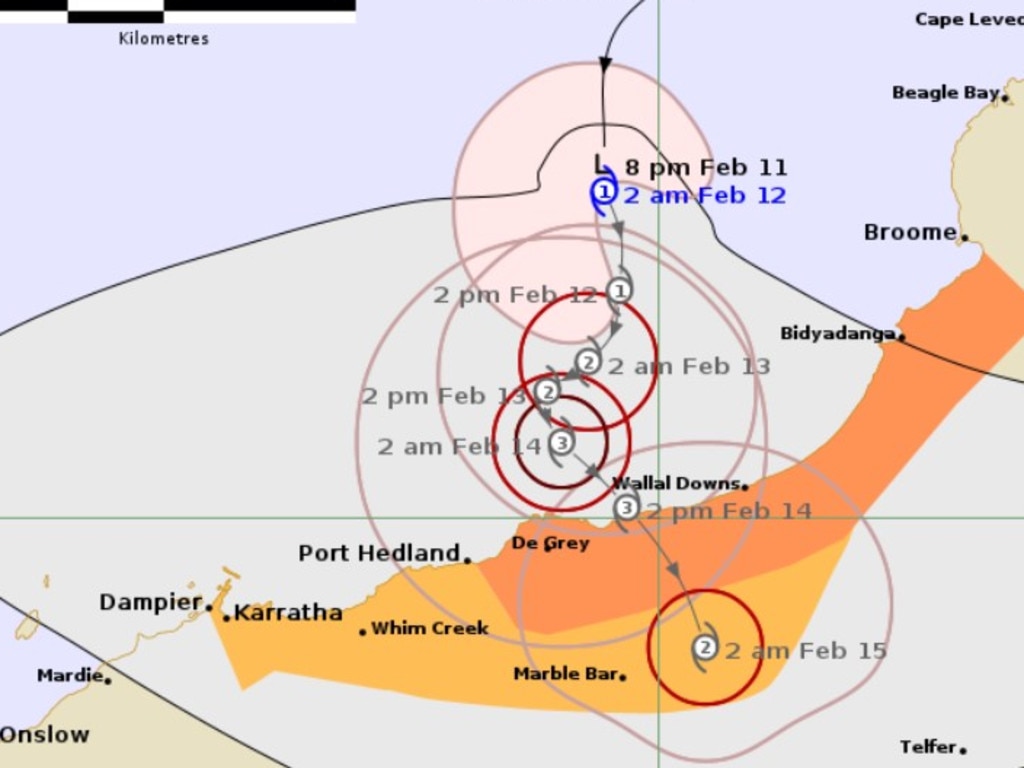
The bureau warned the cyclone could develop into a category 3 by Friday.
“Tropical Cyclone Zelia will move slowly to the south towards the east Pilbara coast. Zelia may develop further to category 3 intensity before crossing the east Pilbara or adjacent west Kimberley coast most likely Friday,” the alert stated.
“The slow movement of the system is likely to produce very high rainfall totals near the track.”
Residents have been warned that damaging wind gusts of up to 120km/h could develop along the coast between Broome and Port Hedland on Wednesday (not including Broome), which could extend to Dampier on Thursday if the cyclone moves further west than anticipated.
Destructive wind gusts of up to 160km/h could develop between Bidyadanga and Port Hedland on Thursday, while heavy to locally intense rainfall could cause flash flooding across coastal and adjacent inland areas.
Isolated heavy rainfall is forecast along the coast of Broome and Dampier, while a flood watch has been issued for catchments in the Pilbara and western Kimberley.
Those in De Grey and Bidyadanga have also been warned of a dangerous storm tide that could lead to tides rising significantly above normal and causing damaging waves and dangerous flooding as the cyclone centre crosses the coast.
Those in affected areas are encouraged to visit Emergency WA for community alerts and to “ensure you know what to do in a cyclone”.
A flood watch has also been issued for the Fortescue River and parts of Sandy Desert Catchments.
Too early to assess full impact of Qld floods
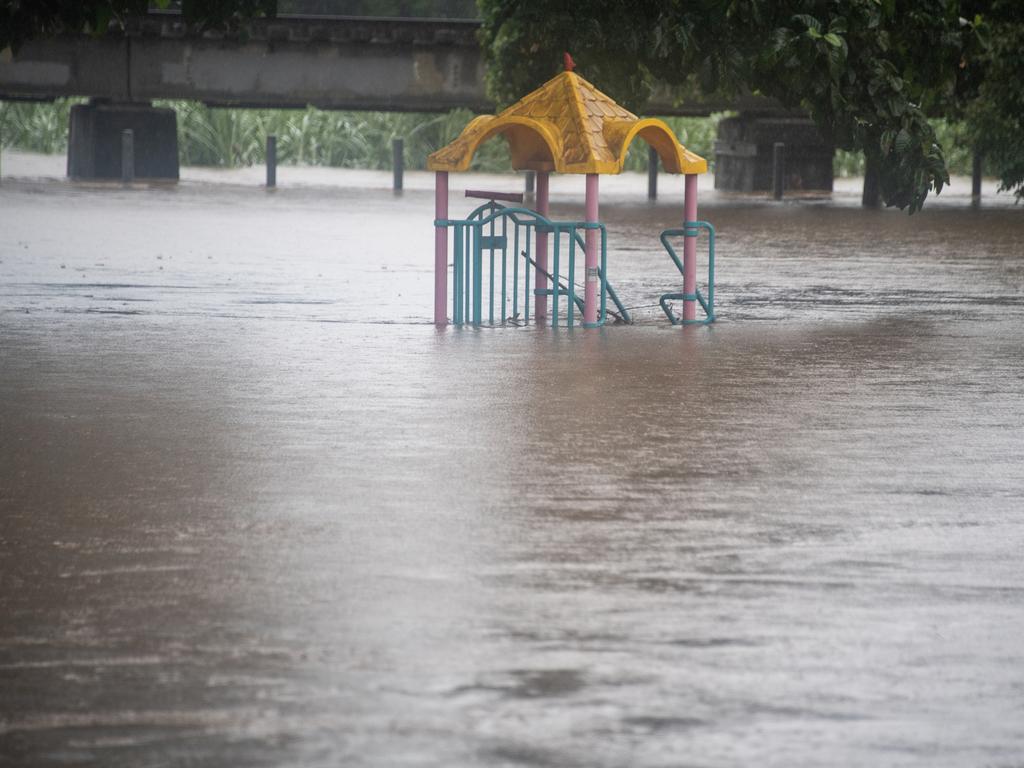
In Queensland, rainfall totals were lower overnight compared with recent days after Far North Queensland was lashed by floods, with two women dead in and around Ingham.
Bureau senior meteorologist Angus Hines said the lower rainfall totals signalled “that the worst of the recent run of extremely wet conditions has passed statewide”.
He said Fisher Creek (112mm) recorded the heaviest rainfall between 9am on Tuesday and 5am on Wednesday.
“Rainfall today could be moderate in the morning before becoming lighter and more isolated throughout Wednesday,” Mr Hines said.
“But renewed river rises are still possible with the ground being so wet and catchments already swollen.”
Major flood warnings have been issued for the Flinders and Herbert rivers.
Moderate flood warnings are in place for the Cape River, the upper and lower Burdekin River, the Connors and Isaac rivers, the Haughton River catchment, the Ross, Bohle and Black rivers and Thomson River.

Minor flood warnings have also been issued for the Suttor, Barcor, Albert, Tully, Murray and Western rivers, while a flood warning is on place for the Nicholson, Gregory, Diamantina, Norman and Gilbert rivers.
It remains too early to determine how many homes and businesses have been affected by the floods in Ingham, Hinchinbrook Shire Council Deputy Mayor Mary Brown said according to the Townsville Bulletin.
“Door knocking is still going on in relation to the number of impacted properties but what you do see when you come into Ingham is piles of heartbreak,” Ms Brown said.
“Piles of heartbreak, people’s possessions that are out there on the footpath and it’s the same with businesses here.”
A shower or two has been forecast for Ingham on Wednesday with a high of 31C, with Brisbane tipped for the same.
Sydney is set for days of possible showers extending from Wednesday all the way to Saturday, with temperatures tipped to reach a high of 30C.
Melbourne is set to hit a high of 37C on Thursday despite possible showers through the week, while Perth is expected to reach a high of 36C on Saturday.
Adelaide is in for a scorching high of 43C on Wednesday before the temperature drops to 27C on Thursday, while Hobart is set to hit 33C on Thursday a 23C day on Friday.
Canberra is tipped to hit a high of 30C on Thursday, while Darwin is forecast to hit the early 30s with possible storms across the week.
Originally published as Residents swelter as temp in Adelaide reaches 43C

