
Polar air blast to sweep through most states bringing freezing start to winter
A brutal blast of polar air is set to sweep through most of the country, with parts of the country seeing temperatures hit -3C.


Environment
Don't miss out on the headlines from Environment. Followed categories will be added to My News.
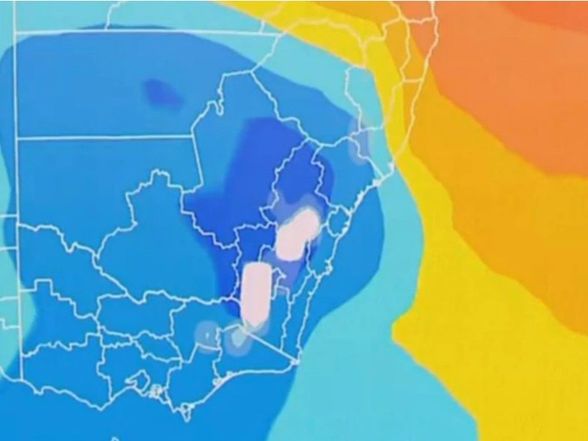
A blast of polar air is set to hit Australia’s south and east with the end of Autumn bringing freezing temperatures, showers, snow and brisk winds.
The strong cold front and low pressure system is set to sweep through parts of Western Australia, South Australia, Victoria, Tasmania, eastern NSW and parts of southern Queensland.
The rapid transition into the wintry weather pattern will hit just in time for June 1 with some communities experiencing the coldest temperatures of the year so far.
The Bureau of Meteorology has warned that the major cold outbreak will break most winter records, let alone records for the last days of Autumn.
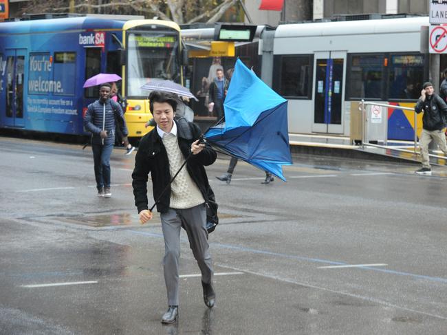
Weatherzone Meteorologist Joel Pippard said the system will result in a “broad area of damaging winds”, which could stretch from Perth right through to Brisbane and Hobart.
“Large accumulations of small hail, moderate rainfall leading to some minor flooding and low-level snow are possible,” Mr Pippard said.
WESTERN AUSTRALIA
The cold blast will first be felt across southern WA on Saturday, with Perth experiencing heavy showers.
WA’s south coast will suffer through heavy rains, gusty winds and thunderstorms on Saturday before the wet weather extends to the Eucla district throughout Sunday.
BOM is forecasting heavy rainfall over both northwest WA and the Pilbara Coast, with totals of up to 60mm expected to call.
“Isolated falls up to 80mm are forecast over the Flood Watch area for Saturday,” BOM said.
“Further rainfall totals of 50 – 90mm with isolated totals up to 120mm are possible on Sunday.”
SOUTH AUSTRALIA
The cold front will move through South Australia on Sunday morning where it will remain for most of the day, with intense showers, gusty thunderstorms hitting the area until Monday.
The BOM has warned that a severe weather warning could be issued for damaging wind gusts.
“Temperatures in South Australia will likely be the coldest or nearly the coldest day of the year so far for many locations,” the bureau said.
Adelaide is expected to see temperatures of just 9C in the early hours of Sunday morning.
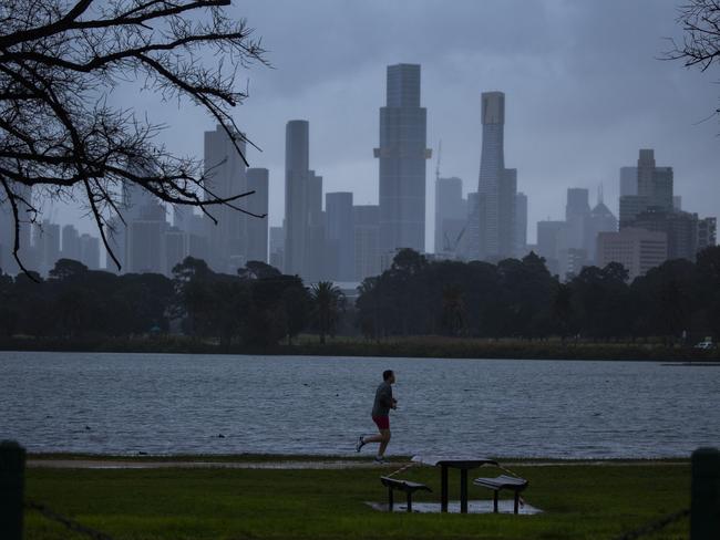
VICTORIA
Victoria will start experiencing the cold front over Monday and Tuesday with gusty showers, strong winds and possible storms.
Melbourne’s temperature on Monday could drop to 7C, while Bairnsdale in the state’s west could hit 6C.
Snowfall is definitely expected with blizzards possible around alpine peaks on Tuesday.
Severe thunderstorm and severe weather warnings for damaging winds may be issued by BOM for the early parts of the week.
Victoria may also experience cold air thunderstorms throughout Tuesday, with small hail possible.
“Snow level expected to lower to 1200 metres on Monday, then to near 700 metres on Tuesday,” BOM said.
NEW SOUTH WALES
The burst of wintry weather will break into NSW on Monday and Tuesday, beginning with freezing gale force winds.
BOM has said it may issue a severe weather warning.
“The cold front may bring significant rainfall to the state’s southern inland, mainly around western parts of the central and southern ranges,” BOM said.
“Snow is expected in the Alpine region, with a chance of snow around higher parts of the ranges outside of the Alpine region extending as far north as the Central Tablelands.”
Parts of the NSW east coast are expected to be met with strong winds late on Monday and well into Tuesday.

Temperatures in Sydney are expected to drop to as low as 7C on Thursday morning, while areas in the city’s west will see lower temperatures.
Penrith is forecast to wake up to 6C, while Camden in the southwest will wake to 5C.
Parts of the state’s central west such as Dubbo, Coolah and Mudgee wake to -1C.
Lithgow, Orange, Bathurst and Crookwell will see temperatures of -2C on Thursday morning as the cold blast sweeps through the state.
Armidale in the NSW Northern Tablelands is expected to be the coldest part of NSW with early morning temperatures reaching just -3C on Thursday.
QUEENSLAND
The cold blast will move north towards Queensland throughout the middle of the week, just in time for winter.
Thursday expected to be the coldest day of the year so far for the sunshine state.
Southern parts of the state will wake to morning temperatures of just 1C, including Stanthorpe and Applethorpe
Meanwhile Brisbane is expected to reach a low of just 6C on Thursday.
TASMANIA
Strong and potentially damaging winds are being forecast as a result of the cold front in Tasmania.
The island state will also experience a huge drop in temperatures and snow as low as 700 metres on Tuesday evening and Wednesday morning.
Tasmania will also endure small hail and cold weather thunderstorms while the weather system remains.
Originally published as Polar air blast to sweep through most states bringing freezing start to winter
Group to be hit first and hardest by cyclone
These residents are going to be hit first - and the hardest - by Tropical Cyclone Alfred as it approaches the coast, the latest forecast shows.
Grim warning for flood-smashed town
Residents still recovering three years after a destructive flood are “dreading what is to come” as Cyclone Alfred barrels towards them.