
‘Monsoon’ in northern Australia forecast to bring up to 500mm falls amid wild weather across eastern, southern states
Storms which could drop up to 500mm of “monsoon” rain on some parts of the country have been forecast for Aussies, amid a wild week of storms, floods and heatwaves.

Environment
Don't miss out on the headlines from Environment. Followed categories will be added to My News.
Aussies across the country are bracing for wild weather, with “monsoon” rains forecast to drop up to 500mm across parts of the country.
The grim prediction follows huge storms plaguing Queensland and Victoria, while a heatwave grips South Australia and parts of Perth, WA over the freak summer season.
Northern Queensland, the Top End and the Kimberley are set to be soaked over the coming week as a long-awaited monsoon brings heavy rain.
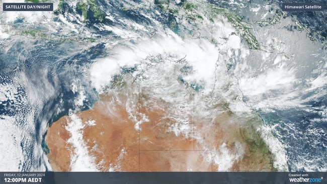
Satellite images reveal huge clouds stretching across thousands of kilometres in Northern Australia, holding the rain that is expected to fall for the next two weeks.
QUEENSLAND
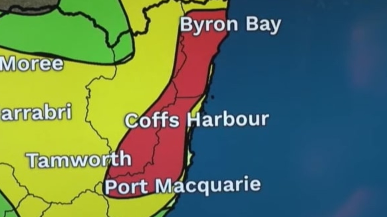
Over the next seven days, widespread falls exceeding 100mm are forecast across the northern most parts of the country, including Cairns, Townsville, and Darwin.
Some areas could surpass up to 300mm and 500mm of rain before the week is out, including areas of Queensland that have already been ravaged by floods.
An “area of convergence” within the monsoon trough is particularly concerning for those on the northeast of Queensland, WeatherZone meteorologist Ashleigh Lange said.
“This prompted a severe weather warning on Friday morning for heavy rainfall, flash flooding and a minor flood warning in the Port Douglas and Daintree area,” she said.
There are fears that the fresh storms could hamper or even reverse recovery efforts for those impacted by ex-Cyclone Jasper which ravaged Far North Queensland.
Residents in places like Cairns and Port Douglas have spent the past month cleaning up the mess left by the cyclone.
Cairns mayor Terry James urged the local community to prepare for the possibility of further road closures and power outages in the coming weeks, with the newly arrived monsoon signalling the start of the wet season, which is seen as the north’s disaster season.
“It doesn’t finish until the 20th of April, so you really do need to be prepared,” Mr James said.
“Our biggest fear is complacency and I think we saw that a lot with the last event.”
The Douglas Shire Council has advised residents to conserve water due to local water infrastructure being impacted by rainfall.
Rainfall is picking up across already soaked areas, with the Bureau issuing a number of flood warnings over concern that menacing.
Flood watches are in place for the Daintree River and Mossman River, with up to 270mm falling in the catchments to 9am on Friday.
“With further significant rainfall, renewed rises are possible and minor flooding may redevelop along the Daintree River,” the Bureau of Meteorology warned.
Also impacted by flood warnings are the Mulgrave and Russel Rivers south of Cairns, with up to 115mm recorded in those catchments to Friday.
Flood warnings are also in place for the Paroo, Barco, Bulloo, Tully, Diamantina, and Dawson Rivers.
Each year, the north’s wet season is launched by a monsoon bringing seasonal north-westerly winds with and thunderstorms, usually around mid December.
Thanks to El Nino, this year’s wet weather has arrived late and it’s a welcome relief to many locals who suffered through oppressive heat and humidity during the “build-up” of the storm.
“Darwin had its hottest start to a year on record due to the tardiness of the monsoon this season,” Ms Lange said.
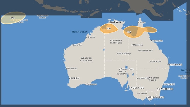
She also warned that the monsoon increases the likelihood of any low pressure system turning into a cyclone, especially if a storm system remains over warm water for several days.
“Forecast models suggest that three separate tropical lows could form in the Australian region during the coming week,” she warned.
“However, these lows only have a low risk of becoming tropical cyclones at this stage.”
NORTHERN TERRITORY
The Bureau of Meteorology has warned that flooding is possible in North Western Rivers, Bonaparte and Western Areas of Carpentaria as the monsoon trough drifts slowly southwards.
With a tropical low sitting off the west coast of the Top End, residents in the flood watch areas are warned to expect heavy rainfall that can quickly make catchments very wet.
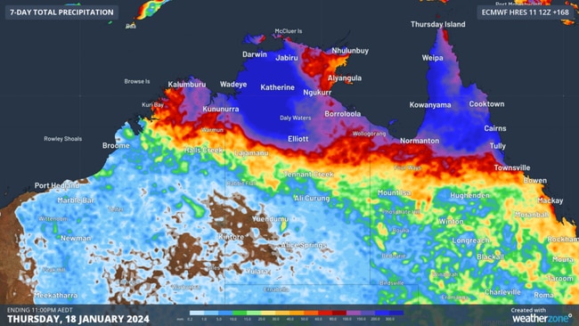
The monsoon could bring widespread daily rainfall totals of between 50 and 150mm, with some areas to be showered with even more water.
“More widespread heavy rainfall is likely to develop later in the weekend as the monsoon strengthens,” the Bureau warned.
“Significant river, creek, and stream rises are likely with heavy rainfall, with possible minor to major flooding across the Flood Watch area during the next week.”
Residents are warned that many roads including major highways could be affected by the weather system and that some communities and homesteads may become isolated.
Catchments that are likely to be affected include the Victoria and Katherine Rivers, as well as Fitzmaurice, Mary, Adelaide, Finniss, Daly, Moyle, South Alligator, Wildman and Waterhouse rivers.
SOUTH AUSTRALIA
While the northern parts of the country deal with wet weather, parts of the south are battling through hot conditions.
South Australians are currently sweating through the tail end of a five-day heatwave that brought temperatures into the mid-forties.
“Extreme heatwave conditions are expected over western parts of the North West Pastoral district until the end of the weekend, while severe heatwave conditions over western SA are expected to ease during early next week,” the Bureau warned.
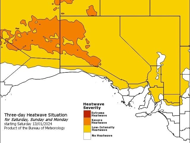
Locations to be the most affected include APY Lands, Oak Valley and Roxby Downs, which will experience a 42C degree on Saturday before the heat is dialled down slightly to the high 30s until Wednesday.
Adelaide residents will also be sweating over the weekend, with highs to remain in the 30s until Tuesday.
VICTORIA
Just to the east, Victorians are still under siege from rain and floods as the Bureau issues a number of warnings for affected residents.
Flood warnings are in place for the Goulburn, Murray, Latrobe, Loddon, Thomson and Yarra Rivers along with the Seven Creeks.
The Goulburn River from Seymore to Shepparton peaked at 10.34 metres at 10pm on Friday and water levels are expected to remain above 9.50 overnight on Saturday and into Sunday with a “small renewed rise possible as flow from upstream tributaries arrives” according to the Bureau.
“The Goulburn River at McCoys Bridge may exceed the minor flood level (9.00 m) during Saturday. A peak near the moderate flood level (10.00 m) may occur during Sunday or Monday,” the Bureau warned.
Those in the Central, North Central and Northern Country areas have been warned of damaging winds due to a low pressure trough moving northwards over Saturday “with a strengthening southerly flow developing in its wake” according to the Bureau.
Winds averaging between 50 to 60 km/h are expected as well as “damaging wind gusts” of around 90 km/h from early in the evening and overnight.
Locations expected to be the most affected include Seymour and Kyneton.
Originally published as ‘Monsoon’ in northern Australia forecast to bring up to 500mm falls amid wild weather across eastern, southern states
Two Aussie states bracing for severe storms
Two Australian states are bracing for wild weather that could lead to power outages and damage to cars and homes.
Read more

‘Whole world’: Wong’s climate demand
With Australia’s Pacific neighbours on the frontline of climate change, Penny Wong is calling for the “whole world” to cut back emissions.
Read more