
Could summer be ruined? Climate signs point to another horror bushfire season
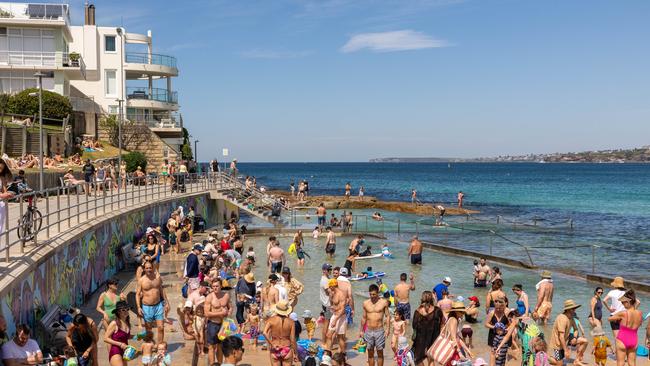
Australians have been making the most of the unseasonably high temperatures, with sunseekers flocking to beaches across the country. But as the mercury soars, concerns rise.

Climate Change
Don't miss out on the headlines from Climate Change. Followed categories will be added to My News.
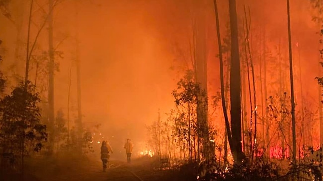
It may only be spring, but some Australian residents already feel like we’re in the middle of January with the amount of bushfire activity across the nation since the end of winter.
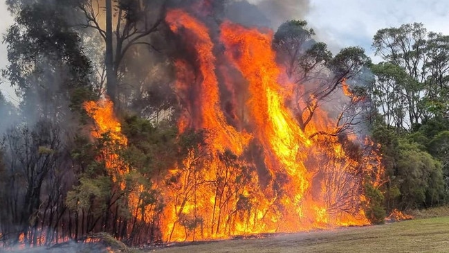
At least three homes were lost to bushfires on the New South Wales Far South Coast in the first few days of October as emergency-level blazes were sparked near the coastal community of Bermagui, in the Bega Valley.
It’s promoted warnings from fire authorities that large parts of Australia could be heading for a potentially catastrophic bushfire season, with Black Summer still fresh in the minds of those affected.
The 2019-20 bushfire season was one of the worst overall in recent history, with about 24.3m ha of land burned, nearly 2800 homes destroyed, and at least 34 lives lost.
At the peak of the fires, between December and January, all southern and eastern states had their air quality levels drop to hazardous levels; people outdoors had to go about their business wearing masks, and those looking to escape the heat at the beach were met with ash cover and red skies.
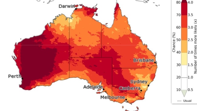
The Bureau of Meteorology (BOM) on Thursday released further data on their long-range summer weather predictions.
“For November to January, above median maximum temperatures are very likely (greater than 80 per cent chance) for almost all of Australia,” reads their report.
BOM also predicts we’re “at least 2.5 times more likely than normal to experience unusually high maximum temperatures, with chances increasing to more than four times more likely for central and western WA,” in the same November to January period.
It's been a busy period for firefighters, with almost 400 fires occurring across the state since last Friday, including the Bega Valley, Mid-Western, Hunter and North Coast areas. Unfortunately, while we have seen some property loss, there have been many more saved. pic.twitter.com/y4kvB3r5Zi
— NSW RFS (@NSWRFS) October 5, 2023
Here’s the available outlooks on bushfire activity by state and territory:
NEW SOUTH WALES
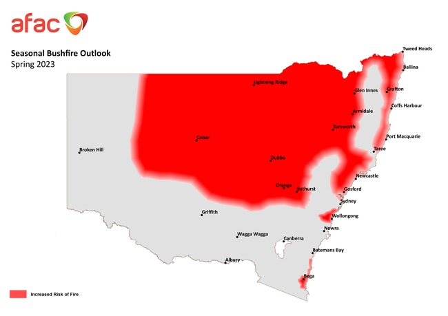
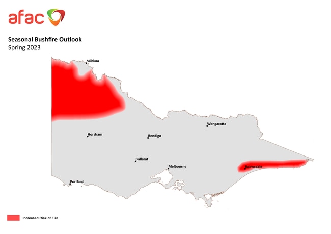
The Australasian Fire And Emergency Services Authorities Council (AFAC) released their seasonal bushfire outlook for spring on August 23.
It included NSW as one of the jurisdictions at increased risk of bushfires this coming 2023-24 summer, with large areas of the state’s central and northern regions to be of most concern.
Drier-than-average weather conditions and large, persistent grass loads means the bushfire danger period has started earlier.
High forest fuel loads are also likely to pose a problem for areas not affected by the devastating 2019-20 bushfire season, mainly around the Sydney Basin, coastal regions, and north of the Hunter.
The severity of the 2019-20 season means the regrowth in areas affected have changed their structure, and have recovered after three wet La Niña years.
Higher than average soil moisture and low frost curing (when freezing conditions actually cause grass to become dried out and therefore more dangerous) in the NSW southwest means those areas will have a normal bushfire season this spring.
However, AFAC warns warmer conditions and spring growth could see that change quickly.
NSW Premier Chris Minns on Wednesday warned residents in his state to “be prepared for horror summer”
“If you are on holidays … it’s really important you understand where evacuation centres are,” Mr Minns told reporters.
AUSTRALIAN CAPITAL TERRITORY
The ACT will largely face normal bushfire conditions due to three wet years and plenty of water held in catchments.
But long-range forecasts predict drier-than-average conditions and high-than-average day and night-time temperatures across the nation’s capital.
AFAC urges ACT residents to stay vigilant heading into summer.
“Residents should review, update, or prepare their Emergency Plans in anticipation of the high-risk
weather season,” reads their spring report.
“Emergency Plan templates can be accessed at the ACT Emergency Services Agency website.”
VICTORIA
The three wet years means much of Victoria’s soil has plenty of moisture. However, that does lead to higher grass growth.
Weather forecasts predict a drier and warmer spring, so bushfire season will occur earlier than usual in central, western, and northern Victoria.
Elevated grass fuel loads in agricultural areas are a concern, especially if they’ve been cured over winter.
Dry forecasts for the forests, woodlands, and heathlands will also be monitored, especially if conditions become hot and windy.
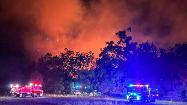
The state’s Country Fire Authority (CFA) has already declared the fire danger period (FDP) will start for the Wellington and East Gippsland Shire Councils from Monday.
CFA Chief Officer Jason Heffernan said the FDP declaration is earlier this year, which is an indication of what can be expected for the summer ahead.
“While crews are ready to respond and support communities this bushfire season, fire safety is a shared responsibility and we ask Victorians to prepare and know their local risks,” he said.
“We are asking anyone burning off in the next two weeks before the official FDP begins to be very careful.
“Take this opportunity ahead of the FDP to clean up your property, prepare your bushfire plan with your family and download the VicEmergency app.”
TASMANIA
Although there’s been below-average rainfall on the island state’s east, bushfire conditions are predicted to be typical for much of Tasmania.
However, AFAC said there’s a “significant” contrast for climactic bushfire events this spring compared to previous years.
The combination of El Niño weather effects, and the chance of a positive Indian Ocean Dipole (difference in sea surface temperatures), could increase the drying effect across the state.
The three years of wet conditions have also caused an increase in the growth of fuel loads.
SOUTH AUSTRALIA
Rainfall across the state was way above-average in the early part of winter, before rapidly switching to below-average in July.
That means the bushfire danger has gone from below-average to above-average across much of the state’s south.
SA’s southwest is of particular concern, as below-average soil moisture and higher rates of “evaporative stress” put pressure on bushfire conditions.
Above-average springtime temperatures also mean an increased risk of grassland fire in the SA-Victoria border regions, and also for Mallee Heath areas across southern SA approaching the Victorian border.
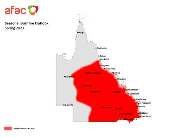
QUEENSLAND
Despite some states experiencing three years of wet winters, Queensland has had general rainfall totals “significantly” lower-than-average over the last two years.
This means there’s reduced soil moisture rates across subtropical and temperate zones, and therefore an increased fire risk.
Significant rainfall across central and northwestern parts of the state has delayed the onset of the bushfire danger season, but if there isn’t mid-spring follow-up it means the grasslands in these areas will be at risk in late spring and early summer.
The state’s rainfall patterns means vegetation growth will be similar to traditional post La Niña growth patterns.
AFAC said the combination of these factors means fires will be “locally intense” as that vegetation becomes dry and flammable.
WESTERN AUSTRALIA
Average springtime conditions means increased bushfire risk in WA’s Pilbara region is unlikely.
However, above-average wet season rainfall in the Kimberley means the late onset of the dry season, so late spring will be a concern for the state’s Department of Fire and Emergency Services (DFES).
Moisture in the state’s South West is likely to be below-average across spring, and prompt greater-than-average vegetation growth late in the season.
Communities are urged to stay alert, with more information available from the DFES website.
DFES Commissioner Darren Klemm in a September media conference said forecasts predicted a “difficult summer.”
“We‘re anticipating the bushfire season is going to come forward because the forecast is for not a lot of rain during spring,” Mr Klemm said.
“Now is a really good time for people out in the community to revisit their bushfire plan.”
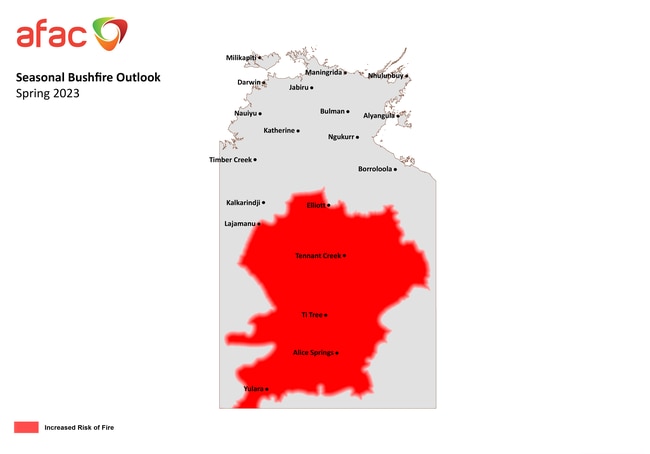
NORTHERN TERRITORY
It’s been challenging for fire managers to access some areas around Darwin, Katherine, and the Victoria River Region to conduct early dry season mitigation burns because of soil moisture levels.
There have been more than 3000 wildfire incidents in urban and peri-urban areas between June and August, which have created suitable fire-scar coverage in the Northern Savanna, Top End, and Arnhem regions.
However, significant rainfalls in the Barkly and Central Australia regions across June spurred on further growth of already above-average grass fuel loads.
With minimal fire scar coverage, well-above average fuel loads, above median temperatures, and dry, windy conditions, increased fire risk is predicted for the Barkly, Tanami, Alice Springs and Lassiter forecast regions.
LOOKING TO SUMMER
AFAC CEO Rob Webb said he’s always asked if the coming summer will be another Black Summer.
“The strong retort is it doesn’t need to be a black summer to be dangerous,” Mr Webb said.
“We don’t need reminders given what’s happened with the northern hemisphere fires, whether it be Greece or Canada, where we’ve had 700 Australian firefighters and other specialists.”
“Almost the entire country can expect drier and warmer conditions than normal this spring, so it is important for Australians be alert to local risks of bushfire over the coming months, regardless of their location.”
AFAC is expected to release their summer seasonal outlook at the end of November.
Originally published as Could summer be ruined? Climate signs point to another horror bushfire season
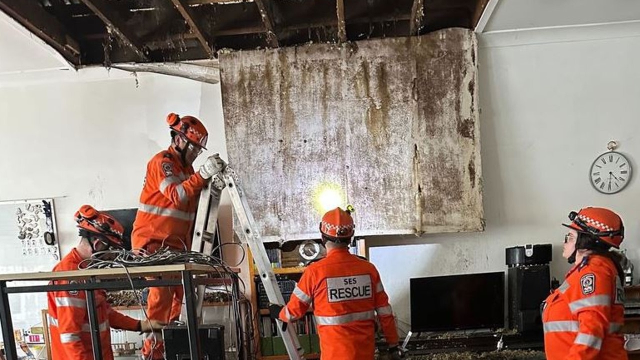
Horror hailstorm leaves family with $10k bill
A family of nine have been left devastated after their roof caved in and their house was decimated by golf-sized hailstones during a wild storm.
Shock death as storms smash southeast
Wild weather across Australia’s southeast this weekend has turned deadly – with police confirming a camper has died after being crushed by a falling tree.