
Map of Government’s new preferred Northern Prison site causes concern among residents
A government distributed map has sparked concern and outrage from residents whose property neighbours land slated for a prison development. SEE THE LATEST + FULL MAP DETAILS >>
The Launceston News
Don't miss out on the headlines from The Launceston News. Followed categories will be added to My News.
- Government abandons Westbury as preferred northern prison site
- No fence, no prison? Environment claims over prison site
LANDOWNERS are “astounded” by a state government distributed map which they say shows intention to lay claim to private property as part the proposed Northern Regional Prison development at Brushy Rivulet.
But, the government says markings on the map were only done as an example, and bushfire management was still being considered.
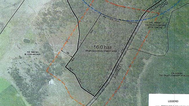
The map was drawn up by Land Tasmania’s Surveyor General one week prior to the announcement of the new preferred prison site on Birralee Rd and was handed out by Department of Justice representatives at a meeting with residents on July 1.
It showed a 16ha block earmarked for the 275-bed prison development on a 70ha Crown land bush site 5km from Westbury on Birralee Rd.
It also showed a 100m “bushfire clearance buffer zone” around the 16ha block marked in red, which extends into two privately owned neighbouring properties by 100m each and 100m into a 500m eagle’s nest buffer zone.
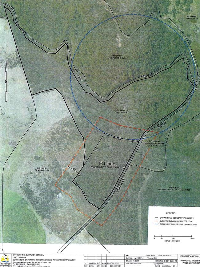
Concerned Residents Opposed to the Westbury Prison Site (CROWPS) calculated that the buffer zone would increase the land required by 19.5ha.
CROWPS spokesman Aaron Reader said the government had “seriously blundered” the location of the proposed site.
“CROWPS members were astounded to learn from the map that the Tasmanian Government has the audacity to lay claim to 100m bushfire buffer zone on neighbouring properties without any form of communication with landowners,” he said.
A government spokesman said the map was requested of the Surveyor General and the markings were only drawn up as an example.
Corrections Minister Elise Archer said fire management would be considered as part of the normal approval processes “as with any development”.

“The Department will prepare a bushfire hazard management plan that includes how any fire risk to the prison will be mitigated, including managing the risk from surrounding bush.
“The prison is likely to only require a footprint of approximately 15 hectares of the 70 hectare site, providing opportunity to manage any environmental features of the site.”
Mr Reader said a recent Supreme Court decision regarding the vulnerable use facilities in bushfire risk areas further proved a prison could not be built in bushland.
Justice Alan Blow ruled in June to uphold an appeal against the use of a former school in the Meander township for a drug and rehabilitation centre as ‘vulnerable use’ facilities cannot be placed in bushfire prone areas unless it meets a number of other criteria. patrick.gee@news.com.au

Everything you need to know about this year’s state budget
Tasmanian treasurer Guy Barnett has delivered his no-frills first budget. WHAT’S IN IT >>

Businesses ‘cannot afford’ to keep Garwood as mayor: Chamber
A key business body has broken its silence on the controversy surrounding Launceston mayor Matthew Garwood after his post with American rocker Ronnie Radke. Here’s the latest