
Tasmania weather: Antarctic blast brings low-level snow, hail, wind and sleet
It’s just over two weeks until summer but Tasmanians have woken to thick snow as low as sea level in parts. LATEST PICS, FORECAST + WARNINGS >>
Weather
Don't miss out on the headlines from Weather. Followed categories will be added to My News.
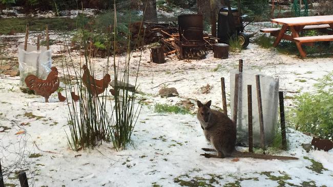
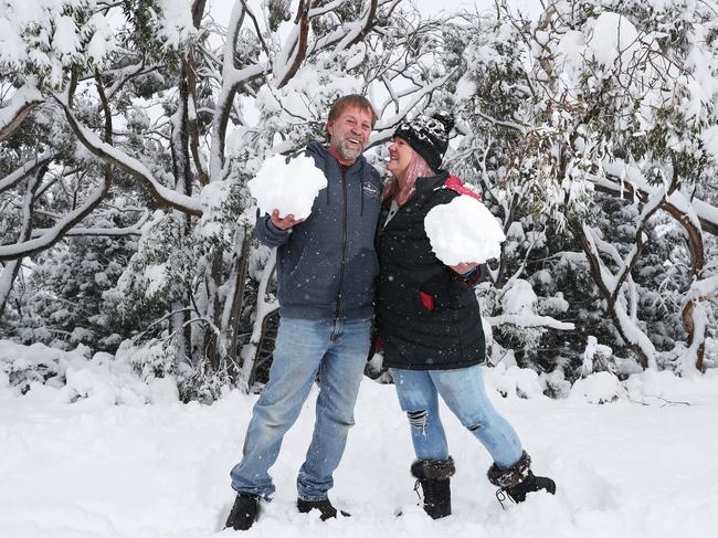
TASSIE’S capital shivered through its coldest November morning in nearly 70 years, as residents on Bruny Island awoke to a “magical” scene as snow fell at sea level.
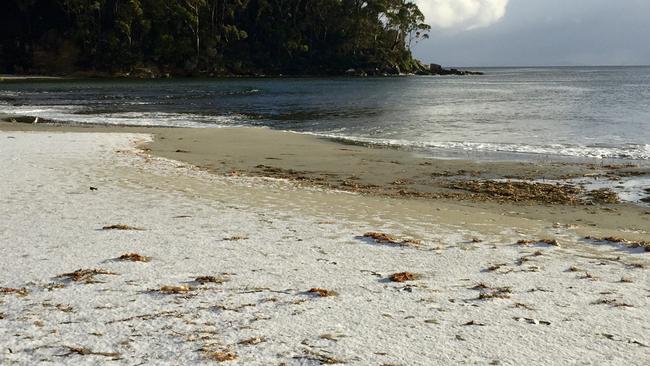
Forecasts of snow falling to below 200 metres rang true yesterday, with reports of snow settling in New Norfolk, the Huon Valley and sea level at Port Arthur and Adventure Bay on Bruny Island.
>> SCROLL DOWN FOR PHOTO GALLERY
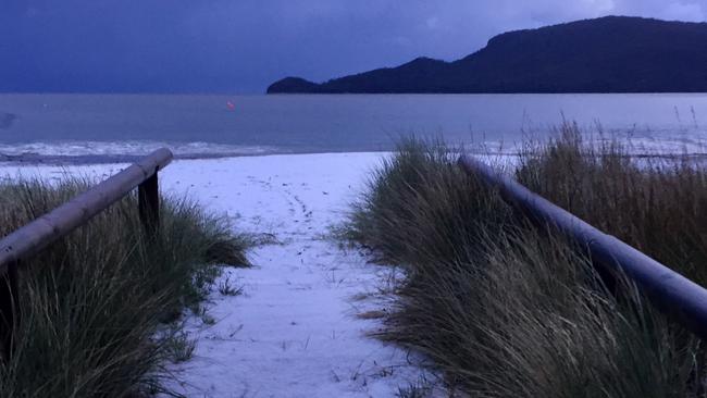
Jan Hunt was stunned when she woke to find her yard at Adventure Bay, Bruny Island completely white Monday morning.
While some speculated it was just hail, Bureau of Meteorology meteorologist Anna Forrest said images taken by Ms Hunt “definitely looks like snow”.
“It was certainly heavily covered for it to just be hail,” Ms Hunt told the Mercury.
“I got up at 4am and my whole yard was completely covered. I went down to the beach at 5.30am and the whole Adventure Bay beach was covered in snow … it looked so pretty.”
Ms Hunt said she’s lived on Bruny for two years, and talking to her neighbours they said it’s been over 12 years since it snowed on the island.
“I’ve heard other people talk about snow in the past but certainly I’ve never known it to snow before … the amount of it was what stunned me,” she said.
“I took photos of my neighbours’ shacks with their yards completely covered.
“My walkway down to the beach was so thick … and with my fairy lights turned on it just looked magical.
“It’s just been a magic morning.”
The Bureau of Meteorology confirmed a few November minimum temperature records were broken, as well as some late season minimum temp records as well.
For Hobart, a low of 2.9C at 5.39am was the coldest November temp since 1953 — 68 years ago.
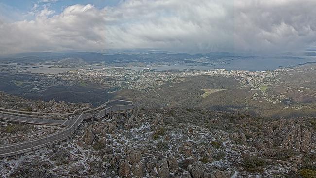
Up on kunanyi/Mt Wellington, the mercury dipped to a freezing -5.7 at 4.30am — with a ‘feels like’ temperature of -19.2C.
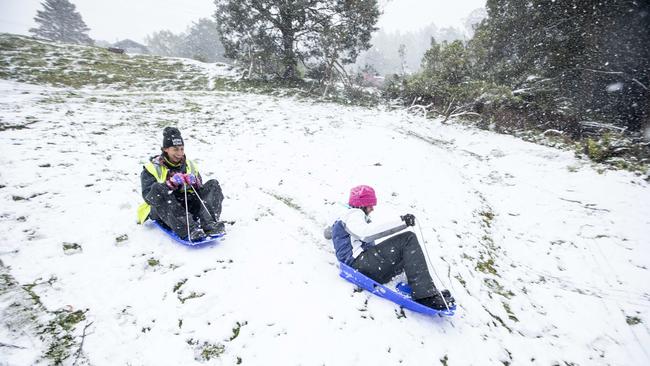
Another dumping of snow was expected overnight and into Tuesday down to 700 metres, with a bush walkers weather alert current.
The Bureau said a ridge would build to the north of Tasmania during Tuesday, with winds easing and tending more westerly.
An area of low pressure and an associated trough will move over Tasmania later Thursday, bringing increased showers and warmer maximums of 18 degrees.
As of 6pm Pinnacle Road at Bracken Lane on kunanyi/Mt Wellington remains closed.
#snow has fallen to relatively low elevations overnight in #Tasmania, but it's expected to retreat to higher elevations during the day. #cold#AntarcticBlasthttps://t.co/Q968D2T55Vpic.twitter.com/B7fn2PZ5p2
— Bureau of Meteorology, Tasmania (@BOM_Tas) November 14, 2021
Rescue in wild weather
Two families were pulled from the snow in the early hours of Monday morning after a four-wheel-driving expedition went awry on Jeffreys Track in Tasmania’s south.
Around 11.35pm Sunday night police received reports that a group of people in two 4WDs had ran into trouble on popular 4WD track, and they couldn’t be reached by mobile phone.
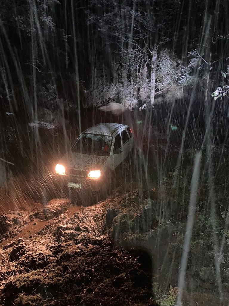
The Westpac Rescue Helicopter and ground Search and Rescue parties were tasked to the area but due to last night’s snow and poor weather the chopper was called off at 1.30am.
A ground search made up of four Tasmania Police 4WDs found the missing group at a “notable bog point” called the Pigs Pen Loop at 2.45am Monday morning.
The two adults and six children (children aged between 6 and 15) were found safe and well but bogged.
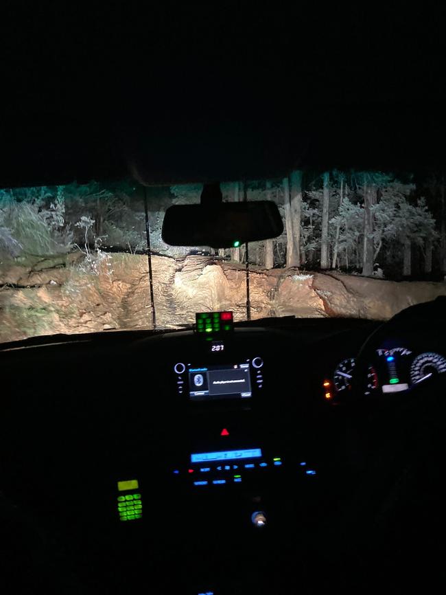
Senior Constable Callum Herbert said both vehicles were fortunately still working, allowing the stranded expeditioners to stay warm in what was the coldest November night since 1963.
The heaters were going, there was a number of children in the cars and they were reported to be comfortable, if not asleep at the time,” he said.

He said while it’s okay to tackle the track, people should be prepared for the weather and should make sure their vehicles are up to the tack
“We don’t mind people going out into the wilderness,” he said.
“It’s an open four wheel drive track, but think about what the weather’s doing at the time.
“Think about the capability of your motor vehicle, have a rescue plan, and consider taking PLB locator beacon with you in case you get in trouble.”
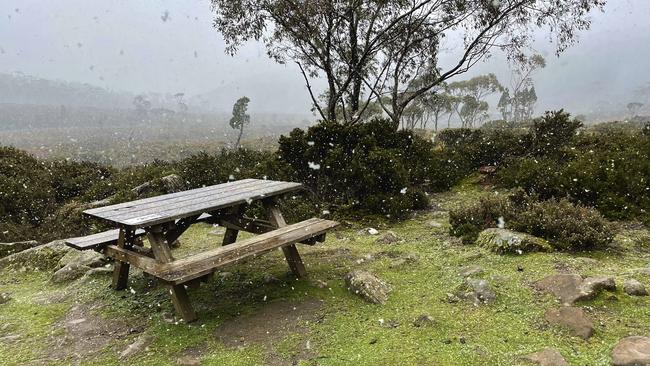
Rare Antarctic blast to bring snow down to 200m
With less than three weeks until summer, snow hunters could be in for a treat with flurries forecast to fall down to 200m above sea level this evening and into Monday.
The nippy conditions will also bring hail, wind and sleet to elevated areas across the state after a cold front passed through Tasmania this morning followed by a trough later tonight.
“They will be some snow falling on Mt Wellington – it will struggle to settle on low levels but there will be flurries around 200m to 400m above sea level early Monday, slowly rising throughout the day up to 700m.” aid BOM meterologist Glenn Perrin.
#Tasmania will see a cold outbreak over the state late Sunday into Monday after the passage of a cold front and a trough. While snow to expected to fall to around 200 to 400m, it will struggle to settle to such low levels at this time of year. Take care and heed warnings. pic.twitter.com/m9hBQ5A7AF
— Bureau of Meteorology, Tasmania (@BOM_Tas) November 13, 2021
“The trough is bringing cold air through early hours of Monday with showers about the west, south and central as well as the Bass Strait islands – they’ll ease from late afternoon with possible isolated showers elsewhere.”
Higher elevated areas in the west and south of the state are expected to see most of the snow with alpine locations such as the Cradle Valley, Liawenee, Lake St Clair and parts of the Overland Track to have a near 100 per cent chance of snow showers.
Flurries were already spotted by a Tasmanian at Lake Dobson in Mount Field National Park early Sunday.
As the Antarctic blast hits temperatures will dip across the state overnight and into Monday before warming up by the end of the week reaching 19C in Hobart on Thursday.
As of Sunday afternoon the weather bureau has issued numerous warnings across the state including a road weather alert for snow in Western, Central Plateau, Upper Derwent Valley and South East districts.
A sheep graziers warning is also current as well as a bush walkers weather alert for Western and Central Plateau regions.
Full forecast and weather warnings head to the Bureau of Meterology’s website.
Fresh warnings as “unusual” cold blast heads for Tassie – Sarurday, November 13
A number of warnings have been issued for an intense cold blast expected to hit Tasmania with “unusual” low level snow late Sunday.
The Bureau of Meteorology has issued a Sheep Graziers warning for King Island, Furneaux Islands, North West Coast, Central North, North East, Midlands, East Coast, Upper Derwent Valley and South East forecast districts.
Forecasted snow to low levels has also prompted a Bush Walkers Weather Alert for Western and Central Plateau.
According to the Bureau of Meteorology, a cold front on Sunday morning followed by a trough late Sunday and early Monday will see “cold and showery” conditions across Tasmania, with snow as low as 200 metres expected on Sunday evening into Monday.
The worst of which is expected to lash the south of the state.
Showers expected across #Tasmania for the next few days following yesterdays rainfall 🌧ï¸... until cold fronts on Sunday and Monday bring cold, wet and windy conditions with snow likely 🥶 Forecasts and warnings at https://t.co/vZ9qAPX0nopic.twitter.com/RGmMJOnUWt
— Bureau of Meteorology, Tasmania (@BOM_Tas) November 11, 2021
While snow at that level is low, BOM meteorologist Brooke Oakley said it’s unlikely it will settle at lower elevations.
“Icy sleet-like showers, small hail and wind gusts peaking at 70-80 km/h are expected,” she said.
“Thunderstorms are possible during Sunday and should contract to the far south by early Monday.”
The Bureau said temperatures have already been below average in Tasmania this week, and will remain cold until the middle of next week.
“The weather will deteriorate during Sunday as the front crosses, but the most significant weather will be overnight Sunday,” Ms Oakley said.
“Cold fronts occur year-round in Tasmania, and snow to low levels is unusual at this time of year, but not unprecedented.”
“We are urging people travelling around the state to be prepared.”
BOM warns a Road Weather Alert will likely be issued.
COLD SNAP: Pinnacle Rd to close ahead of forecast snow – Friday, November 12
The City of Hobart will close Pinnacle Road at The Springs at 4pm today due to forecast snow.
A number of “vigorous cold fronts” are set to bring an Antarctic blast of cold weather across Tasmania this weekend, with low-level snow, sleet and hail set to interrupt spring.
The Bureau of Meteorology said the coldest air would move over the state on Monday and it was likely Hobart would only reach 13C and Launceston 14C.
Meteorologist Luke Johnston said the cold snap would bring snow to low levels across many parts of Tasmania.
“Temperatures this week already have been below average for Tasmania with a lot of southerly winds maintaining below average temperatures, but we’re expecting to see an even more significant blast of cold air come over the state Sunday night into Monday as a series of vigorous cold fronts bring icy conditions over the state,” Mr Johnston said.
“Showers and thunderstorms are expected to develop on Sunday ahead of the first of this series of cold fronts. And as the cold front comes across the state, we’ll see colder and colder conditions with hail, showers, sleet and then snow down to fairly low level Sunday night into Monday.”
Mr Johnston said the coldest air and the lowest snow would be the early hours of Monday where snow is expected to fall down to around 400 metres with falls to around 200 metres possible.

“However, at this time of the year, it’s unlikely we’ll see snow settling to those lower elevations as the grounds just starting to get a bit warmer associated with these frontal systems as well,” he said.
It will also be windy across the state, with wind gusts around 80-90kmh on Sunday and Monday.
“Conditions will slowly ease during Monday and snow eventually contracts to above 500 metres by Monday evening,” Mr Johnston said.
“The coldest day is expected to be Monday with maximum temperatures well below the November average, with Hobart likely to only reach 13 degrees and Launceston 14 degrees so quite a cold day for Tasmania in the lead up to this event.
“Just be aware if you’re travelling around Tasmania that Sunday’s weather will change and deteriorate as the day develops.”
Showers about the southern parts of #Tasmania today, but sunshine in the north. A little too much rain for the Jordan River, a minor flood warning is current. See all the rain that has fallen and which is expected at https://t.co/DCMDy1MV9Fpic.twitter.com/0zpCr2dyZu
— Bureau of Meteorology, Tasmania (@BOM_Tas) November 10, 2021
A road weather alert will likely be issued on the weekend for low snow settling onto some of the roads particularly over the Central Plateau, as well as a sheep graziers and bushwalkers alerts.
As far as where the snow is likely to fall, Mr Johnston said it would be quite spread out.
“Being in a westerly air stream the majority of snow is expected to fall about the Central Plateau in the western districts of Tasmania,” he said.
“But snowfalls are still possible about the northeast highlands of Tasmania on Sunday night into Monday, but just not as much as what’s expected further west and south.”
The meteorologist said it was “quite normal” to see cold fronts come over Tasmania year round, even this late in the spring or even over summer.
“It’s not that unusual to see snow falling with the passage of fronts this late in the year in Tasmania, but having snowfall down to such low levels is a little bit uncommon,” Mr Johnston said.


Floods, snow and sun: A week in Tasmanian weather
The weather is keeping Tasmanians on its toes with a few changes on the way, including promising signs for a slightly warmer weekend before another wintry blast brings snow. FORECAST >>
Pictures: King tide rolls in as low-lying coastal community braces
An abnormally high tide has begun to roll in across the state’s South East after a coastal hazard warning was issued. Pictures >>