
Warning as deluge, thunderstorms and hail sweeps across Tasmania
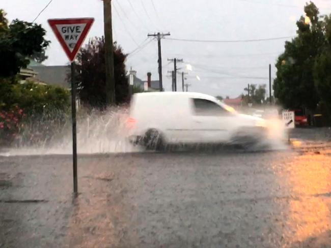
UPDATED: Severe thunderstorms and heavy rainfall smashed Greater Hobart in an intense two-hour period, causing flash flooding across the area.
Tasmania
Don't miss out on the headlines from Tasmania. Followed categories will be added to My News.
UPDATED: HOBART was smashed with severe thunderstorms and heavy rainfall in an intense two-hour period which caused flash flooding across the Greater Hobart area.
Hobart recorded 27mm of rainfall in the 1.5 hours to 7pm on Sunday, as did Leslie Vale.
The heavy rain caused flash flooding on many Hobart streets including the corner of Duke and Regents streets in Sandy Bay; Campbell St in the Hobart CBD and Risdon Rd, New Town.
Sections of the Hobart Rivulet were also damaged and flash flooding hit the Tasman Bridge.
Tasmania Police issued a warning to drivers to be careful at the height of the downpour.
“Due to the extreme weather event a number of roads in Southern Tasmania have flooded,” a police spokesman said.
“Motorists are asked to exercise extreme caution and avoid travel where possible in the greater Hobart area.”
Hobart storm cell just turned on a water feature I never knew existed, until now @themercurycomau pic.twitter.com/CWIr8JcRfi
— John Sampson (@spencerjsampson) December 16, 2018
Large hail, 2cm in size, was reported at Brighton and Eastlands shopping centre, in Rosny Park, also sustained flood damage.
A severe weather warning was also in place across a large chunk of the state including Swansea, Strahan, New Norfolk, Geeveston and Dover on Sunday.
Apart from the deluge of rain, Tasmanians also had to contend with humid, tropical conditions.
In the state’s North-East, Gray recorded 80mm of rain in the 24 hours to 9am on Sunday and Swansea in the East copped a drenching of 51mm.
Bureau of Meteorology senior forecaster Rachel McInerney said the low-pressure system that brought all the rain was moving away from the state.
“[On Monday] there will be showers, a cooler air mass and it will certainly be less humid,” she said.
‘It should be a lot calmer in the days ahead.”
Hobart should reach a max of 23C with a shower or two possible.
Cooler conditions are expected for the rest of the week with temperatures expected to hit the late teens.
Hobart Rivulet at the Hospital this afternoon feeling the strain of the quick downpour. pic.twitter.com/hR4BLoAOZ9
— Triple M Hobart (@mmmHobart) December 16, 2018
Flash flooding and hail on the Brooker .. slow down @themercurycomau @SeaFMTasmania pic.twitter.com/jORW9K4qyi
— tasmaniawhyweloveit (@taswelove) December 16, 2018
EARLIER: THE Bureau of Meteorology has issued a severe thunderstorm warning for Hobart and surrounds.
The Bureau said a severe storm cell, moving southeast, is approaching Glenorchy and is expected to move over the Hobart CBD by 6.30pm.
Heavy rainfall and 2cm hail was reported with this cell at Brighton.
Large hailstones and heavy rainfall that may lead to flash flooding are likely.
The rain is really coming down with these storms in #Hobart Please take care on the roads. All current warnings at https://t.co/1MVVpQqVQ3 @SESTasmania @BOM_au pic.twitter.com/HGBpfLIy5c
— Bureau of Meteorology, Tasmania (@BOM_Tas) December 16, 2018
A severe thunderstorm warning remains in place for the Western, Upper Derwent Valley, South East, East Coast, Central Plateau, Midlands and parts of the North East, North West Coast and Central North districts.
Police are urging drivers to be careful after heavy rainfall led to a number of roads in Southern Tasmania being flooded.
“Motorists are asked to exercise extreme caution and avoid travel where possible in the greater Hobart area,” a Tasmania Police spokesperson said.
The detailed Hobart thunderstorm warning has been updated. A severe storm cell in approaching Glenorchy and is expected to move over the Hobart CBD within the hour. Heavy rainfall and 2 cm hail was reported with this cell at Brighton. View warnings here: https://t.co/NHL3HY0zFO pic.twitter.com/7G5qYZCbMh
— Bureau of Meteorology, Tasmania (@BOM_Tas) December 16, 2018
MORE NEWS:
HOLIDAY HEADACHE AS STAFF SHORTAGE BITES
TASSIE’S $90M BOOST FROM AIRBNB
EARLIER: Tasmanians should brace for humid and tropical conditions with thunderstorms and hail expected to sweep across the state this afternoon.
Burnie has already been hit by heavy downpours with police issuing a warning for motorists driving in the area.
“Some parts of the Bass Highway have patches of water,” police said.
“A reduction in speed and driving according to the conditions will assist in ensuring people arrive safely at their destination.”

Bureau of Meteorology Tasmania senior forecaster Alex Melitsis said widespread thunderstorms and intense rainfall was possible in all areas.
“We’re looking at very humid, unsettled, almost tropical conditions across much of the state and these conditions are going to be conducive to afternoon thunderstorms,” he said.
“It’s not too unusual, it’s what usually happens in eastern Tasmania — you get infrequent big dumping’s and then it’s usually dry for much of the year.”
He said large hail of about 2cm was also possible.
He said a moderate flood warning was still in place for the South Esk River and the Bureau would issue thunderstorm warnings this afternoon if they develop.
The storms are predicted to ease by tonight.
“We’re looking at much more benign weather for the next few days,” Mr Melitsis said.
Rain fell in most areas of Tasmania overnight with the highest totals recorded at Gray (79mm), 58mm at Swansea, 51mm at Pyengana and 49mm at Little Swanport.

EARLIER: Grab your raincoats, because Hobart may cop some heavy rain today, with the chance of hail and thunderstorms in the afternoon.
The North of the state was drenched yesterday and heavy falls are expected to continue today, with the weather bureau warning of potential flash-flooding.
The North-East is expected to receive 150mm across the weekend.
MELBOURNE RECOVERS FROM EPIC RAIN, BUT MORE COMING
SYDNEY STORMS LEAVE TENS OF THOUSANDS WITHOUT POWER
A moderate flood warning is current for the South Esk River and a flood watch has been issued for the North, North-East, North-West, East Coast and Furneaux Islands.
The Bureau of Meteorology has also issued a severe weather warning for heavy rain in the East and North-East today.
A road weather alert for slippery roads and heavy rain was also issued. Heavy downpours and flooding forced police to close Rosedale Rd between Bicheno and the Douglas-Apsley National Park and Ansons Bay Rd at Ansons Bay yesterday.
Binalong Bay Rd at the Binalong Bay causeway crossing Georges River was also closed, with police recommending drivers use Reids Rd to get to Binalong Bay.
Bureau senior meteorologist Rachel McInerney said conditions would see more showers than thunderstorms today before the rain eases as the low pressure system moves away to the southeast tomorrow.
State Emergency Service acting regional manager Michael D’Alton encouraged East Coast residents to prepare their properties for the hazards associated with heavy rain, flash flooding and thunderstorms.
He said farmers should move stock and equipment to high ground.

Man found guilty of multiple abuse charges against teen girls
A North-West man faced 16 charges relating to sex crimes against schoolgirls. What the jury found after a long and complex three-week trial:

Barbering with a twist lands in Glenorchy
Designer-turned-barber Nigel Vogler and co-founder Carlos Lira have opened Lounge and Blade, a new Glenorchy space for haircuts and locally made leather.