
Voyage to study sea floor and boost earthquake and tsunami monitoring
A scientific project to remote Macquarie Island which will produce the first high-resolution maps of the sea floor will also boost seismic monitoring.
Tasmania
Don't miss out on the headlines from Tasmania. Followed categories will be added to My News.
- ‘Unbelievable’: Sue Neill-Fraser’s 2020 appeal hopes crushed
- Every home sold in regional town made a profit
A VOYAGE of geological discovery to Macquarie Island will allow scientists to monitor the sea floor and be warned of future earthquakes and tsunamis.
Scientists will set sail from Hobart on Friday to conduct a month-long exercise to shed light on the island’s underlying structure and geological evolution.
The study will be led by Institute for Marine and Antarctic Studies Professor Mike Coffin and include scientists from ANU.
The voyage on Australia’s national research vessel Investigator, owned and operated by CSIRO, will allow researchers to produce the first high-resolution maps of the sea floor surrounding Macquarie Island.
At the same time, ANU scientists led by Professor Hrvoje Tkalčić will deploy seismometers on the sea floor to investigate the region’s crustal and mantle structure as well as its seismicity.
Professor Coffin said Macquarie Island sat on the highly active tectonic plate boundary between the Australian and Pacific plates.
The plate also generates some of the largest intra-oceanic earthquakes away from subduction zones.
“The creation of sea floor maps identifying faults, fracture zones, and relict sea floor spreading centres will yield insights into the structure, behaviour, and history of this important plate boundary, which presents significant tsunami hazards for both sides of the Tasman Sea,” Professor Coffin said.
“The maps will also shed light on why and how Macquarie Island, which formed around 2500 metres below sea level, was thrust above sea level.
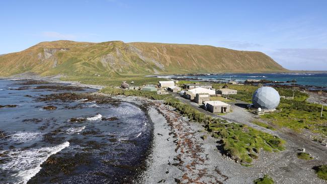
“World Heritage-listed because of its unique geological exposures of both crustal and mantle rocks, the island hosts Australia’s only sub-Antarctic research station, which includes a seismometer.”
Twenty-nine seismometers will be deployed on the sea floor and recovered in late 2021 or early 2022
The data returned will be critical to addressing the project’s seismological objectives.
“Such a remote and unique location chosen for our experiment will also improve the spatial coverage of the Earth’s deepest interior by seismic waves of distant earthquakes recorded by our seismometer array, and enable a range of geophysical studies, including interactions of the ocean and atmosphere with the solid Earth,” Professor Tkalčić said.

$47m lost: Tasmania’s worst pokie hotspots
Tasmanians are losing more than $47 million as the state’s worst pokies hot spots can be revealed. Search our interactive table and see how your suburb compares.

Not just a lawyer’s picnic: Why Human Rights Act should be priority for Tassie indies
The Australian Lawyers Alliance is calling on Tasmanian Independent MPs to ensure a Human Rights Act is part of any negotiation with the major parties to form government. WHAT IT WOULD MEAN