NewsBite

LIVE

After weeks of rain, strong winds are being forecast for most of the state

Tasmanians are being warned to brace for strong and damaging winds across the state. FOLLOW LIVE

Picture: Tasmania Weather Watch, Facebook

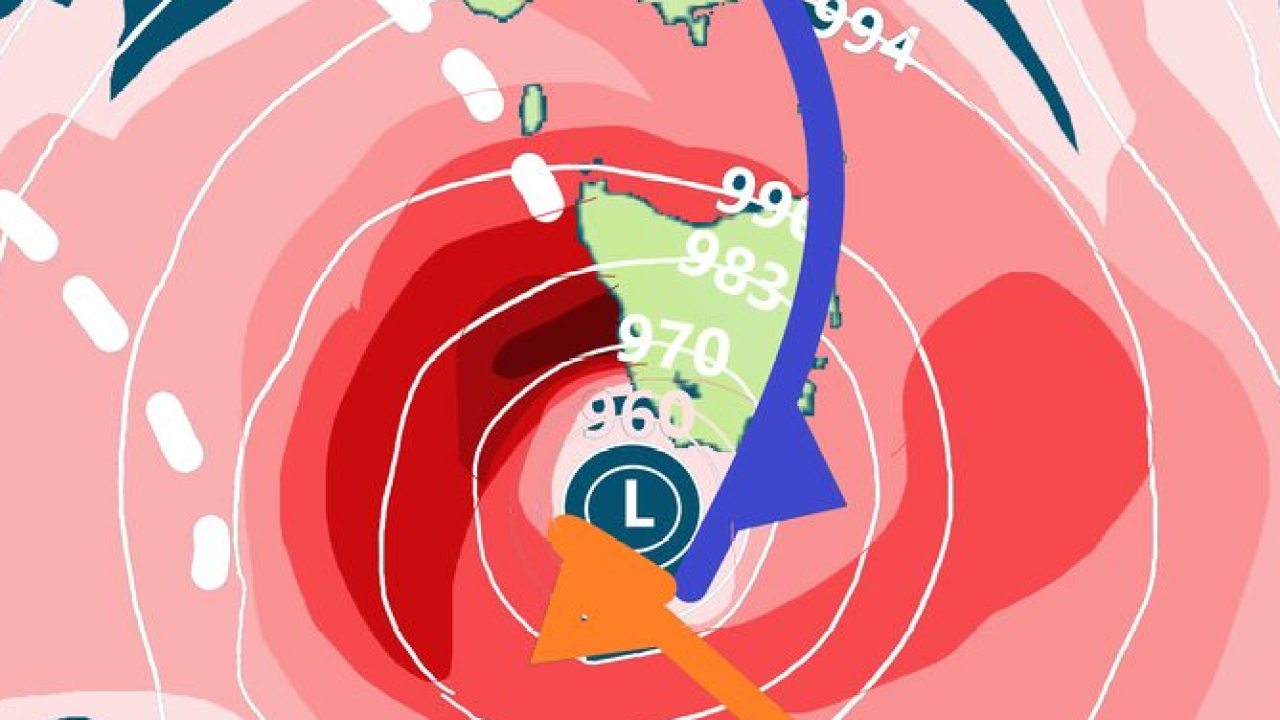
AS Tasmanian farmers count the cost of some of the heaviest rainfalls in 34 years, the weather bureau has warned of strong and damaging winds on Monday and further rain in the North.


Follow the latest in our blog below.

Live Updates

SES warns Tasmanians to prepare for damaging winds

Tasmanians are being warned to brace for strong and damaging windows across the State on Monday and severe thunderstorms in the south.

State Emergency Service acting director Leon Smith said a severe weather warning issued by the Bureau of Meteorology showed the damaging north-westerly winds were expected across the entire state.

“We're working closely with the Bureau to monitor and prepare for the forecast conditions, which includes wind gusts of 90 to 100 km/h,” he said.

“Severe thunderstorms are also possible in the southern half of Tasmania, which could increase the risk of destructive wind gusts, flash flooding and hazardous driving conditions.

“With recent persistent rain, wet soil and damaging winds, there is significant potential for trees and powerlines to be brought down, right across Tasmania.”

SES volunteer crews will be ready to help if need and Tasmanians are being asked to ensure their properties are as “prepared as possible, by ensuring those niggling maintenance jobs are done before the damaging winds occur”.

“Be proactive and secure any loose items such as outdoor furniture and play equipment,” Mr Smith said.

“Trampolines especially are often an issue in high wind events, so please tie them down.”

The State Emergency Service advises people to supervise children closely, check that family and neighbours are aware of warnings, manage pets and livestock and be aware of fallen trees or power lines when driving.

Power outages can be reported to TasNetworks on 132 004 and the SES can be contacted on 132 500.

People can get further information and keep up to date at http://www.bom.gov.au/tas/warnings/ – for the latest weather forecast and warnings.

Strong winds are on the way

The Bureau of Meteorology expects wind gusts of 90 to 100km/h across most of the state which could exceed 100km/h in the south, including Hobart.

It has forecast widespread rainfall in North-West and North-East which could see minor flooding. While flooding has been extensive, Tasmania is unlikely to break the record for the wettest October.

Senior climatologist Jonathan Pollock said some weather stations had set new daily and monthly rainfall records for October.

“But for Tasmania overall, October 2022 isn’t close to ranking in the top 10 wettest Octobers,” he said.

“We’re currently sitting on 152.11 mm (which will rise by the end of the month) and the record is 288.08 mm in October 1988.”

Mr Pollock said November and December were still likely to be wetter than average across North-Eastern Tasmania.

“In contrast, parts of the South-West are likely to have below average rainfall in November.”

Tasmanian Farmers and Graziers Association CEO Hugh Christie said the greatest damage for some farmers was the loss of top soil from flooding. He said some farmers had lost fences that took three years to fully replace following the 2016 floods.

“There has been infrastructure damage, ranging from fences, irrigation equipment and farm roads to crop and pasture losses,” Mr Christie said.

“Lost crop production will also become increasingly apparent as time progresses due to a combination of direct losses during floods, waterlogged crops not germinating and delayed planting due to a combination of the floods and ongoing rain impacting on productivity.

“While these impacts are significant, the greatest damage for some farmers is the loss of topsoil due to floods combined with ground being prepared for crops.Fruit growers remain relatively unscathed from the rain.But Fruit Growers Tasmania CEO Peter Cornish said rain and humidity caused greater disease pressure.

“It also slows down the growing of the plants, hence delaying the season,” he said.

“With the orchards so wet and slippery, a problem is getting tractors into the orchards to spray.

“Overall the season ahead still looks very good and hopefully we are in for a bumper harvest.”

People wanting to help rural communities recover can donate to Rural Relief Fund https://www.ruralbusinesstasmania.org.au/relief-fund

Rain easing but wind, flood threat high

A low pressure system is continuing to bring rainy conditions overnight and into Thursday, with authorities warning rivers "will respond rapidly to rainfall".

The Bureau of Meteorology said the highest falls were likely about the east and southeast of the state with locally higher totals possible about eastern facing slopes and in elevated areas. Rainfall will contract to the southeast overnight Wednesday and will ease during Thursday.

Flood warnings are current for the Macquarie River, Meander River, North Esk River, South Esk River and Coal River, and renewed rises are occurring at many locations.

Localised flooding is expected in small creeks and low lying areas in locations that receive heavy rainfall.

Catchments likely to be affected include:
♒ East Coastal Rivers (north of Bicheno)
♒ Ringarooma River
♒ North Coastal Rivers
♒ Tamar (Launceston)
♒ Huon River
♒ Channel Coastal Rivers (South East Cape to Gordon)
♒ Derwent River
♒ Jordan River
♒ East Coastal Rivers (south of Bicheno)
♒ South East

A severe weather warning is current for the South East, East Coast, Central North, Midlands and parts of North East, North West Coast, Central Plateau and Western forecast districts.

Damaging wind gusts of about 80km/hr are forecast to continue about elevated areas in the North East, Tamar Valley region and western tiers, easing by mid-afternoon.

Heavy rainfall that may lead to flash flooding is forecast for the eastern aspects of elevated areas across the East Coast and South East forecast districts today including Kunanyi (Mount Wellington). Heavy rainfall is expected to gradually contract south throughout the day to the Huon Valley by this evening.

Six-hourly rainfall totals between 20 to 40mm are expected, with isolated falls to 60mm likely. 24-hourly rainfall totals between 40 to 60mm with isolated falls to 100 mm likely.
Locations which may be affected include Launceston, St Helens, Swansea, Orford, Geeveston, Dover and Kunanyi (Mount Wellington).
Nugent recorded 58 mm in the 6 hours to 10:30am.

A road weather alert was also issued at 1.02pm Wednesday that 'reduced visibility in heavy rain and possible water over roads may make road conditions dangerous during Wednesday in parts of the East Coast and South East forecast districts'.

Fallen rocks block road at St Marys Pass

Two large fallen rocks have blocked the westbound lane at St Marys Pass, Tasmania Police have said.

There are portable warning signs placed at the location and State Growth have been notified.

Motorists are urged to use caution while travelling through the area, delay their travel or use an alternative route if possible.

Severe weather warning issued

A low pressure system near the state's northeast is forecast to move close to the northeast coast of Tassie early this morning, bringing associated damaging southeasterly winds and moderate rainfall.

In a severe weather warning issued at 4.59am, the Bureau of Meteorology says the low is expected to gradually move over northern Tasmania and weaken slightly later today.

Damaging wind gusts of about 80km/hr are forecast to continue in the North East and develop about the Tamar Valley and southeastern coastal fringes early Wednesday morning. Winds will ease later this morning.

The Bureau warns recent rainfall has led to saturated soils in parts of the northeast, leading to an increased risk of gusty winds toppling trees and powerlines.


Moderate rainfall is forecast for parts of the East Coast from early this morning, and the South East from around dawn, easing towards midday.

Six-hourly totals of 20 to 40mm are expected, with isolated falls up to 60mm.
Locations which may be affected include Devonport, Launceston, St Helens, Swansea, Geeveston and Dover.
A wind gust of 98km/h was recorded at Larapuna (Eddystone Point) at 3.12am.

Forecast rainfall for Tasmania. Supplied by Tasmanian Weather Watch TWW

Tasmanian Weather Watch urged those to heed warnings, particularly because Hobart's main weather radar is offline for maintenance.

"For communities in the Northeast, Flinders island, East Coast, Southeast Coast including Hobart and parts of the Huon and Upper Derwent Valley … this situation remains dynamic so please over the next 24 hours you need to be on high alert for severe weather including damaging winds, moderate to locally heavy rainfall and widespread flooding," TWW said.

"Showers to areas of moderate rain developing overnight about the Northeast of the state extending along the East Coast during Wednesday morning and into the Greater Hobart, Southeast Coast, Huon Valley and Upper Derwent Valley by the evening.

"Locally Heavy Rainfall that may lead to flash flooding is possible within slow moving rain areas or Thunderstorm activity for all mentioned areas."

Flood Watch and Act for Fingal to Hanleth and surrounds

A Flood Watch and Act – Monitor conditions as they are changing has been issued for Fingal to Hanleth and surrounds by Tasmania SES.
The Bureau of Meteorology has issued a moderate flood warning for the South Esk River.
Locations likely to be impacted are: Fingal, Avoca, Ormly, Hanleth and surrounds
During the next 24 to 48 hours:
Flooding is likely in streams and rivers.
Lives could be at risk from flood waters.
Some properties may become isolated or inundated by flood waters.
Evacuation of some properties may be required.
Property, livestock, equipment, and crops may be threatened by flood waters.
Driving conditions may be dangerous.
Flood waters are a risk to safety, never walk, play, ride, or drive in floodwater.

What to do:
If you live in the alert area and/or near the South Esk River, SES advises:

  • If you have a flood emergency plan, use it now.
  • Prepare your property (if safe to do so). This may include:
  • Placing furniture and possessions up high on tables/benches
  • Move livestock and equipment to higher ground
  • Preparing your emergency kit and being ready to leave
  • If conditions worsen and safe to do so, leave and go to the home of a family member or friend who is in a safe location away from the flood affected area.
  • Contact family, friends, and neighbours to alert them of the potential for flooding.

For flood updates, visit TasALERT.com or listen to ABC local radio.

St Helens to prepare for up to 70mm of rain

Break O’Day Mayor Mick Tucker said St Helens could get up to 70mm of rain overnight and be buffeted by strong winds.
“We’re as prepared for the unexpected as we can be,” he said.
The sandbag depots at St Marys and Fingal remain fully stocked from previous weather events, he said.

Add your comment to this story

To join the conversation, please Don't have an account? Register

Join the conversation, you are commenting as Logout

Original URL: https://www.themercury.com.au/news/tasmania/tassies-big-wet-could-last-for-months-as-new-front-looms/live-coverage/a63a425e311f3d7a28a5f09f3941084a